Difference between revisions of "2023-07-07 43 -79"
([live picture]Would recommend you check out Ruby's if you ever find yourself at the lovely Eglinton Square mall) |
m (Location) |
||
| (7 intermediate revisions by one other user not shown) | |||
| Line 1: | Line 1: | ||
| − | + | [[Image:{{{image|2023-07-07 43 -79 frogman 1688759588759.jpg}}}|thumb|left]] | |
| − | + | {{meetup graticule | |
| − | |||
| − | |||
| − | |||
| − | |||
| − | |||
| − | |||
| lat=43 | | lat=43 | ||
| lon=-79 | | lon=-79 | ||
| date=2023-07-07 | | date=2023-07-07 | ||
| − | }} | + | }} |
== Location == | == Location == | ||
| − | + | A walkway between apartment buildings near Eglinton Square mall. | |
== Participants == | == Participants == | ||
| − | + | *[[User:Frogman|Frogman]] | |
| − | |||
| − | |||
| − | |||
| − | |||
== Expedition == | == Expedition == | ||
| − | + | This was a pretty straightforward one. 63 to Ossington Station, Line 2 to Victoria Park, 67 up Pharmacy. I snapped a few pictures at the hashpoint and then headed up to Eglinton Square mall for some lunch. I got a falafel wrap and two veggie samosas. The food was pretty good! I sat around in the food court for a while, doing exercises from my current self-study mathematics textbook (David M. Burton, "A First Course in Rings and Ideals"). | |
| − | + | Afterwards, I headed up to take some pictures of the newly-completed tram stations. These stops are for the surface portion of the new Line 5 Eglinton, which was scheduled to open this year, and last year, and the year before that, and in 2015, and is currently slated to open next year although many insiders have mentioned that there is no credible plan for finishing the construction. My goal is to get my PhD before Line 5 opens and it appears likely that this will happen. The problems, though, are with the underground portion of the line; the surface section looks quite nice and ready to go. | |
| − | |||
== Photos == | == Photos == | ||
| Line 49: | Line 38: | ||
Image:2023-07-07_43_-79_frogman_1688759773790.jpg|Would recommend you check out Ruby's if you ever find yourself at the lovely Eglinton Square mall | Image:2023-07-07_43_-79_frogman_1688759773790.jpg|Would recommend you check out Ruby's if you ever find yourself at the lovely Eglinton Square mall | ||
| + | |||
| + | Image:2023-07-07_43_-79_frogman_1688759788004.jpg|It's next to a library! | ||
| + | |||
| + | Image:2023-07-07_43_-79_frogman_1688759814178.jpg|O'Connor LRT stop | ||
| + | |||
| + | Image:2023-07-07_43_-79_frogman_1688759832992.jpg|O'Connor, close up | ||
| + | |||
| + | Image:2023-07-07_43_-79_frogman_1688759855725.jpg|Eglinton Avenue East | ||
| + | |||
| + | Image:2023-07-07_43_-79_frogman_1688759869011.jpg|One more view of O'Connor | ||
</gallery> | </gallery> | ||
| Line 54: | Line 53: | ||
{{#vardefine:ribbonwidth|100%}} | {{#vardefine:ribbonwidth|100%}} | ||
<!-- Add any achievement ribbons you earned below, or remove this section --> | <!-- Add any achievement ribbons you earned below, or remove this section --> | ||
| + | {{Public transport geohash | ||
| − | + | | latitude = 43 | |
| − | + | | longitude = -79 | |
| − | + | | date = 2023-07-07 | |
| − | [[ | + | | busline = the TTC |
| + | | name = [[User:Frogman|Frogman]] | ||
| + | | image = 2023-07-07_43_-79_frogman_1688759554536.jpg | ||
| − | + | }} | |
| − | + | __NOTOC__ | |
| − | |||
| − | |||
| − | |||
| − | |||
| − | |||
| − | |||
[[Category:Expeditions]] | [[Category:Expeditions]] | ||
| − | |||
[[Category:Expeditions with photos]] | [[Category:Expeditions with photos]] | ||
| − | |||
| − | |||
| − | |||
| − | |||
| − | |||
[[Category:Coordinates reached]] | [[Category:Coordinates reached]] | ||
| − | + | {{location|CA|ON|TO}} | |
| − | |||
| − | |||
| − | |||
| − | |||
| − | |||
| − | |||
| − | |||
| − | |||
| − | |||
| − | |||
| − | |||
| − | |||
| − | |||
| − | |||
| − | |||
| − | |||
| − | |||
Latest revision as of 20:47, 7 July 2023

| Fri 7 Jul 2023 in 43,-79: 43.7224042, -79.2987990 geohashing.info google osm bing/os kml crox |
Location
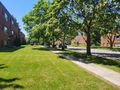
A walkway between apartment buildings near Eglinton Square mall.
Participants
Expedition
This was a pretty straightforward one. 63 to Ossington Station, Line 2 to Victoria Park, 67 up Pharmacy. I snapped a few pictures at the hashpoint and then headed up to Eglinton Square mall for some lunch. I got a falafel wrap and two veggie samosas. The food was pretty good! I sat around in the food court for a while, doing exercises from my current self-study mathematics textbook (David M. Burton, "A First Course in Rings and Ideals").
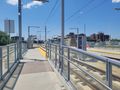
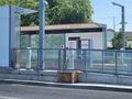
Afterwards, I headed up to take some pictures of the newly-completed tram stations. These stops are for the surface portion of the new Line 5 Eglinton, which was scheduled to open this year, and last year, and the year before that, and in 2015, and is currently slated to open next year although many insiders have mentioned that there is no credible plan for finishing the construction. My goal is to get my PhD before Line 5 opens and it appears likely that this will happen. The problems, though, are with the underground portion of the line; the surface section looks quite nice and ready to go.
Photos
Waiting for the bus at Victoria Park
Arrived!
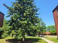
A lovely nearby tree

The geohasher
Nearby Engelhart Crescent
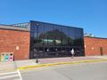
Eglinton Square mall, south entrance
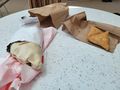
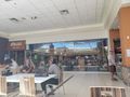
Lunch!
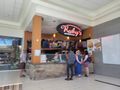
Would recommend you check out Ruby's if you ever find yourself at the lovely Eglinton Square mall
It's next to a library!
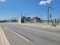
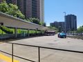
O'Connor LRT stop
O'Connor, close up
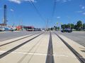
Eglinton Avenue East
One more view of O'Connor


Achievements
Frogman earned the Public transport geohash achievement
|