Difference between revisions of "2023-07-09 44 -0"
From Geohashing
| (11 intermediate revisions by 2 users not shown) | |||
| Line 1: | Line 1: | ||
| − | + | __NOTOC__ | |
| − | |||
| − | |||
| − | |||
| − | |||
| − | |||
| − | + | {{meetup graticule | |
| − | |||
| lat={{#explode:{{SUBPAGENAME}}| |1}} | | lat={{#explode:{{SUBPAGENAME}}| |1}} | ||
| lon={{#explode:{{SUBPAGENAME}}| |2}} | | lon={{#explode:{{SUBPAGENAME}}| |2}} | ||
| date={{#explode:{{SUBPAGENAME}}| |0}} | | date={{#explode:{{SUBPAGENAME}}| |0}} | ||
| − | }} | + | }} |
== Location == | == Location == | ||
| Line 21: | Line 15: | ||
[[User:Beltxarga|Beltxarga]] ([[User talk:Beltxarga|talk]]) | [[User:Beltxarga|Beltxarga]] ([[User talk:Beltxarga|talk]]) | ||
| − | == | + | == Expedition == |
| − | |||
| − | + | A not-so-interesting Geohash, except maybe from a few facts: | |
| − | |||
| − | + | * [[2013-07-14 49 4|My first Geohash]] was 10 years before this one, almost to the day! Memories and melancholy. Time flies and life goes by. Also, this was [[2014-04-25 46 -1|my first Geohash in more than 9 years]]. Uh-oh. | |
| − | + | * My first Geohash by bicycle! 🚲 I left from Bordeaux via Marcheprime. I parked my bicycle not too far from the Geohash. It was a 70 km round-trip and a 30 min walk. | |
| + | * The Geohash was located in some kind of pine harvesting forest, not difficult to reach but not very interesting from a scenery point of view. | ||
== Photos == | == Photos == | ||
| − | < | + | |
| − | Image: | + | <gallery> |
| − | -- | + | Image:20230709 195958 44 -0 1.jpg | On the way 1 |
| − | + | Image:20230709 200617 44 -0 2.jpg | On the way 2 | |
| + | Image:20230709 201021 44 -0 3.jpg | Getting very close | ||
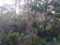
| + | Image:20230709 201515 44 -0 4.jpg | View #1 from the Geohash | ||
| + | Image:20230709 201519 44 -0 5.jpg | View #2 from the Geohash | ||
| + | Image:20230709 201527 44 -0 6.jpg | View #3 from the Geohash | ||
| + | Image:20230709 201542-44 -0 8.png | GPS proof #1 | ||
| + | Image:20230709 201440 44 -0 7.png | GPS proof #2 | ||
</gallery> | </gallery> | ||
== Achievements == | == Achievements == | ||
{{#vardefine:ribbonwidth|100%}} | {{#vardefine:ribbonwidth|100%}} | ||
| + | |||
{{land geohash | {{land geohash | ||
| − | |||
| latitude = 44 | | latitude = 44 | ||
| longitude = -0 | | longitude = -0 | ||
| date = 2023-07-09 | | date = 2023-07-09 | ||
| name = Beltxarga | | name = Beltxarga | ||
| − | |||
}} | }} | ||
| − | + | {{bicycle geohash | |
| − | + | | latitude = 44 | |
| − | + | | longitude = -0 | |
| − | + | | date = 2023-07-09 | |
| − | + | | name = Beltxarga | |
| − | + | }} | |
| − | |||
| − | |||
| − | |||
| − | |||
| − | |||
| − | |||
| − | |||
| − | |||
[[Category:Expeditions]] | [[Category:Expeditions]] | ||
| − | |||
[[Category:Expeditions with photos]] | [[Category:Expeditions with photos]] | ||
| − | |||
| − | |||
| − | |||
| − | |||
| − | |||
[[Category:Coordinates reached]] | [[Category:Coordinates reached]] | ||
| − | + | {{location|FR|33}} | |
| − | |||
| − | |||
| − | |||
| − | |||
| − | |||
| − | |||
| − | |||
| − | |||
| − | |||
| − | |||
| − | |||
| − | |||
| − | |||
| − | |||
| − | |||
| − | |||
| − | |||
Latest revision as of 15:07, 15 August 2023
| Sun 9 Jul 2023 in 44,-0: 44.7396245, -0.8928632 geohashing.info google osm bing/os kml crox |
Location
In a pine forest near Marcheprime.
Participants
Expedition
A not-so-interesting Geohash, except maybe from a few facts:
- My first Geohash was 10 years before this one, almost to the day! Memories and melancholy. Time flies and life goes by. Also, this was my first Geohash in more than 9 years. Uh-oh.
- My first Geohash by bicycle! 🚲 I left from Bordeaux via Marcheprime. I parked my bicycle not too far from the Geohash. It was a 70 km round-trip and a 30 min walk.
- The Geohash was located in some kind of pine harvesting forest, not difficult to reach but not very interesting from a scenery point of view.
Photos
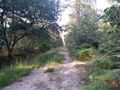
On the way 1
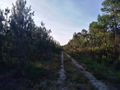
On the way 2
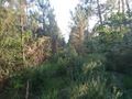
Getting very close
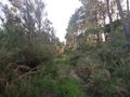
View #1 from the Geohash
View #2 from the Geohash
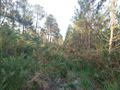
View #3 from the Geohash
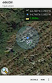
GPS proof #1
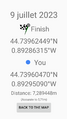
GPS proof #2


Achievements
Beltxarga earned the Land geohash achievement
|
Beltxarga earned the Bicycle geohash achievement
|