Difference between revisions of "2023-10-03 47 8"
Globescorer (talk | contribs) (Created page with "{{meetup graticule|date=2023-10-03|lat=47|lon=8}} == Location == Located on a street in a forest in the commune Öhningen, Germany. == Participants == User:globescorer|glo...") |
(Categories) |
||
| (16 intermediate revisions by 2 users not shown) | |||
| Line 13: | Line 13: | ||
will come soon... | will come soon... | ||
| + | |||
| + | -> Ähh, nope: it is all written down by the photos!... | ||
== Photos == | == Photos == | ||
| + | '''''on the swiss side of the border:''''' | ||
| + | <gallery> | ||
| + | File:2023-10-03 47 8 Stein am Rhein 2.jpg |'''[https://en.wikipedia.org/wiki/Stein_am_Rhein Stein am Rhein]''' is a very beautyful historic little town | ||
| + | File:2023-10-03 47 8 Stein am Rhein 3.jpg |over the bridge to the historic site of the town | ||
| + | File:2023-10-03 47 8 Stein am Rhein 4.jpg |other site of the bridge | ||
| + | File:2023-10-03 47 8 Stein am Rhein 1.jpg |entering the historic site | ||
| + | File:2023-10-03 47 8 Border.jpg |the border... (since the "Schengen"-contract with the EU the swiss borders mostly have not been guarded) | ||
| + | </gallery> | ||
| + | '''''on the german side:''''' | ||
<gallery> | <gallery> | ||
| − | File:2023-10-03 47 8 | + | File:2023-10-03 47 8 Oehningen.jpg |after the border first I had to drive through Öhningen... |
| − | + | File:2023-10-03 47 8 Oberer Salenhof.jpg |then I passed the farm "Oberer Salenhof" | |
| − | File:2023-10-03 47 8 | + | File:2023-10-03 47 8 Langenmoos.jpg |the hash layed on the street to the other farm "Langenmoos" |
| − | File:2023-10-03 47 8 | ||
File:2023-10-03 47 8 on the way.jpg |on the way | File:2023-10-03 47 8 on the way.jpg |on the way | ||
| − | File:2023-10-03 47 8 | + | File:2023-10-03 47 8 Proof 1.jpg |I located the hashpoint exactly on the little street without having to step out of the car! |
| + | File:2023-10-03 47 8 Proof 2.jpg |another proof (OK I stepped out for making the signs on the ground :-) | ||
</gallery> | </gallery> | ||
| + | |||
[[File:2023-10-03 47 8 Panorama.jpg|1000px]] | [[File:2023-10-03 47 8 Panorama.jpg|1000px]] | ||
<gallery> | <gallery> | ||
| − | |||
File:2023-10-03 47 8 The Geohash.jpg |The Geohash | File:2023-10-03 47 8 The Geohash.jpg |The Geohash | ||
| − | File:2023-10-03 47 8 | + | File:2023-10-03 47 8 north.jpg |view to the north |
| − | File:2023-10-03 47 8 | + | File:2023-10-03 47 8 west.jpg |view to the west |
| − | File:2023-10-03 47 8 | + | File:2023-10-03 47 8 south.jpg |view to the south |
| − | File:2023-10-03 47 8 | + | File:2023-10-03 47 8 east.jpg |view to the east |
</gallery> | </gallery> | ||
| − | + | '''''back on the swiss side of the border:''''' | |
| + | |||
<gallery> | <gallery> | ||
| − | File:2023-10-03 47 8 | + | File:2023-10-03 47 8 Stein am Rhein 5.jpg |After the visit of the hashsite I drove back to Stein am Rhein |
| − | + | File:2023-10-03 47 8 Stein am Rhein 7.jpg |There I parked and stepped down to the river Rhine for some relieve | |
| − | |||
| − | File:2023-10-03 47 8 | ||
| − | |||
| − | |||
</gallery> | </gallery> | ||
| − | [[File:2023-10-03 47 8 | + | [[File:2023-10-03 47 8 Stein am Rhein 6.jpg|1000px]] |
| + | ==Achievements== | ||
| + | {{Border geohash achievement | latitude = 47 | longitude = 8 | date = 2023-10-03 | country1= Switzerland | country2= Germany | name = globescorer |image = 2023-10-03 47 8 Border.jpg }} | ||
| + | {{Speed racer | latitude = 47 | longitude = 8 | date = 2023-10-03 | name = globescorer | speed = lower tempo for safety | image = 2023-10-03 47 8 The Geohash 2.jpg }} | ||
| + | {{land geohash|date=2023-09-05|latitude=47|longitude=8|name=[[User:globescorer|globescorer]]|image=2023-10-03 47 8 The Geohash.jpg}} | ||
| − | + | __NOTOC__ | |
| − | + | [[Category:Expeditions]] | |
| − | + | [[Category:Coordinates reached]] | |
| + | [[Category:Expeditions with photos]] | ||
| + | {{location|DE|BW|KN}} | ||
Latest revision as of 17:13, 4 October 2023
| Tue 3 Oct 2023 in 47,8: 47.6816953, 8.9313347 geohashing.info google osm bing/os kml crox |
Location
Located on a street in a forest in the commune Öhningen, Germany.
Participants
Plans
In the evening I want to reach the totays hashpoint.
Expedition
will come soon...
-> Ähh, nope: it is all written down by the photos!...
Photos
on the swiss side of the border:
Stein am Rhein is a very beautyful historic little town
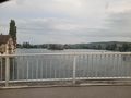
over the bridge to the historic site of the town
other site of the bridge
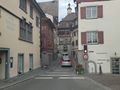
entering the historic site
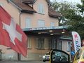
the border... (since the "Schengen"-contract with the EU the swiss borders mostly have not been guarded)


on the german side:
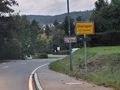
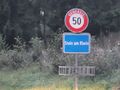
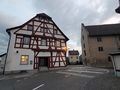
after the border first I had to drive through Öhningen...
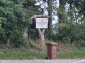
then I passed the farm "Oberer Salenhof"
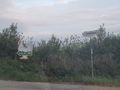
the hash layed on the street to the other farm "Langenmoos"
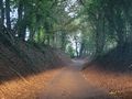
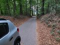
on the way

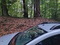
I located the hashpoint exactly on the little street without having to step out of the car!
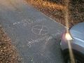
another proof (OK I stepped out for making the signs on the ground :-)


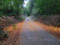
The Geohash
view to the north
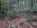
view to the west
view to the south
view to the east


back on the swiss side of the border:
After the visit of the hashsite I drove back to Stein am Rhein
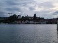
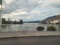
There I parked and stepped down to the river Rhine for some relieve


Achievements
globescorer earned the Border geohash achievement
|

globescorer earned the Land geohash achievement
|