2023-10-17 47 -122
| Tue 17 Oct 2023 in Seattle: 47.8120758, -122.2798473 geohashing.info google osm bing/os kml crox |
Location
Between two properties in Alderwood
Participants
Plans
Expedition
I had morning errands on the way to work and totally forgot to check the hashpoint at 6:30 am.
Errands finished, I pulled up geohashdroid and found the point to be roughly a kilometer north east of my location. Not far from a road, worth driving by and possibly stopping. With no further research, I proceeded.
Parking, I could see some sort of garden or community P-patch. In later looking at google maps, this is a property between two properties. A brook runs along the road side and then south into the property, likely between me and the hashpoint. Thomcats are notoriously bad at crossing water.
Lining up the latitude left me 10 meters short of the actual point, not a success. A large tree was east of me, and the hashpoint was likely just east of that.
I backtracked and went through the garden plots. While there were a lot of blackberries and stickers, I was able to move close to the tree. While this would be much closer to the point, the greenery overhead was distorting the signal. Eventually it settled down to under 2 meters, a success!
I shot a final photo of my car through the garden patch, then my wet sneakers and I left the expedition and continued on to work.
Tracklog
Photos
North of point @47.8122,-122.2799
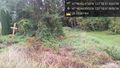
A stream runs through it @47.8122,-122.2801
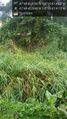
Past that tree @47.8121,-122.2800

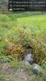
Geohasher @47.8121,-122.2798
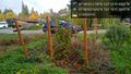
Hashcar & P patch @47.8121,-122.2798


