2023-10-26 55 -4
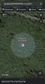
| Thu 26 Oct 2023 in 55,-4: 55.8521261, -4.6247089 geohashing.info google osm bing/os kml crox |
Location
In a field near Bridge of Weir, roughly 1.3km from the Locherwood Community Woodland Car Park.
Participants
- KerrMcF
- Daniel
Plans
After lunch, KerrMcF plans to drive to Daniel and then the Locherwood Community Woodland Car Park before walking to the point. This should be a simple journey with little to no issues.
Expedition
KerrMcF
I drove to pick Daniel up as he lives relatively near this point and had some spare time. We drove to the nearby car park and walked to the point through a few fields before heading back along the side of the road to the car park. The walk was easy although the fields were quite damp. On the walk back to the car park I found a discarded plastic bottle at the side of the road and carried this to the car park bin.
Photos
Reached the geohash
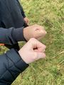
Second time dragging Daniel along
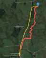
The route tracker messed up again so here's a rough route
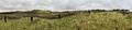
Panorama from the point (ft. 5 Daniels)
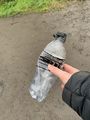
Old Pepsi Max bottle from the side of the road
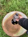
And put in its rightful place


Achievements
KerrMcF earned the Land geohash achievement
|
KerrMcF earned the Drag-along achievement
|
KerrMcF earned the GeoTrash Geohash Achievement
|