Difference between revisions of "2023-11-10 47 -122"
([live picture]Looking southeast [https://openstreetmap.org/?mlat=47.59235520&mlon=-122.22560970&zoom=16 @47.5924,-122.2256]) |
|||
| Line 18: | Line 18: | ||
== Expedition == | == Expedition == | ||
| − | + | My 5pm aim was slightly off because I needed to get some fuel. Needed is relative, of course, I might have done fine without. Anyhow, it was on the way, and reasonably priced. | |
| + | |||
| + | The trip south had the predicted amount of traffic, and I pulled off the highway on the appropriate Mercer Island exit. So far so good, except it was nearly full dark, no moon. I did my research ahead of time, though, and the point should be in a clearing with a flagpole - no underbrush! | ||
| + | |||
| + | I parked, walked, found the pole and did the hash dance. Hmm, that sentence could be misconstrued. I found the point, uploaded the picture I took and added another, then headed off to rehearsal. | ||
== Tracklog == | == Tracklog == | ||
| Line 38: | Line 42: | ||
== Achievements == | == Achievements == | ||
{{#vardefine:ribbonwidth|800px}} | {{#vardefine:ribbonwidth|800px}} | ||
| − | |||
| − | |||
| − | |||
| − | |||
| − | |||
| − | |||
| − | |||
| − | |||
| − | |||
| − | |||
| − | |||
| − | |||
| − | |||
| − | |||
[[Category:Expeditions]] | [[Category:Expeditions]] | ||
[[Category:Expeditions with photos]] | [[Category:Expeditions with photos]] | ||
[[Category:Coordinates reached]] | [[Category:Coordinates reached]] | ||
| − | |||
| − | |||
| − | |||
| − | |||
| − | |||
| − | |||
| − | |||
| − | |||
| − | |||
| − | |||
| − | |||
{{location|US|WA|KN}} | {{location|US|WA|KN}} | ||
Latest revision as of 17:57, 13 November 2023
| Fri 10 Nov 2023 in Seattle: 47.5923558, -122.2256069 geohashing.info google osm bing/os kml crox |
Location
Near a flagpole in Luther Burbank Park, Mercer Island.
Participants
Plans
Stop by after work, aiming for 5pm.
Expedition
My 5pm aim was slightly off because I needed to get some fuel. Needed is relative, of course, I might have done fine without. Anyhow, it was on the way, and reasonably priced.
The trip south had the predicted amount of traffic, and I pulled off the highway on the appropriate Mercer Island exit. So far so good, except it was nearly full dark, no moon. I did my research ahead of time, though, and the point should be in a clearing with a flagpole - no underbrush!
I parked, walked, found the pole and did the hash dance. Hmm, that sentence could be misconstrued. I found the point, uploaded the picture I took and added another, then headed off to rehearsal.
Tracklog
Photos
One stop first :) @47.7806,-122.1464
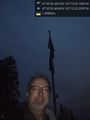
Geohasher @47.5924,-122.2256
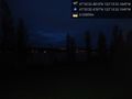
Looking southeast @47.5924,-122.2256


