Difference between revisions of "2023-11-28 52 13"
(Created page with "{{subst:Expedition}}") |
(fill with content) |
||
| Line 1: | Line 1: | ||
| − | + | [[Image:2023-11-28 52 13 3.jpg|thumb|left]] | |
| − | + | {{meetup graticule | |
| − | [[Image: | ||
| − | |||
| − | |||
| − | |||
| − | |||
| − | |||
| − | |||
| lat={{#explode:{{SUBPAGENAME}}| |1}} | | lat={{#explode:{{SUBPAGENAME}}| |1}} | ||
| lon={{#explode:{{SUBPAGENAME}}| |2}} | | lon={{#explode:{{SUBPAGENAME}}| |2}} | ||
| Line 13: | Line 6: | ||
}}<!-- edit as necessary --> | }}<!-- edit as necessary --> | ||
== Location == | == Location == | ||
| − | + | In [https://en.wikipedia.org/wiki/Barnim_Nature_Park Barnim Nature Park] near Berlin. | |
== Participants == | == Participants == | ||
| − | + | * [[User:HeNeArXn|HeNeArXn]] ([[User talk:HeNeArXn|talk]]) | |
| − | |||
== Plans == | == Plans == | ||
| − | + | Take train to Röntgental (interesting name, especially since the Buch area is kinda known for medical facilities), walk mostly through nature to location. Check a few gaps in OpenStreetMap. Succeed at first attempted Geohash. | |
== Expedition == | == Expedition == | ||
| − | + | Basically went as planned. The weather was cold but nice, the first day with proper snow this year! The area of the nature park is nice, with a nice mix of open areas and forest. Lots of info signs about the area. As a surprise, around the target location there is a network of sculpture paths: [https://de.wikipedia.org/wiki/Steine_ohne_Grenzen Steine Ohne Grenzen] – ''Stones without Borders'', which have been created at events over multiple years. This hasn't been mapped on OSM at all, and is something to return to with more time and more suitable weather to experience and document in more detail. Will need some data collecting since a bunch of the older signs have already deteriorated and are unreadable, and a lot of the smaller/flatter sculptures were covered in snow. The hash location was just off the path, a few meters from the nearest sculptures. A bit in the distance there was a group of kindergardeners sledding down a small embankment, I guess here you have to take whatever hill-like place you can find :D | |
| − | |||
| − | |||
| − | |||
== Photos == | == Photos == | ||
| − | |||
| − | |||
| − | |||
<gallery perrow="5"> | <gallery perrow="5"> | ||
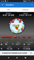
| + | Image:2023-11-28 52 13 GPS.png | GPS Location | ||
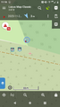
| + | Image:2023-11-28 52 13 Map.png | Map screenshot | ||
| + | Image:2023-11-28 52 13 1.jpg | My foot on the geohash point | ||
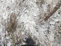
| + | Image:2023-11-28 52 13 2.jpg | View at the point | ||
| + | Image:2023-11-28 52 13 3.jpg | View at the point | ||
</gallery> | </gallery> | ||
| Line 42: | Line 33: | ||
<!-- =============== USEFUL CATEGORIES FOLLOW ================ | <!-- =============== USEFUL CATEGORIES FOLLOW ================ | ||
Delete the next line ONLY if you have chosen the appropriate categories below. If you are unsure, don't worry. People will read your report and help you with the classification. --> | Delete the next line ONLY if you have chosen the appropriate categories below. If you are unsure, don't worry. People will read your report and help you with the classification. --> | ||
| − | |||
| − | + | [[Category:Expeditions]] | |
| − | + | [[Category:Expeditions with photos]] | |
| − | |||
| − | [[Category: | ||
| − | |||
| − | |||
| − | |||
| − | |||
| − | |||
| − | |||
| − | |||
| − | |||
| − | |||
| − | |||
| − | |||
| − | |||
[[Category:Coordinates reached]] | [[Category:Coordinates reached]] | ||
| − | |||
| − | |||
| − | |||
| − | |||
| − | |||
| − | |||
| − | |||
| − | |||
| − | |||
| − | |||
| − | |||
| − | |||
| − | |||
| − | |||
| − | |||
| − | |||
| − | |||
| − | |||
Revision as of 00:36, 6 December 2023

| Tue 28 Nov 2023 in 52,13: 52.6584431, 13.4851458 geohashing.info google osm bing/os kml crox |
Location
In Barnim Nature Park near Berlin.
Participants
Plans
Take train to Röntgental (interesting name, especially since the Buch area is kinda known for medical facilities), walk mostly through nature to location. Check a few gaps in OpenStreetMap. Succeed at first attempted Geohash.
Expedition
Basically went as planned. The weather was cold but nice, the first day with proper snow this year! The area of the nature park is nice, with a nice mix of open areas and forest. Lots of info signs about the area. As a surprise, around the target location there is a network of sculpture paths: Steine Ohne Grenzen – Stones without Borders, which have been created at events over multiple years. This hasn't been mapped on OSM at all, and is something to return to with more time and more suitable weather to experience and document in more detail. Will need some data collecting since a bunch of the older signs have already deteriorated and are unreadable, and a lot of the smaller/flatter sculptures were covered in snow. The hash location was just off the path, a few meters from the nearest sculptures. A bit in the distance there was a group of kindergardeners sledding down a small embankment, I guess here you have to take whatever hill-like place you can find :D
Photos
GPS Location
Map screenshot
My foot on the geohash point
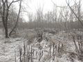
View at the point
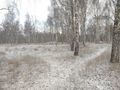
View at the point


