Difference between revisions of "2023-12-20 44 -117"
From Geohashing
Michael5000 (talk | contribs) (→Participants) |
Michael5000 (talk | contribs) (→Achievements) |
||
| (7 intermediate revisions by 2 users not shown) | |||
| Line 1: | Line 1: | ||
| − | + | {{meetup graticule | |
| − | |||
| − | |||
| − | |||
| − | |||
| − | |||
| − | |||
| − | |||
| − | |||
| lat={{#explode:{{SUBPAGENAME}}| |1}} | | lat={{#explode:{{SUBPAGENAME}}| |1}} | ||
| lon={{#explode:{{SUBPAGENAME}}| |2}} | | lon={{#explode:{{SUBPAGENAME}}| |2}} | ||
| Line 16: | Line 8: | ||
== Participants == | == Participants == | ||
| − | [[user:Michael5000|Michael5000]] | + | *[[user:Michael5000|Michael5000]] |
| − | [[user:Mrs.5000|Mrs.5000]] | + | *[[user:Mrs.5000|Mrs.5000]] |
| − | |||
| − | |||
| − | |||
== Expedition == | == Expedition == | ||
| − | + | Approaching Baker City from the north on I-84, we turned off on the "Medicine Springs Highway" and drove a few miles east to where the road starts to climb out of the Powder River Basin. The hashpoint was in sagebrush a short walk up from the road; the gate would have been a pain to unlatch and relatch twice, but it was easy enough to duck under the barbed wire. Mrs.5000 was tracking mud for a little while, but it was all worth it for some nice views and of course the thrill of reaching the hashpoint. | |
| − | |||
| − | |||
| − | |||
== Photos == | == Photos == | ||
| Line 43: | Line 29: | ||
__NOTOC__ | __NOTOC__ | ||
| − | |||
| − | |||
| − | |||
| − | |||
| − | |||
| − | |||
| − | |||
| − | |||
| − | |||
| − | |||
| − | |||
| − | |||
| − | |||
| − | |||
[[Category:Expeditions]] | [[Category:Expeditions]] | ||
| − | |||
[[Category:Expeditions with photos]] | [[Category:Expeditions with photos]] | ||
| − | |||
| − | |||
| − | |||
| − | |||
| − | |||
[[Category:Coordinates reached]] | [[Category:Coordinates reached]] | ||
| − | + | *It was the first success in the Baker City graticule for both of us (after two earlier fails for Michael5000) | |
| − | + | *For Michael5000: Ties 2023 with 2011 for most expeditions attempted (55), and makes 2023 the Best Year Ever for most successful expeditions (47). | |
| − | + | {{location|US|OR|BA}} | |
| − | |||
| − | |||
| − | |||
| − | |||
| − | |||
| − | |||
| − | |||
| − | |||
| − | |||
| − | |||
| − | |||
| − | |||
| − | |||
| − | |||
Latest revision as of 04:46, 22 December 2023
| Wed 20 Dec 2023 in 44,-117: 44.8619411, -117.7480511 geohashing.info google osm bing/os kml crox |
Location
Off of Oregon Highway 203, northeast of Baker City.
Participants
Expedition
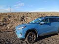
Approaching Baker City from the north on I-84, we turned off on the "Medicine Springs Highway" and drove a few miles east to where the road starts to climb out of the Powder River Basin. The hashpoint was in sagebrush a short walk up from the road; the gate would have been a pain to unlatch and relatch twice, but it was easy enough to duck under the barbed wire. Mrs.5000 was tracking mud for a little while, but it was all worth it for some nice views and of course the thrill of reaching the hashpoint.
Photos
Arriving in the vicinity
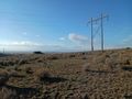
View from the hashpoint

Us, at the hashpoint
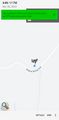
There, at the local scale
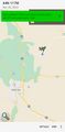
There, at the broader scale


Achievements
- It was the first success in the Baker City graticule for both of us (after two earlier fails for Michael5000)
- For Michael5000: Ties 2023 with 2011 for most expeditions attempted (55), and makes 2023 the Best Year Ever for most successful expeditions (47).