Difference between revisions of "2023-12-27 39 -111"
Michael5000 (talk | contribs) |
Michael5000 (talk | contribs) |
||
| Line 20: | Line 20: | ||
== Photos == | == Photos == | ||
<gallery perrow="5"> | <gallery perrow="5"> | ||
| − | File:2023-12-27 39 -111 a.jpg | + | File:2023-12-27 39 -111 a.jpg|Stashing the vehicle. |
| − | File:2023-12-27 39 -111 b.jpg | + | File:2023-12-27 39 -111 b.jpg|Checking out the local landscape. |
| − | File:2023-12-27 39 -111 c.jpg | + | File:2023-12-27 39 -111 c.jpg|Once we get around this monument, the way should be... |
| − | File:2023-12-27 39 -111 d.jpg | + | File:2023-12-27 39 -111 d.jpg|Oh. There's the hashpoint. Down there. |
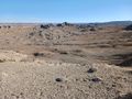
| − | File:2023-12-27 39 -111 e.jpg | + | File:2023-12-27 39 -111 e.jpg|The sheer cliffs that we did not descend. |
</gallery> | </gallery> | ||
| Line 32: | Line 32: | ||
__NOTOC__ | __NOTOC__ | ||
| − | |||
| − | |||
| − | |||
| − | |||
| − | |||
| − | |||
| − | |||
| − | |||
| − | |||
| − | |||
| − | |||
| − | |||
| − | |||
| − | |||
[[Category:Expeditions]] | [[Category:Expeditions]] | ||
| − | |||
[[Category:Expeditions with photos]] | [[Category:Expeditions with photos]] | ||
| − | |||
| − | |||
| − | |||
| − | |||
| − | |||
| − | |||
| − | |||
| − | |||
| − | |||
[[Category:Coordinates not reached]] | [[Category:Coordinates not reached]] | ||
| − | |||
| − | |||
[[Category:Not reached - Mother Nature]] | [[Category:Not reached - Mother Nature]] | ||
| − | |||
| − | |||
| − | |||
| − | |||
| − | |||
| − | |||
| − | |||
| − | |||
| − | |||
| − | |||
| − | |||
Revision as of 02:40, 28 December 2023
| Wed 27 Dec 2023 in 39,-111: 39.0844079, -111.1766645 geohashing.info google osm bing/os kml crox |
Location
A few miles west of Ferron.
Participants
Expedition
After 2023-12-27 39 -109, we continued west across the boring part of I-70, and then across the spectacular part of I-70, and then through the Eagle Canyon on the Moore Cutoff Road to catch Utah Highway 10. That got us to Ferron, and we parked the expedition vehicle about 1000 meters from the hashpoint.
A dirt track seemed pretty promising at first, then seemed to be dead-ending, then swooped around some fences and broke back towards the hashpoint. At about 500 meters out, we skirted around the cold, shady north end of an enormous monument rock, and after that it looked like there were no more obstacles between us and the hashpoint. We marched confidently along, until rather suddenly we came up over a modest rise, and the ground disappeared a few meters beneath us. We were on top of a sheer cliff! Although the hashpoint was clearly visible below us, it might as well have been on the moon for us to be able to get to it.
Further exploration confirmed that there was no remotely safe way down the cliff, and since we already knew that the other approaches to the hashpoint were blocked by private land, we declared the expedition a memorable failure. We went and consoled ourselves by checking out candidate for the world's largest organism.
Photos
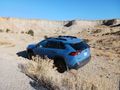
Stashing the vehicle.
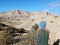
Checking out the local landscape.
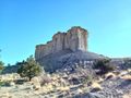
Once we get around this monument, the way should be...
Oh. There's the hashpoint. Down there.
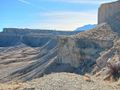
The sheer cliffs that we did not descend.


