Difference between revisions of "2023-12-28 39 -111"
Michael5000 (talk | contribs) (→Participants) |
Michael5000 (talk | contribs) |
||
| Line 1: | Line 1: | ||
| − | + | {{meetup graticule | |
| − | |||
| − | |||
| − | |||
| − | |||
| − | |||
| − | |||
| − | |||
| − | |||
| lat={{#explode:{{SUBPAGENAME}}| |1}} | | lat={{#explode:{{SUBPAGENAME}}| |1}} | ||
| lon={{#explode:{{SUBPAGENAME}}| |2}} | | lon={{#explode:{{SUBPAGENAME}}| |2}} | ||
| Line 19: | Line 11: | ||
*[[user:Mrs.5000|Mrs.5000]] | *[[user:Mrs.5000|Mrs.5000]] | ||
| − | == | + | == Expedition == |
| − | + | After [[2023-12-27 39 -111|yesterday's failed expedition to the Nephi graticule]] -- Michael5000's second in three months -- we eventually ended up spending the night in Richfield, Utah. Morning brought a new set of hashpoints (as it will do), including this one not far from our intended route back to the north. So it is that Michael took a third shot at Nephi. | |
| − | + | A gravel road off of US Highway 89 led over a line of hills and then dove down into a dry, quiet valley. A few miles of driving brought us to within a short walk of the hashpoint, and a break in the fenceline made it easy to get the rest of the way. We could see a long way in every direction, and we were the only people in the landscape. | |
| − | + | ||
| + | Back to the vehicle, back to the highway, and soon we were on our way north and west for a long day's drive to [[2023-12-28 42 -114]]. | ||
| − | |||
| − | |||
== Photos == | == Photos == | ||
| − | |||
| − | |||
| − | |||
<gallery perrow="5"> | <gallery perrow="5"> | ||
| + | File:2023-12-28 39 -111 a.jpg|Descending into the valley | ||
| + | File:2023-12-28 39 -111 b.jpg|Deploying the landing party | ||
| + | File:2023-12-28 39 -111 c.jpg|Conveniently damaged fencing | ||
| + | File:2023-12-28 39 -111 d.jpg|Winners of the anthill potato award | ||
| + | File:2023-12-28 39 -111 e.jpg|Our victory photograph | ||
| + | File:2023-12-28 39 -111 f.jpg|View south from the hashpoint | ||
| + | File:2023-12-28 39 -111 g.jpg|Lots of thorns to get out of shoes and socks afterwards | ||
| + | File:2023-12-28 39 -111 h.jpg| | ||
</gallery> | </gallery> | ||
== Achievements == | == Achievements == | ||
{{#vardefine:ribbonwidth|100%}} | {{#vardefine:ribbonwidth|100%}} | ||
| − | + | *A new graticule for a successful expedition for both of us. | |
__NOTOC__ | __NOTOC__ | ||
| − | |||
| − | |||
| − | |||
| − | |||
| − | |||
| − | |||
| − | |||
| − | |||
| − | |||
| − | |||
| − | |||
| − | |||
| − | |||
| − | |||
[[Category:Expeditions]] | [[Category:Expeditions]] | ||
| − | |||
[[Category:Expeditions with photos]] | [[Category:Expeditions with photos]] | ||
| − | |||
| − | |||
| − | |||
| − | |||
| − | |||
[[Category:Coordinates reached]] | [[Category:Coordinates reached]] | ||
| − | |||
| − | |||
| − | |||
| − | |||
| − | |||
| − | |||
| − | |||
| − | |||
| − | |||
| − | |||
| − | |||
| − | |||
| − | |||
| − | |||
| − | |||
| − | |||
| − | |||
| − | |||
Revision as of 05:10, 29 December 2023
| Thu 28 Dec 2023 in 39,-111: 39.2151122, -111.7317710 geohashing.info google osm bing/os kml crox |
Location
In a valley northeast of Gunnison, Utah.
Participants
Expedition
After yesterday's failed expedition to the Nephi graticule -- Michael5000's second in three months -- we eventually ended up spending the night in Richfield, Utah. Morning brought a new set of hashpoints (as it will do), including this one not far from our intended route back to the north. So it is that Michael took a third shot at Nephi.
A gravel road off of US Highway 89 led over a line of hills and then dove down into a dry, quiet valley. A few miles of driving brought us to within a short walk of the hashpoint, and a break in the fenceline made it easy to get the rest of the way. We could see a long way in every direction, and we were the only people in the landscape.
Back to the vehicle, back to the highway, and soon we were on our way north and west for a long day's drive to 2023-12-28 42 -114.
Photos
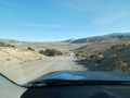
Descending into the valley
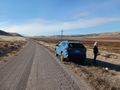
Deploying the landing party
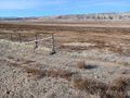
Conveniently damaged fencing
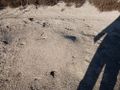
Winners of the anthill potato award
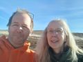
Our victory photograph
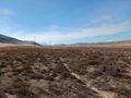
View south from the hashpoint
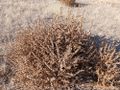
Lots of thorns to get out of shoes and socks afterwards


Achievements
- A new graticule for a successful expedition for both of us.