Difference between revisions of "2023-12-31 45 -120"
Michael5000 (talk | contribs) (→Photos) |
Michael5000 (talk | contribs) |
||
| Line 1: | Line 1: | ||
| − | + | {{meetup graticule | |
| − | |||
| − | |||
| − | |||
| − | |||
| − | |||
| − | |||
| − | |||
| − | |||
| lat={{#explode:{{SUBPAGENAME}}| |1}} | | lat={{#explode:{{SUBPAGENAME}}| |1}} | ||
| lon={{#explode:{{SUBPAGENAME}}| |2}} | | lon={{#explode:{{SUBPAGENAME}}| |2}} | ||
| Line 19: | Line 11: | ||
*[[user:Mrs.5000|Mrs.5000]] | *[[user:Mrs.5000|Mrs.5000]] | ||
| − | == | + | == Expedition == |
| − | + | [[2023-05-01 45 -119|Earlier this year]], Michael5000 ran into a number of challenges trying to reach a hashpoint on the way home from Baker City. This time, things went a little smoother. | |
| − | + | Roughly halfway home, we took the Arlington exit, went south 8 or 9 miles, then turned west on the road that goes past the sprawling landfill operation. We passed within a few meters of [[2022-07-08 45 -120]], and not much further from [[2019-06-05 45 -120]], but continued a little further this time. Where Blalock Canyon Road and Cedar Springs Lane there's a bit of a pad that we could park at, and from there it was just a couple of hundred meters to the hashpoint. The most remarkable nearby feature was a bright blue thing, roughly the size and shape of a barrel, that had been extensively used for target practice. The scenery in general was grand -- I'm used to this part of the world being golden-yellow in its extensive dry season, but it turns out that it's kind of a moss green in winter. | |
| − | |||
| − | + | Afterwards, we made it home! | |
| − | |||
== Photos == | == Photos == | ||
| Line 44: | Line 34: | ||
__NOTOC__ | __NOTOC__ | ||
| − | |||
| − | |||
| − | |||
| − | |||
| − | |||
| − | |||
| − | |||
| − | |||
| − | |||
| − | |||
| − | |||
| − | |||
| − | |||
[[Category:Expeditions]] | [[Category:Expeditions]] | ||
| − | |||
[[Category:Expeditions with photos]] | [[Category:Expeditions with photos]] | ||
| − | |||
| − | |||
| − | |||
| − | |||
| − | |||
[[Category:Coordinates reached]] | [[Category:Coordinates reached]] | ||
| − | |||
| − | |||
| − | |||
| − | |||
| − | |||
| − | |||
| − | |||
| − | |||
| − | |||
| − | |||
| − | |||
| − | |||
| − | |||
| − | |||
| − | |||
| − | |||
| − | |||
| − | |||
Revision as of 04:47, 1 January 2024
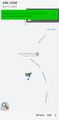
| Sun 31 Dec 2023 in 45,-120: 45.5988040, -120.2919734 geohashing.info google osm bing/os kml crox |
Location
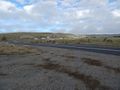
Near the intersection of Blalock Canyon Road and Cedar Springs Lane.
Participants
Expedition
Earlier this year, Michael5000 ran into a number of challenges trying to reach a hashpoint on the way home from Baker City. This time, things went a little smoother.
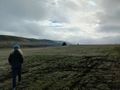
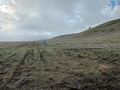
Roughly halfway home, we took the Arlington exit, went south 8 or 9 miles, then turned west on the road that goes past the sprawling landfill operation. We passed within a few meters of 2022-07-08 45 -120, and not much further from 2019-06-05 45 -120, but continued a little further this time. Where Blalock Canyon Road and Cedar Springs Lane there's a bit of a pad that we could park at, and from there it was just a couple of hundred meters to the hashpoint. The most remarkable nearby feature was a bright blue thing, roughly the size and shape of a barrel, that had been extensively used for target practice. The scenery in general was grand -- I'm used to this part of the world being golden-yellow in its extensive dry season, but it turns out that it's kind of a moss green in winter.
Afterwards, we made it home!
Photos
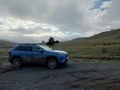
Arriving in the vicinity
Mrs.5000 sets out
view south from the hashpoint
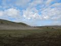
view northwest
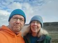
celebratory
A nearby ranch