Difference between revisions of "2024-01-11 58 5"
From Geohashing
(→Photos) |
(→Participants) |
||
| (5 intermediate revisions by the same user not shown) | |||
| Line 23: | Line 23: | ||
*[[User:Pica42|Pica42]] | *[[User:Pica42|Pica42]] | ||
| + | * pica42's wife | ||
== Plans == | == Plans == | ||
| Line 29: | Line 30: | ||
== Expedition == | == Expedition == | ||
<!-- how it all turned out. your narrative goes here. --> | <!-- how it all turned out. your narrative goes here. --> | ||
| + | |||
| + | The trip to find today's geohash was a drive of approx 60 km each way. The weather was nice and it was a great trip. I took the opportunity to also find some Munzee. | ||
== Tracklog == | == Tracklog == | ||
| Line 43: | Line 46: | ||
Image:20240111 58 5 E-2.jpg|thumb|View to the east | Image:20240111 58 5 E-2.jpg|thumb|View to the east | ||
Image:20240111 58 5 N-2.jpg|thumb|View to the north | Image:20240111 58 5 N-2.jpg|thumb|View to the north | ||
| − | + | Image:20240111 58 5 W-2.jpg|thumb|View to the west | |
</gallery> | </gallery> | ||
| Line 50: | Line 53: | ||
<!-- Add any achievement ribbons you earned below, or remove this section --> | <!-- Add any achievement ribbons you earned below, or remove this section --> | ||
| − | + | {{land geohash |name=[[User:Pica42|Pica42]] |date=2024-01-11 |latitude=58 |longitude=5 }} | |
| − | |||
| − | |||
| − | [[ | ||
| − | |||
| − | |||
| − | |||
| − | |||
| − | |||
| − | |||
| − | |||
| − | |||
| − | |||
| − | |||
| − | |||
[[Category:Expeditions]] | [[Category:Expeditions]] | ||
| − | |||
[[Category:Expeditions with photos]] | [[Category:Expeditions with photos]] | ||
| − | |||
| − | |||
| − | |||
| − | |||
| − | |||
[[Category:Coordinates reached]] | [[Category:Coordinates reached]] | ||
| + | {{location|NO|11}} | ||
| − | + | __NOTOC__ | |
| − | |||
| − | |||
| − | |||
| − | |||
| − | |||
| − | |||
| − | |||
| − | |||
| − | |||
| − | |||
| − | |||
| − | |||
| − | |||
| − | |||
| − | |||
Latest revision as of 19:06, 14 January 2024
| Thu 11 Jan 2024 in 58,5: 58.4537326, 5.9192272 geohashing.info google osm bing/os kml crox |

Location
Near Skadberg, Eigerøy in Egersund, Norway
Participants
- Pica42
- pica42's wife
Plans
Expedition
The trip to find today's geohash was a drive of approx 60 km each way. The weather was nice and it was a great trip. I took the opportunity to also find some Munzee.
Tracklog
Photos

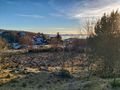
Skadberg @58.4538,5.9193
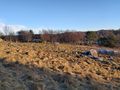
View to the south
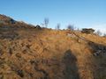
View to the east
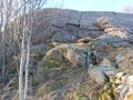
View to the north
View to the west


Achievements
Pica42 earned the Land geohash achievement
|