Difference between revisions of "2024-01-12 58 5"
From Geohashing
(→Participants) |
|||
| (18 intermediate revisions by 2 users not shown) | |||
| Line 10: | Line 10: | ||
| lat=58 | | lat=58 | ||
| lon=5 | | lon=5 | ||
| − | | date=2024-01- | + | | date=2024-01-12 |
}}<!-- edit as necessary --> | }}<!-- edit as necessary --> | ||
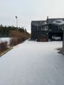
| − | + | [[Image:20240112 142209.jpg|thumb|left]] | |
== Location == | == Location == | ||
<!-- where you've surveyed the hash to be --> | <!-- where you've surveyed the hash to be --> | ||
| − | + | On top of Bogafjell, Sandnes, Norway | |
== Participants == | == Participants == | ||
| Line 23: | Line 23: | ||
*[[User:Pica42|Pica42]] | *[[User:Pica42|Pica42]] | ||
| + | * pica42's wife | ||
== Plans == | == Plans == | ||
| Line 30: | Line 31: | ||
<!-- how it all turned out. your narrative goes here. --> | <!-- how it all turned out. your narrative goes here. --> | ||
| − | + | On this day, it was a short walk from the nearest car park to the geohash point. | |
== Tracklog == | == Tracklog == | ||
| Line 40: | Line 41: | ||
--> | --> | ||
<gallery perrow="5"> | <gallery perrow="5"> | ||
| + | Image:20240112-142059_nye.jpg|Bogafjell [https://openstreetmap.org/?mlat=58.4537326&mlon=5.9192272&zoom=16 @58.4537,5.9192] | ||
| + | Image:20240112 142220 NE.jpg|thumb|View to the northeast | ||
| + | Image:20240112 142225 NW.jpg|thumb|View to the northwest | ||
| + | Image:20240112 142228 SW.jpg|thumb|View to the southwest | ||
| + | Image:20240112 142222 SE.jpg|thumb|View to the southeast | ||
</gallery> | </gallery> | ||
| Line 47: | Line 53: | ||
<!-- Add any achievement ribbons you earned below, or remove this section --> | <!-- Add any achievement ribbons you earned below, or remove this section --> | ||
| − | {{land geohash |name=[[User:Pica42|Pica42]] |date=2024-01- | + | {{land geohash |name=[[User:Pica42|Pica42]] |date=2024-01-12 |latitude=58 |longitude=5 }} |
[[Category:Expeditions]] | [[Category:Expeditions]] | ||
[[Category:Expeditions with photos]] | [[Category:Expeditions with photos]] | ||
Latest revision as of 19:05, 14 January 2024
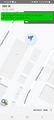
| Fri 12 Jan 2024 in 58,5: 58.8131277, 5.7481457 geohashing.info google osm bing/os kml crox |

Location
On top of Bogafjell, Sandnes, Norway
Participants
- Pica42
- pica42's wife
Plans
Expedition
On this day, it was a short walk from the nearest car park to the geohash point.
Tracklog
Photos
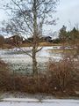
Bogafjell @58.4537,5.9192
View to the northeast
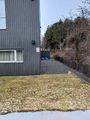
View to the northwest
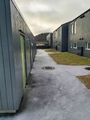
View to the southwest
View to the southeast


Achievements
Pica42 earned the Land geohash achievement
|