Difference between revisions of "2024-01-23 47 8"
Globescorer (talk | contribs) (→Expedition) |
m (Location) |
||
| (4 intermediate revisions by 2 users not shown) | |||
| Line 11: | Line 11: | ||
==Expedition== | ==Expedition== | ||
| − | + | This evening I drove to pretty much the northernmost point of Switzerland to this geohash. It is about 60m from the border with Germany. | |
| − | + | The coordinates were in a planted field. Luckily, I was able to follow the tractor tracks until a few meters close to the geohash. GeohashDroid was happy and showed green. | |
| + | |||
| + | I took my fotos and proofs an left the swampy field. At the border I was able to discover some old, large border stones. | ||
| + | |||
| + | Tomorrow would be my first hashiversary, but unfortunately the coordinates aren't reachable for me because of not having enough time.. | ||
==Fotos== | ==Fotos== | ||
| Line 29: | Line 33: | ||
</gallery> | </gallery> | ||
| + | |||
| + | __NOTOC__ | ||
| + | [[Category:Expeditions]] | ||
| + | [[Category:Expeditions with photos]] | ||
| + | [[Category:Coordinates reached]] | ||
| + | {{location|CH|SH}} | ||
Latest revision as of 22:42, 23 January 2024
| Tue 23 Jan 2024 in 47,8: 47.7823475, 8.6811072 geohashing.info google osm bing/os kml crox |
Location
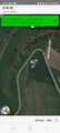
This Geohash is located in a field near Hofen (SH), Switzerland.
Participants
Plans
To drive to the coordinates in the evening.
Expedition
This evening I drove to pretty much the northernmost point of Switzerland to this geohash. It is about 60m from the border with Germany.
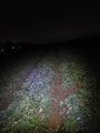
The coordinates were in a planted field. Luckily, I was able to follow the tractor tracks until a few meters close to the geohash. GeohashDroid was happy and showed green.
I took my fotos and proofs an left the swampy field. At the border I was able to discover some old, large border stones.
Tomorrow would be my first hashiversary, but unfortunately the coordinates aren't reachable for me because of not having enough time..
Fotos
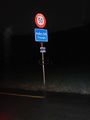
leaving Hofen
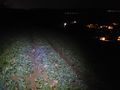
south
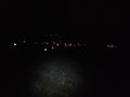
west
north
The Proof
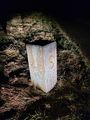
boundary stone on the Swiss side (S = Schweiz)
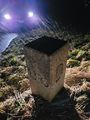
boundary stone on the German side (D = Deutschland)


