Difference between revisions of "2024-02-13 47 11"
(Created page with "{{subst:Expedition |TOC = f |show_location = t |location = a bit south of Starnberg See |show_participants = t |participants = Osmium |show_plans = t |plan...") |
m (Location correction) |
||
| (5 intermediate revisions by 2 users not shown) | |||
| Line 13: | Line 13: | ||
}}<!-- edit as necessary --> | }}<!-- edit as necessary --> | ||
== Location == | == Location == | ||
| − | a bit south of Starnberg See | + | In a forest a bit south of Starnberg See |
== Participants == | == Participants == | ||
| Line 19: | Line 19: | ||
== Plans == | == Plans == | ||
| − | Planing on getting there at some point in the afternoon, maybe have a cup of tea and some biscuits | + | Planing on getting there at some point in the afternoon, maybe have a cup of tea and some biscuits. |
== Expedition == | == Expedition == | ||
| + | I planed on taking the S-Bahn to Tutzing and then biking the rest of the way, but the on I took had to stop at Starnberg, so decided to from there by bike instead of waiting for the next train to Tutzing. | ||
| + | The bike path along the lake were quite nice, especially when the sun poked out of the clouds. | ||
| + | Once I got to the forest south of Seeshaupt the path became a bit steeper which did slow progress a bit. The few wrong turns I took probably also played a part in that. | ||
| + | |||
| + | Finally manage to reach the hash just before 5 pm. | ||
| + | |||
| + | Had a few minutes of rest, had some tea and biscuit, as planed. Then had to head back to return home before dark. | ||
== Photos == | == Photos == | ||
| Line 30: | Line 37: | ||
--> | --> | ||
<gallery perrow="5"> | <gallery perrow="5"> | ||
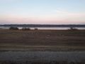
| + | 2024-02-13 47 11 path along the lake.jpg|The path along the lake on my way there | ||
| + | 2024-02-13 47 11 It's there.jpg|Finally arrived to the hash point | ||
| + | 2024-02-13 47 11 proof.jpg|Proof | ||
| + | 2024-02-13 47 11 tea & biscuit.jpg|Tea and biscuit | ||
| + | 2024-02-13 47 11 the path return.jpg|The path at dusk during the return trip | ||
</gallery> | </gallery> | ||
| − | |||
__NOTOC__ | __NOTOC__ | ||
| − | |||
| − | |||
| − | |||
| − | |||
| − | |||
| − | |||
| − | |||
| − | |||
| − | |||
| − | |||
| − | |||
| − | |||
| − | |||
[[Category:Expeditions]] | [[Category:Expeditions]] | ||
| − | + | [[Category:Expeditions with photos]] | |
| − | [[Category:Expeditions with photos]] | ||
| − | |||
| − | |||
| − | |||
| − | |||
| − | |||
[[Category:Coordinates reached]] | [[Category:Coordinates reached]] | ||
| − | + | {{location|DE|BY|WM}} | |
| − | |||
| − | |||
| − | |||
| − | |||
| − | |||
| − | |||
| − | |||
| − | |||
| − | |||
| − | |||
| − | |||
| − | |||
| − | |||
| − | |||
| − | |||
| − | |||
| − | |||
Latest revision as of 04:52, 15 February 2024
| Tue 13 Feb 2024 in 47,11: 47.7912502, 11.2711300 geohashing.info google osm bing/os kml crox |
Location
In a forest a bit south of Starnberg See
Participants
Plans
Planing on getting there at some point in the afternoon, maybe have a cup of tea and some biscuits.
Expedition
I planed on taking the S-Bahn to Tutzing and then biking the rest of the way, but the on I took had to stop at Starnberg, so decided to from there by bike instead of waiting for the next train to Tutzing.
The bike path along the lake were quite nice, especially when the sun poked out of the clouds. Once I got to the forest south of Seeshaupt the path became a bit steeper which did slow progress a bit. The few wrong turns I took probably also played a part in that.
Finally manage to reach the hash just before 5 pm.
Had a few minutes of rest, had some tea and biscuit, as planed. Then had to head back to return home before dark.
Photos
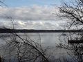
The path along the lake on my way there
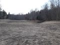
Finally arrived to the hash point
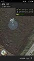
Proof
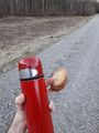
Tea and biscuit
The path at dusk during the return trip


