Difference between revisions of "2024-02-13 51 5"
From Geohashing
MyrtleGlacy (talk | contribs) |
m (Location) |
||
| (2 intermediate revisions by one other user not shown) | |||
| Line 1: | Line 1: | ||
| − | + | {{meetup graticule|lat=51|lon=5|date=2024-02-13}} | |
| − | |||
| − | |||
| − | |||
| − | |||
| − | |||
| − | |||
| − | |||
| − | |||
| − | | lat= | ||
| − | | lon= | ||
| − | | date= | ||
| − | |||
== Location == | == Location == | ||
<!-- where you've surveyed the hash to be --> | <!-- where you've surveyed the hash to be --> | ||
| Line 17: | Line 5: | ||
== Participants == | == Participants == | ||
| − | + | *[[User:MyrtleGlacy|MyrtleGlacy]] | |
| − | |||
| − | |||
| − | [[User:MyrtleGlacy|MyrtleGlacy]] | ||
| − | |||
| − | |||
| − | |||
== Expedition == | == Expedition == | ||
| Line 29: | Line 11: | ||
Finally, during a week's off of work, I saw a hash near me that I could reach. Took a bus and a train to get close, then walked the rest of the way. Not a very eventful trip, but the weather only improved while walking which was nice. | Finally, during a week's off of work, I saw a hash near me that I could reach. Took a bus and a train to get close, then walked the rest of the way. Not a very eventful trip, but the weather only improved while walking which was nice. | ||
| − | |||
| − | |||
| − | |||
== Photos == | == Photos == | ||
| Line 38: | Line 17: | ||
--> | --> | ||
<gallery perrow="5"> | <gallery perrow="5"> | ||
| − | + | 2024-02-13 51 5 Crossing.jpeg|took a while to finally cross to the right side | |
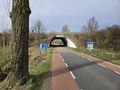
| − | + | 2024-02-13 51 5 Exit.jpeg|Had to leave town | |
| − | + | 2024-02-13 51 5 Nothing around.jpeg|nothing noteworthy about the hash | |
| − | + | 2024-02-13 51 5 Selfie Time.jpeg|Hot stuff | |
| − | + | 2024-02-13 51 5 Screenshot.jpeg|proof of reaching the hash | |
| − | + | 2024-02-13 51 5 Entry back.jpeg|returning to civilization on the way back | |
</gallery> | </gallery> | ||
| Line 52: | Line 31: | ||
{{Public transport geohash | {{Public transport geohash | ||
| − | | latitude = 51 | + | | latitude = 51 |
| − | | longitude = 5 | + | | longitude = 5 |
| date = 2024-02-13 | | date = 2024-02-13 | ||
| busline = Bus 73 en NS sprinter naar Zaltbommel | | busline = Bus 73 en NS sprinter naar Zaltbommel | ||
| Line 63: | Line 42: | ||
{{land geohash | {{land geohash | ||
| − | | latitude = 51 | + | | latitude = 51 |
| − | | longitude = 5 | + | | longitude = 5 |
| − | | date = 2024-02- | + | | date = 2024-02-13 |
| name = MyrtleGlacy | | name = MyrtleGlacy | ||
| image = 2024-02-13 51 5 Selfie Time.jpeg | | image = 2024-02-13 51 5 Selfie Time.jpeg | ||
| Line 72: | Line 51: | ||
__NOTOC__ | __NOTOC__ | ||
| − | |||
| − | |||
| − | |||
| − | |||
| − | |||
| − | |||
| − | |||
| − | |||
| − | |||
| − | |||
| − | |||
| − | |||
| − | |||
| − | |||
[[Category:Expeditions]] | [[Category:Expeditions]] | ||
| − | |||
[[Category:Expeditions with photos]] | [[Category:Expeditions with photos]] | ||
| − | |||
| − | |||
| − | |||
| − | |||
| − | |||
[[Category:Coordinates reached]] | [[Category:Coordinates reached]] | ||
| − | + | {{location|NL|GE}} | |
| − | |||
| − | |||
| − | |||
| − | |||
| − | |||
| − | |||
| − | |||
| − | |||
| − | |||
| − | |||
| − | |||
| − | |||
| − | |||
| − | |||
| − | |||
| − | |||
| − | |||
Latest revision as of 08:43, 14 February 2024
| Tue 13 Feb 2024 in 51,5: 51.7912502, 5.2711300 geohashing.info google osm bing/os kml crox |
Location
Just below Zaltbommel on an open road.
Participants
Expedition
Finally, during a week's off of work, I saw a hash near me that I could reach. Took a bus and a train to get close, then walked the rest of the way. Not a very eventful trip, but the weather only improved while walking which was nice.
Photos
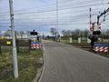
took a while to finally cross to the right side
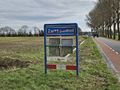
Had to leave town
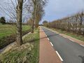
nothing noteworthy about the hash

Hot stuff
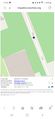
proof of reaching the hash
returning to civilization on the way back


Achievements
MyrtleGlacy earned the Public transport geohash achievement
|
MyrtleGlacy earned the Land geohash achievement
|