Difference between revisions of "2024-02-16 32 -109"
Michael5000 (talk | contribs) (→Location) |
m (per Renaming Proposal) |
||
| (5 intermediate revisions by 2 users not shown) | |||
| Line 16: | Line 16: | ||
== Participants == | == Participants == | ||
| − | + | *[[user:Michael5000|Michael5000]] | |
| − | |||
| − | |||
| − | |||
| − | |||
== Expedition == | == Expedition == | ||
| − | + | After flying to Phoenix last Sunday and nabbing [[2024-02-11 33 -112|that day's local hashpoint]], I spent a week doing software training things. When my class ended today, I headed south to Tucson, then continued east on I-10 as far as the small desert town of Willcox. From there, State Road 186 headed south across the flats and then into some hills, through a tiny village with the delightful name of Dos Cabezas, and on to where I turned left onto Apache Pass Road. | |
| − | + | It's a dirt road, but I'd found a website earlier in the day that had promised that it was "suitable for passenger cars for its entire length," and that certainly proved true for its westmost five miles. I only saw two other vehicles using it, both of which passed me at the hashpoint with the drivers giving me puzzled glances: what a random, remote, not-particularly-scenic place to stop. Well, that's geohashing for you. | |
| − | |||
== Photos == | == Photos == | ||
<gallery perrow="5"> | <gallery perrow="5"> | ||
| − | File:2024-02-16 32 -109 | + | File:2024-02-16 32 -109 c.jpg|Pulling to the side of Apache Pass Road |
| − | File:2024-02-16 32 -109 | + | File:2024-02-16 32 -109 b.jpg|A yucca plant in the center foreground lives at the hashpoint |
| − | File:2024-02-16 32 -109 d.jpg | + | File:2024-02-16 32 -109 d.jpg|Back at the intersection with Arizona 186 |
File:2024-02-16 32 -109 e.jpg | File:2024-02-16 32 -109 e.jpg | ||
</gallery> | </gallery> | ||
| Line 38: | Line 33: | ||
== Achievements == | == Achievements == | ||
{{#vardefine:ribbonwidth|100%}} | {{#vardefine:ribbonwidth|100%}} | ||
| − | + | {{Graticule unlocked | |
| − | + | | latitude = 32 | |
| − | + | | longitude = -109 | |
| − | + | | date = 2024-02-16 | |
| − | + | | name = Michael5000 | |
| − | + | }} | |
| − | + | __NOTOC__ | |
| − | |||
| − | |||
| − | |||
| − | |||
| − | |||
| − | |||
| − | |||
[[Category:Expeditions]] | [[Category:Expeditions]] | ||
| − | |||
[[Category:Expeditions with photos]] | [[Category:Expeditions with photos]] | ||
| − | |||
| − | |||
| − | |||
| − | |||
| − | |||
[[Category:Coordinates reached]] | [[Category:Coordinates reached]] | ||
| − | + | {{location|US|AZ|CH}} | |
| − | |||
| − | |||
| − | |||
| − | |||
| − | |||
| − | |||
| − | |||
| − | |||
| − | |||
| − | |||
| − | |||
| − | |||
| − | |||
| − | |||
| − | |||
| − | |||
| − | |||
Latest revision as of 04:37, 20 March 2024
| Fri 16 Feb 2024 in 32,-109: 32.1421274, -109.4907922 geohashing.info google osm bing/os kml crox |
Location
Off Apache Pass Road, south of Bowie.
Participants
Expedition
After flying to Phoenix last Sunday and nabbing that day's local hashpoint, I spent a week doing software training things. When my class ended today, I headed south to Tucson, then continued east on I-10 as far as the small desert town of Willcox. From there, State Road 186 headed south across the flats and then into some hills, through a tiny village with the delightful name of Dos Cabezas, and on to where I turned left onto Apache Pass Road.
It's a dirt road, but I'd found a website earlier in the day that had promised that it was "suitable for passenger cars for its entire length," and that certainly proved true for its westmost five miles. I only saw two other vehicles using it, both of which passed me at the hashpoint with the drivers giving me puzzled glances: what a random, remote, not-particularly-scenic place to stop. Well, that's geohashing for you.
Photos
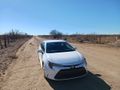
Pulling to the side of Apache Pass Road
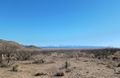
A yucca plant in the center foreground lives at the hashpoint
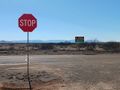
Back at the intersection with Arizona 186


Achievements
Michael5000 earned the Graticule Unlocked Achievement
|