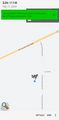
2024-02-17 32 -111
| Sat 17 Feb 2024 in 32,-111: 32.0860456, -111.2671463 geohashing.info google osm bing/os kml crox |
Location
In the desert west of Tucson.
Participants
Expedition
So after 2024-02-16 32 -109, I returned to Tucson, had dinner at a restaurant with great service and terrible food even by my standards, and slept like a stone.
This morning, I woke up early, had breakfast at a chain restaurant with terrible service but surprisingly good food, and made my way south to Nogales for the first arbitrary-travel adventure of the day: collecting my final Arizona county! After poking around that border town for a while, I made my way back to Tucsan by an alternate route and then immediately left again, this time westbound towards this hashpoint.
The gate to this parcel of land south of Arizona Highway 86 and west of Sierrita Mountain Road has long since been down -- its barbed wire is rusting into the dirt -- so it was simple matter of parking and walking in to the hashpoint. It's true desert territory, with lots of cactus but plenty of space in between them for the casual walker. There were a few of the classic saguaro cacti around, the kind of cactus you see in the cartoons, but not as many as on the hills closer in to Tucson, where there are regular cartoon forests of them.
Photos

Me, at hashpoint
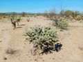
View from hashpoint
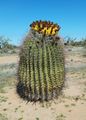
Cactus, not exactly at hashpoint but quite handsome