Difference between revisions of "2024-02-18 -35 138"
m (minesweeper, i guess) |
m (forgot these two edits) |
||
| Line 14: | Line 14: | ||
== Location == | == Location == | ||
<!-- where you've surveyed the hash to be --> | <!-- where you've surveyed the hash to be --> | ||
| + | A firetrack near Mount Barker | ||
== Participants == | == Participants == | ||
| Line 62: | Line 63: | ||
<!-- =============== USEFUL CATEGORIES FOLLOW ================ | <!-- =============== USEFUL CATEGORIES FOLLOW ================ | ||
Delete the next line ONLY if you have chosen the appropriate categories below. If you are unsure, don't worry. People will read your report and help you with the classification. --> | Delete the next line ONLY if you have chosen the appropriate categories below. If you are unsure, don't worry. People will read your report and help you with the classification. --> | ||
| − | |||
<!-- ==REQUEST FOR TWITTER BOT== Please leave either the New report or the Expedition planning category in as long as you work on it. This helps the twitter bot a lot with announcing the right outcome at the right moment. --> | <!-- ==REQUEST FOR TWITTER BOT== Please leave either the New report or the Expedition planning category in as long as you work on it. This helps the twitter bot a lot with announcing the right outcome at the right moment. --> | ||
Revision as of 01:18, 21 February 2024
| Sun 18 Feb 2024 in -35,138: -35.1123376, 138.8348436 geohashing.info google osm bing/os kml crox |
Location
A firetrack near Mount Barker
Participants
XXOs's dad
Plans
The reasoning for doing this geohash was basically the same as my last one - I still need more (night) hours for my driver's license, and again my father was available and the geohash was (probably) accessible.
Expedition
The drive to this hashpoint was slightly more eventful than last time! By which I mean there were roadworks on the South Eastern Freeway, and so I had to travel at 40km/h rather than the usual 80-100km/h.
After a little under an hour of driving, we reached the hashpoint. Well, almost. The point was about 200 metres down a fire track which we weren't allowed to drive down, so we had to walk the last stretch. It wasn't too bad, but my dad was wearing sandals (not the best walking shoes) and there was an annoying amount of bugs.
I almost didn't reach the hash, as it was very slightly on someone's property, but it was close enough to the fence that I could successfully claim it.
Photos
(I've figured out how to keep the photo metadata from my phone this time)
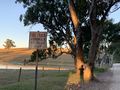
Start of the firetrack (+ my shadow)
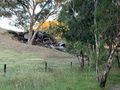
Random pile of (probably) scrap metal
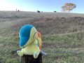
Therm at the hash

I really need to get a dedicated GPS reciever

remembered to take a picture of my watch this time

Road signs to Macclesfield, Strathalbyn, and Mt Barker


Achievements

XXOs achieved level 1 of the Minesweeper Geohash achievement
|
XXOs achieved level 1 of the Minesweeper Geohash achievement
|
Is it true that this user earned the Regional geohashing achievement?
|