Difference between revisions of "2024-02-29 -37 145"
m (→Expedition Two (BarbaraTables)) |
|||
| (12 intermediate revisions by 6 users not shown) | |||
| Line 1: | Line 1: | ||
| − | + | [[Image:{{{image|20240229_-37_145_exp3_selfie.jpeg}}}|thumb|left]] | |
| − | + | {{meetup graticule | |
| − | |||
| − | |||
| − | |||
| − | |||
| − | |||
| − | |||
| lat=-37 | | lat=-37 | ||
| lon=145 | | lon=145 | ||
| date=2024-02-29 | | date=2024-02-29 | ||
| − | }} | + | }} |
| + | |||
== Location == | == Location == | ||
On a suburban street in Murrumbeena. | On a suburban street in Murrumbeena. | ||
| + | <div style="clear: left"></div> | ||
== Participants == | == Participants == | ||
| − | + | '''Expedition One''' | |
* [[User:Felix Dance|Felix]] | * [[User:Felix Dance|Felix]] | ||
* [[User:Stevage|Stevage]] | * [[User:Stevage|Stevage]] | ||
| − | + | '''Expedition Two''' | |
* [[User:BarbaraTables|BarbaraTables]] | * [[User:BarbaraTables|BarbaraTables]] | ||
| − | + | '''Expedition Three''' | |
* [[User:Cam (2013)|Cam]] | * [[User:Cam (2013)|Cam]] | ||
* [[User:Johnwrw|John]] | * [[User:Johnwrw|John]] | ||
* [[User:Pwc|Patrick]] | * [[User:Pwc|Patrick]] | ||
| − | + | '''Expedition Four''' | |
* [[User:Wizdude|Wizdude]] | * [[User:Wizdude|Wizdude]] | ||
| − | + | '''Expedition Five''' | |
* Patrick's childhood friend | * Patrick's childhood friend | ||
| − | + | '''Expedition Six''' | |
* [[User:Lachie|Lachie]] | * [[User:Lachie|Lachie]] | ||
| − | == | + | == Expedition == |
| − | <!-- | + | === Expedition One (Felix and Stevage) === |
| + | <gallery mode="packed" heights="300px"> | ||
| + | |||
| + | Image:2024-02-29_-37_145_Felix Dance_1709202643557.jpg|At the hash! | ||
| + | |||
| + | Image:2024-02-29_-37_145_Felix Dance_1709202658139.jpg|Hash VB | ||
| + | |||
| + | Image:2024-02-29_-37_145_Felix Dance_1709202672368.jpg|GPS proof | ||
| + | |||
| + | File:Geohash 2024-02-29 -37 145 Route.gpx|Felix's 'tracklog' | ||
| + | </gallery> | ||
| − | |||
=== Expedition Two (BarbaraTables) === | === Expedition Two (BarbaraTables) === | ||
| Line 50: | Line 55: | ||
Headed to Chadstone afterwards since I was in the area; got some stationary for the upcoming uni semester and some food. | Headed to Chadstone afterwards since I was in the area; got some stationary for the upcoming uni semester and some food. | ||
| − | === Expedition Three === | + | <gallery mode="packed" heights="300px"> |
| + | Image:hash bt 2024 02 29 proof.PNG|GPS proof | ||
| + | Image:hash bt 2024 02 29 selfie.JPEG|Hash selfie! | ||
| + | </gallery> | ||
| + | |||
| + | |||
| + | === Expedition Three (Cam, John and Patrick) === | ||
The Leap Day Hash must be done. Plans were made, people were summoned, bikes were lubricated, and work commitments were... not skipped. | The Leap Day Hash must be done. Plans were made, people were summoned, bikes were lubricated, and work commitments were... not skipped. | ||
| − | We met at Federation Square. Somehow Patrick arrived first and enjoyed watching pedestrians wandering down the '''FOOTPATH CLOSED. DO NOT ENTER BIKE LANE. USE OTHER FOOTPATH''' lane, while waiting for Cam and | + | We met at Federation Square. Somehow Patrick arrived first and enjoyed watching pedestrians wandering down the '''FOOTPATH CLOSED. DO NOT ENTER BIKE LANE. USE OTHER FOOTPATH''' lane, while waiting for Cam and John to arrive. |
We proceeded suavely to the geohash, down the Gardiner’s Creek Trail before diverting along the <s>Suburban Rail Loop</s>Outer Circle Trail, crossing Dandenong Road a.k.a. the Princes Highway a.k.a. Highway 1 (Alternative) a.k.a. another impressive entry in the worst connected bicycle paths in Melbourne. Patrick was in the lead, meaning that we got lost many times, but eventually made it to the hash. | We proceeded suavely to the geohash, down the Gardiner’s Creek Trail before diverting along the <s>Suburban Rail Loop</s>Outer Circle Trail, crossing Dandenong Road a.k.a. the Princes Highway a.k.a. Highway 1 (Alternative) a.k.a. another impressive entry in the worst connected bicycle paths in Melbourne. Patrick was in the lead, meaning that we got lost many times, but eventually made it to the hash. | ||
| Line 61: | Line 72: | ||
The intense stress of avoiding being seen at the hash meant beers were needed. So we headed on to Kaiju Brewing, ensuring we narrowly missed meeting Expedition Four ;( However, beers were had. John and Cam stayed for dinner at Kaiju and returned home uneventfully (???????) while Patrick went to his parents’ place for dinner and returned uneventfully. | The intense stress of avoiding being seen at the hash meant beers were needed. So we headed on to Kaiju Brewing, ensuring we narrowly missed meeting Expedition Four ;( However, beers were had. John and Cam stayed for dinner at Kaiju and returned home uneventfully (???????) while Patrick went to his parents’ place for dinner and returned uneventfully. | ||
| + | |||
| + | <gallery mode="packed" heights="300px"> | ||
| + | Image:20240229_-37_145_exp3_proof.jpeg|GPS proof|alt=Geohash Droid app showing 0.998m distance | ||
| + | File:20240229_-37_145_exp3_selfie.jpeg|Expedition three beers|alt=Cam, John and Patrick smiling holding beers | ||
| + | </gallery> | ||
| + | |||
| + | ==== Tracklog ==== | ||
| + | {{ Tracklog | Geohash 2024-02-29 -37 145 Cam Afternoon Ride.gpx }} | ||
=== Expedition Four (Wizdude) === | === Expedition Four (Wizdude) === | ||
| Line 66: | Line 85: | ||
Arrived there at 7:04pm by car. | Arrived there at 7:04pm by car. | ||
| − | === Expedition Five === | + | <gallery mode="packed" heights="300px"> |
| + | Image:2024 leap hash wd proof.jpeg|GPS proof | ||
| + | Image:2024 leap hash wd selfie.JPEG | ||
| + | Image:2024 leap hash wd photo.JPEG | ||
| + | </gallery> | ||
| + | |||
| + | |||
| + | === Expedition Five (Patrick's friend) === | ||
Patrick's friend successfully achieved a first hash experience — on a leap day!!! — and described the experience as “I love it” and “Wonder how many people took a selfie outside these people's place hah” (wiki reports: at least 9), and will definitely become a committed geohasher. | Patrick's friend successfully achieved a first hash experience — on a leap day!!! — and described the experience as “I love it” and “Wonder how many people took a selfie outside these people's place hah” (wiki reports: at least 9), and will definitely become a committed geohasher. | ||
| Line 72: | Line 98: | ||
Photo and proof to come subject to consents etc. | Photo and proof to come subject to consents etc. | ||
| − | === Expedition Six === | + | === Expedition Six (Lachie) === |
[[User:Lachie|Lachie]] sent pictures to the chat with a bottle of cab sauv and baked ziti. Unsure if he survived, but sure he made it to the hash with minutes to spare. | [[User:Lachie|Lachie]] sent pictures to the chat with a bottle of cab sauv and baked ziti. Unsure if he survived, but sure he made it to the hash with minutes to spare. | ||
| − | + | <gallery mode="packed" heights="300px"> | |
| − | < | + | File:leap-day-lachie1.jpg |
| − | + | File:leap-day-lachie2.jpg | |
| − | + | File:leap-day-lachie3.jpg | |
| − | |||
| − | |||
| − | |||
| − | = | ||
| − | |||
| − | |||
| − | |||
| − | |||
| − | |||
| − | |||
| − | |||
| − | |||
| − | |||
| − | |||
| − | |||
| − | |||
| − | |||
| − | |||
| − | |||
| − | |||
| − | |||
| − | |||
| − | |||
</gallery> | </gallery> | ||
| − | |||
| − | |||
| − | |||
| − | |||
| − | |||
| − | |||
== Achievements == | == Achievements == | ||
{{#vardefine:ribbonwidth|100%}} | {{#vardefine:ribbonwidth|100%}} | ||
| + | {{bicycle geohash | ||
| + | |||
| + | | latitude = -37 | ||
| + | | longitude = 145 | ||
| + | | date = 2024-02-29 | ||
| + | | name = [[User:Felix Dance|Felix]], [[User:Stevage|Stevage]]; [[User:Cam (2013)|Cam]], [[User:Johnwrw|John]], [[User:Pwc|Patrick]] | ||
| + | | distance = 55 kms | ||
| + | | bothways = true (optional) | ||
| + | | image = 2024-02-29_-37_145_Felix Dance_1709202643557.jpg | ||
| + | }} | ||
{{land geohash | {{land geohash | ||
| Line 118: | Line 125: | ||
| longitude = 145 | | longitude = 145 | ||
| date = 2024-02-29 | | date = 2024-02-29 | ||
| − | | name = [[User:BarbaraTables|BarbaraTables]] | + | | name = [[User:Felix Dance|Felix]], [[User:Stevage|Stevage]], [[User:BarbaraTables|BarbaraTables]], [[User:Cam (2013)|Cam]], [[User:Johnwrw|John]], [[User:Pwc|Patrick]], [[User:Wizdude|Wizdude]], Patrick's friend, and [[User:Lachie|Lachie]] |
}} | }} | ||
| Line 126: | Line 133: | ||
| lat = -37 | | lat = -37 | ||
| lon = 145 | | lon = 145 | ||
| − | | name = | + | | name = [[User:Felix Dance|Felix]], [[User:Stevage|Stevage]], [[User:BarbaraTables|BarbaraTables]], [[User:Cam (2013)|Cam]], [[User:Johnwrw|John]], [[User:Pwc|Patrick]], [[User:Wizdude|Wizdude]], Patrick's friend, and [[User:Lachie|Lachie]] |
| + | |||
| + | }} | ||
| + | {{Minesweeper geohash | ||
| + | |||
| + | | graticule = Melbourne East, Australia | ||
| + | | ranknumber = 1 | ||
| + | | w = true | ||
| + | | name = [[User:Wizdude|Wizdude]] | ||
}} | }} | ||
| − | {{ | + | |
| + | {{inarow | ||
| latitude = -37 | | latitude = -37 | ||
| longitude = 145 | | longitude = 145 | ||
| date = 2024-02-29 | | date = 2024-02-29 | ||
| − | | name = [[User: | + | | level = 2 |
| + | | graticule1 = [[2024-02-02_-37_144|-37, 144]] | ||
| + | | graticule2 = [[2024-02-29_-37_145|-37, 145]] | ||
| + | | name = [[User:Wizdude|Wizdude]] | ||
}} | }} | ||
| + | {{Public transport geohash | ||
| − | + | | latitude = -37 | |
| − | + | | longitude = 145 | |
| − | + | | date = 2024-02-29 | |
| − | [[ | + | | name = [[User:BarbaraTables|BarbaraTables]] |
| − | + | }} | |
| + | {{Two to the N achievement | ||
| − | + | | count = 0 | |
| − | + | | date = 2024-02-29 | |
| − | + | | latitude = -37 | |
| − | + | | longitude = 145 | |
| + | | name = Patrick's friend | ||
| + | | reached = true | ||
| − | + | }} | |
| + | {{Two to the N achievement | ||
| − | + | | count = 1 | |
| − | + | | date = 2024-02-29 | |
| − | + | | latitude = -37 | |
| − | + | | longitude = 145 | |
| − | + | | name = [[User:Wizdude|Wizdude]] | |
| − | [[ | + | | reached = true |
| − | |||
| − | |||
| − | |||
| − | |||
| + | }} | ||
| − | + | __NOTOC__ | |
| − | |||
| − | |||
| − | |||
| − | |||
| − | |||
| − | |||
| − | |||
| − | |||
| − | |||
| − | |||
| − | |||
| − | |||
| − | |||
| − | |||
| − | |||
[[Category:Expeditions]] | [[Category:Expeditions]] | ||
[[Category:Expeditions with photos]] | [[Category:Expeditions with photos]] | ||
[[Category:Coordinates reached]] | [[Category:Coordinates reached]] | ||
| + | {{location|AU|VIC|GE}} | ||
Latest revision as of 13:02, 19 April 2024

| Thu 29 Feb 2024 in -37,145: -37.9025002, 145.0667534 geohashing.info google osm bing/os kml crox |
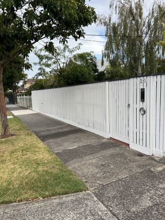
Location
On a suburban street in Murrumbeena.
Participants
Expedition One
Expedition Two
Expedition Three
Expedition Four
Expedition Five
- Patrick's childhood friend
Expedition Six
Expedition
Expedition One (Felix and Stevage)
At the hash!
Hash VB
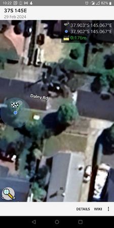
GPS proof
Felix's 'tracklog'


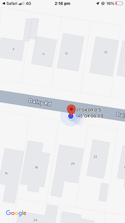
Expedition Two (BarbaraTables)
Leap Day Hash!
For all the other Wiki editors trying to work out the correct order to put these expeditions in, I got there at 2:16pm. I said I was going to get there at 12:00pm, but my sleepiness said no.
I got there, as usual, by public transport. As soon as I got off the last bus, I Pythagorased to the coffee like the Melburbian I am, then went to the Hash.
I actually saw the homeowner of the adjacent house when I got there; they were exiting the driveway in their car, waiting for an opening in the traffic. I waited for their car to move off the path as if I were walking past, and we exchanged polite gestures as they left (in response to my patience).
Kinda decided to keep walking on until they had driven off to avoid looking insane and/or suspicious, then just took a selfie nearby. I wanted to do a pano of the street, but I kept getting interrupted by cars driving by and didn't want to look like I was trying to video them (or have a messed up pano).
Headed to Chadstone afterwards since I was in the area; got some stationary for the upcoming uni semester and some food.
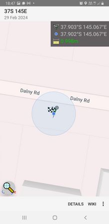
GPS proof

Hash selfie!


Expedition Three (Cam, John and Patrick)
The Leap Day Hash must be done. Plans were made, people were summoned, bikes were lubricated, and work commitments were... not skipped.
We met at Federation Square. Somehow Patrick arrived first and enjoyed watching pedestrians wandering down the FOOTPATH CLOSED. DO NOT ENTER BIKE LANE. USE OTHER FOOTPATH lane, while waiting for Cam and John to arrive.
We proceeded suavely to the geohash, down the Gardiner’s Creek Trail before diverting along the Suburban Rail LoopOuter Circle Trail, crossing Dandenong Road a.k.a. the Princes Highway a.k.a. Highway 1 (Alternative) a.k.a. another impressive entry in the worst connected bicycle paths in Melbourne. Patrick was in the lead, meaning that we got lost many times, but eventually made it to the hash.
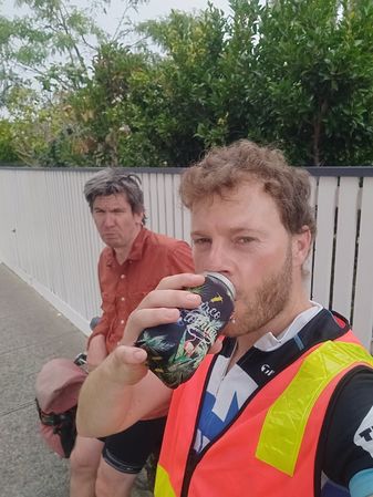
Upon hash arrival, we bumbled around to get a good distance measure, and had traditional at-hash beers. As we were doing this, the resident of the property directly adjacent to the hash returned so we awkwardly wandered away trying to ensure our faces were not visible.
The intense stress of avoiding being seen at the hash meant beers were needed. So we headed on to Kaiju Brewing, ensuring we narrowly missed meeting Expedition Four ;( However, beers were had. John and Cam stayed for dinner at Kaiju and returned home uneventfully (???????) while Patrick went to his parents’ place for dinner and returned uneventfully.
GPS proof
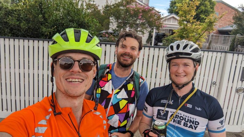
Expedition three beers

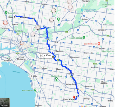
Tracklog
Expedition Four (Wizdude)
Arrived there at 7:04pm by car.

GPS proof


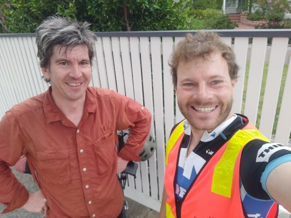
Expedition Five (Patrick's friend)
Patrick's friend successfully achieved a first hash experience — on a leap day!!! — and described the experience as “I love it” and “Wonder how many people took a selfie outside these people's place hah” (wiki reports: at least 9), and will definitely become a committed geohasher.
Photo and proof to come subject to consents etc.
Expedition Six (Lachie)
Lachie sent pictures to the chat with a bottle of cab sauv and baked ziti. Unsure if he survived, but sure he made it to the hash with minutes to spare.


Achievements
Felix, Stevage; Cam, John, Patrick earned the Bicycle geohash achievement
|
Felix, Stevage, BarbaraTables, Cam, John, Patrick, Wizdude, Patrick's friend, and Lachie earned the Land geohash achievement
|

Wizdude achieved level 1 of the Minesweeper Geohash achievement
|
Wizdude earned the 2-in-a-row achievement
|
BarbaraTables earned the Public transport geohash achievement
|

- Meetup on 2024-02-29
- Meetup in -37 145
- Expeditions with tracklogs
- Bicycle geohash achievement
- Land geohash achievement
- Leap geohash achievement
- Minesweeper geohash achievement
- N-in-a-row achievement
- Public transport geohash achievement
- Two to the N achievement
- Expeditions
- Expeditions with photos
- Coordinates reached
- Meetup in the City of Glen Eira