Difference between revisions of "2024-03-06 26 -98"
From Geohashing
Lightrider (talk | contribs) (An expedition message sent via Geohash Droid for Android.) |
m (Location) |
||
| (11 intermediate revisions by 2 users not shown) | |||
| Line 1: | Line 1: | ||
| − | + | {{meetup graticule | |
| − | |||
| − | |||
| − | |||
| − | |||
| − | |||
| − | |||
| − | |||
| − | |||
| lat=26 | | lat=26 | ||
| lon=-98 | | lon=-98 | ||
| date=2024-03-06 | | date=2024-03-06 | ||
| − | }} | + | }} |
== Location == | == Location == | ||
| − | + | Just off of a frontage road, behind a fence on private property. | |
== Participants == | == Participants == | ||
| − | + | *[[User:Lightrider|Lightrider]] | |
| − | |||
== Plans == | == Plans == | ||
| − | + | *I expect to visit this one today! -- [[User:Lightrider|Lightrider]] ([[User talk:Lightrider|talk]]) 13:18, 6 March 2024 (CST) | |
== Expedition == | == Expedition == | ||
| − | + | I was already going to be going down this highway due to seeing a friend's academic presentation at a nearby college. It turned out to be a great day! -[[User:Lightrider|Lightrider]] ([[User talk:Lightrider|talk]]) | |
| − | |||
| − | |||
| − | |||
== Photos == | == Photos == | ||
| − | |||
| − | |||
| − | |||
<gallery perrow="5"> | <gallery perrow="5"> | ||
| + | |||
| + | Image:2024-03-06_26_-98_Lightrider_1709766547076.jpg|Success! [https://openstreetmap.org/?mlat=26.23916667&mlon=-98.17611111&zoom=16 @26.2392,-98.1761] | ||
| + | |||
| + | Image:2024-03-06_26_-98_Lightrider_1709766595647.jpg|Fenced off point. It's right next to the tree. [https://openstreetmap.org/?mlat=26.23916667&mlon=-98.17611111&zoom=16 @26.2392,-98.1761] | ||
</gallery> | </gallery> | ||
| Line 38: | Line 27: | ||
{{#vardefine:ribbonwidth|100%}} | {{#vardefine:ribbonwidth|100%}} | ||
<!-- Add any achievement ribbons you earned below, or remove this section --> | <!-- Add any achievement ribbons you earned below, or remove this section --> | ||
| + | {{No trespassing |latitude=26 |longitude=-98 |date=2024-03-06 |image=2024-03-06_26_-98_Lightrider_1709766595647.jpg |name= [[User:Lightrider|Lightrider]] ([[User talk:Lightrider|talk]]) |distance=35m }} | ||
__NOTOC__ | __NOTOC__ | ||
| − | |||
| − | |||
| − | |||
| − | |||
| − | |||
| − | |||
| − | |||
| − | |||
| − | |||
| − | |||
| − | |||
| − | |||
| − | |||
| − | |||
[[Category:Expeditions]] | [[Category:Expeditions]] | ||
| − | |||
[[Category:Expeditions with photos]] | [[Category:Expeditions with photos]] | ||
| − | |||
| − | |||
| − | |||
| − | |||
| − | |||
| − | |||
| − | |||
| − | |||
| − | |||
[[Category:Coordinates not reached]] | [[Category:Coordinates not reached]] | ||
| − | |||
| − | |||
| − | |||
| − | |||
| − | |||
[[Category:Not reached - No public access]] | [[Category:Not reached - No public access]] | ||
| − | + | {{location|US|TX|HG}} | |
| − | |||
| − | |||
| − | |||
| − | |||
| − | |||
| − | |||
| − | |||
Latest revision as of 15:43, 16 March 2024
| Wed 6 Mar 2024 in 26,-98: 26.2389110, -98.1759024 geohashing.info google osm bing/os kml crox |
Location
Just off of a frontage road, behind a fence on private property.
Participants
Plans
- I expect to visit this one today! -- Lightrider (talk) 13:18, 6 March 2024 (CST)
Expedition
I was already going to be going down this highway due to seeing a friend's academic presentation at a nearby college. It turned out to be a great day! -Lightrider (talk)
Photos
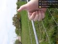
Success! @26.2392,-98.1761
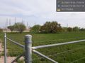
Fenced off point. It's right next to the tree. @26.2392,-98.1761


Achievements
Lightrider (talk) earned the No trespassing consolation prize
|