Difference between revisions of "2024-03-10 -37 144"
([retro picture]Nice sky) |
(→Correct day expedition) |
||
| (3 intermediate revisions by 2 users not shown) | |||
| Line 1: | Line 1: | ||
| − | + | {{meetup graticule | |
| − | |||
| − | |||
| − | |||
| − | |||
| − | |||
| − | |||
| − | |||
| − | |||
| lat=-37 | | lat=-37 | ||
| lon=144 | | lon=144 | ||
| date=2024-03-10 | | date=2024-03-10 | ||
| − | }} | + | }} |
== Location == | == Location == | ||
| − | + | In an empty lot next to a car repair centre in Albion | |
== Participants == | == Participants == | ||
| − | + | [[User:Johnwrw|John]] | |
| − | |||
== Plans == | == Plans == | ||
| − | + | On Saturday morning, I discovered that Sunday's hash was only 6.74km from my house and accessible in a very straight line. I was very interested! From the streetview images it appeared to be behind a fence, but there were indications that the fence might have holes in it. | |
== Expedition == | == Expedition == | ||
| − | + | ===Pre-retrohash=== | |
| + | I was planning to go for a longish run on Sunday morning anyway, so I decided to go suss out the hash a day early. I went west in a very straight line, with a slight wobble to use the pedestrian underpass at Albion station. I got to the fence and as I had hoped, there were large holes in it. I went in to the hash point and discovered that there was no fencing between part of the car yard and this part so it probably was their property. But they were shut on weekends, so there was no-one around to kick up any sort of fuss. There was a sign claiming surveillance of the property, but I didn't worry too much about this. If it even existed and covered where I was, I doubt it was closely monitored. If they were serious about security they would have patched up the gaping holes in the fence. | ||
| − | == | + | I continued on my run, going past a mosque where I found interesting the signs on the outer fence, (not by the door), about sock wearing expectations. I got up to the path along the ring road, I followed this up over the EJ Whitten bridge crossing the Maribyrnong, whereupon I headed down to water level to follow the river back home. It was getting quite hot by the time I got home. |
| − | + | ||
| + | I contemplated heading back to the hash for the midnight hash achievement that very night, but I was too tired in the end. It would have to wait for the next day. | ||
| + | |||
| + | <gallery heights="300px" mode="packed"> | ||
| + | Image:2024-03-10_-37_144_Johnwrw_1710118552015.jpg|Pre retro success | ||
| + | |||
| + | Image:2024-03-10_-37_144_Johnwrw_1710118570992.jpg|Mosque | ||
| + | |||
| + | </gallery> | ||
| + | |||
| + | ===Correct day expedition=== | ||
| + | I had to wait a while to get back to the hash. The day was taken up with a trip to Mansfield to visit Bridget's grandmother. It was another scorcher anyway, so I wouldn't have wanted to venture out in the heat of the day in any case. Most of the appeal of joining Bridget's visit to Mansfield was the access to air-conditioning that I would not have had at home. | ||
| + | |||
| + | Around 6pm we got back home, and after a spot of dinner I decided that now was the time to venture out again, this time by bike. As mentioned I could get to the hash in a very straight line so the Juggernaut achievement was obvious to go for. I had to go on the footpath for one section of Mitchell St that I find intriguing - it is a two-lane one-way street. I obvious had to go the [https://www.youtube.com/watch?v=LW7Iv-V1-Jo the wrong way]. | ||
| + | |||
| + | Being on a bicycle as opposed to on foot did help me maintain a straighter line. I could use the road bridge over the train line at Albion instead of wobbling to use the underpass. An even straighter line could possibly have been achieved through some tough bush bashing to get to the train line on the north side of the bridge, followed by illegally crossing the line at ground level. But I have reduced appetite for railway-trespassing at present. | ||
| + | |||
| + | After the bridge, I went to the north side of the road to be closer to the straight line, but there was no path here. I was riding on grass. I soon got to the right spot. It was looking as deserted and accessible as yesterday. But this time the sky was looking lovely, with multiple layers of clouds atop the colours of sunset. I went through the hole in the fence, and walked straight to where I knew the point to be. | ||
| + | |||
| + | Because I had visited just the day before I had reached the point without the aid of any navigational equipment at all. By memory I went to the point, and only then opened up the geohashing app. After a few seconds I satisfyingly saw the read-out resolve to less than a metre without needing to adjust my position any further. As a result, even though I confirmed my location via GPS, I think I can award myself the no batteries achievement for actually getting there without its help. | ||
| + | |||
| + | I drank a quick hydrating celebratory non-alcoholic beer that I got from cheaper buy miles (annoyingly prices have gone up from $4 to $5 for a 4-pack, but that is still extremely reasonable), and then went back home. With the juggernauting part done, I could take a nicer route home than Ballarat Rd. | ||
| + | |||
| + | I got home, and that evening we watched Dune part one, so that we could go and watch part two the next day in the cinema, again to make use of their air-conditioning. | ||
| + | |||
| + | <gallery heights="300px" mode="packed"> | ||
| − | |||
| − | |||
| − | |||
| − | |||
| − | |||
Image:2024-03-10_-37_144_Johnwrw_1710062486269.jpg|Success | Image:2024-03-10_-37_144_Johnwrw_1710062486269.jpg|Success | ||
| Line 38: | Line 50: | ||
Image:2024-03-10_-37_144_Johnwrw_1710062508959.jpg|GPS proof | Image:2024-03-10_-37_144_Johnwrw_1710062508959.jpg|GPS proof | ||
| − | Image:2024-03-10_- | + | Image:2024-03-10_-37_144_Johnwrw_1710118594723.jpg|Scenery |
| − | Image:2024-03-10_- | + | Image:2024-03-10_-37_144_Johnwrw_1710118605953.jpg|Nice sky |
| − | Image:2024-03-10_- | + | Image:2024-03-10_-37_144_Johnwrw_1710118622693.jpg|Ballarat rd |
| − | |||
</gallery> | </gallery> | ||
| + | |||
| + | == Tracklog == | ||
| + | After the fact analysis says that I deviated just 70.1m from the straight line over 6.74km, which is just over 1%. I believe this is the second straightest line achieved to a geohash after [[2019-02-28_-70_-8|this incredible expedition]] | ||
| + | |||
| + | {{tracklog | -37_144_2024-03-10_Tracklog.gpx}} | ||
== Achievements == | == Achievements == | ||
{{#vardefine:ribbonwidth|100%}} | {{#vardefine:ribbonwidth|100%}} | ||
| − | + | {{Juggernaut achievement | latitude = -37 | longitude = 144 | date = 2024-03-10 | deviation = 96 | name = John }} | |
| + | {{No_batteries_geohash | latitude = -37 | longitude = 144 | date = 2024-03-10 | name = John }} | ||
__NOTOC__ | __NOTOC__ | ||
| − | |||
| − | |||
| − | |||
| − | |||
| − | |||
| − | |||
| − | |||
| − | |||
| − | + | [[Category:Expeditions]] | |
| − | |||
| − | |||
| − | |||
[[Category:Expeditions with photos]] | [[Category:Expeditions with photos]] | ||
| − | |||
| − | |||
| − | |||
| − | + | ||
[[Category:Coordinates reached]] | [[Category:Coordinates reached]] | ||
| − | + | [[Category:Retro meetup]] | |
| − | + | [[Category:Retro coordinates reached]] | |
| − | + | {{location|AU|VIC|BR}} | |
| − | |||
| − | |||
| − | |||
| − | |||
| − | |||
| − | [[Category: | ||
| − | |||
| − | |||
| − | [[Category: | ||
| − | |||
| − | |||
| − | |||
| − | |||
| − | |||
Latest revision as of 11:35, 12 March 2024
| Sun 10 Mar 2024 in -37,144: -37.7746552, 144.8130583 geohashing.info google osm bing/os kml crox |
Location
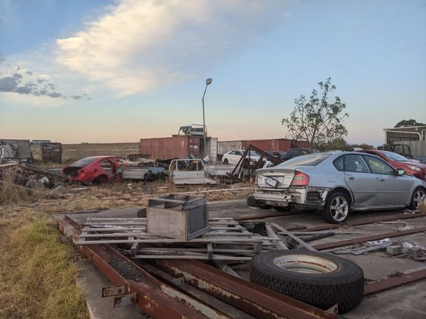
In an empty lot next to a car repair centre in Albion
Participants
Plans
On Saturday morning, I discovered that Sunday's hash was only 6.74km from my house and accessible in a very straight line. I was very interested! From the streetview images it appeared to be behind a fence, but there were indications that the fence might have holes in it.
Expedition
Pre-retrohash
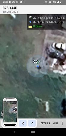
I was planning to go for a longish run on Sunday morning anyway, so I decided to go suss out the hash a day early. I went west in a very straight line, with a slight wobble to use the pedestrian underpass at Albion station. I got to the fence and as I had hoped, there were large holes in it. I went in to the hash point and discovered that there was no fencing between part of the car yard and this part so it probably was their property. But they were shut on weekends, so there was no-one around to kick up any sort of fuss. There was a sign claiming surveillance of the property, but I didn't worry too much about this. If it even existed and covered where I was, I doubt it was closely monitored. If they were serious about security they would have patched up the gaping holes in the fence.
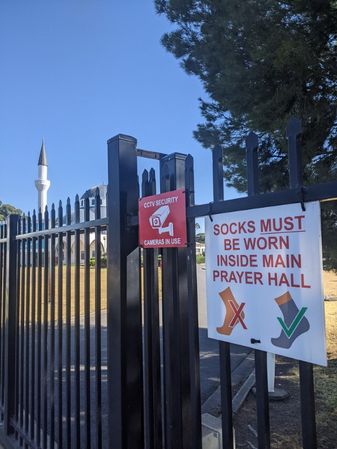
I continued on my run, going past a mosque where I found interesting the signs on the outer fence, (not by the door), about sock wearing expectations. I got up to the path along the ring road, I followed this up over the EJ Whitten bridge crossing the Maribyrnong, whereupon I headed down to water level to follow the river back home. It was getting quite hot by the time I got home.
I contemplated heading back to the hash for the midnight hash achievement that very night, but I was too tired in the end. It would have to wait for the next day.
Pre retro success
Mosque


Correct day expedition
I had to wait a while to get back to the hash. The day was taken up with a trip to Mansfield to visit Bridget's grandmother. It was another scorcher anyway, so I wouldn't have wanted to venture out in the heat of the day in any case. Most of the appeal of joining Bridget's visit to Mansfield was the access to air-conditioning that I would not have had at home.
Around 6pm we got back home, and after a spot of dinner I decided that now was the time to venture out again, this time by bike. As mentioned I could get to the hash in a very straight line so the Juggernaut achievement was obvious to go for. I had to go on the footpath for one section of Mitchell St that I find intriguing - it is a two-lane one-way street. I obvious had to go the the wrong way.
Being on a bicycle as opposed to on foot did help me maintain a straighter line. I could use the road bridge over the train line at Albion instead of wobbling to use the underpass. An even straighter line could possibly have been achieved through some tough bush bashing to get to the train line on the north side of the bridge, followed by illegally crossing the line at ground level. But I have reduced appetite for railway-trespassing at present.
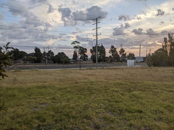
After the bridge, I went to the north side of the road to be closer to the straight line, but there was no path here. I was riding on grass. I soon got to the right spot. It was looking as deserted and accessible as yesterday. But this time the sky was looking lovely, with multiple layers of clouds atop the colours of sunset. I went through the hole in the fence, and walked straight to where I knew the point to be.
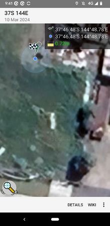
Because I had visited just the day before I had reached the point without the aid of any navigational equipment at all. By memory I went to the point, and only then opened up the geohashing app. After a few seconds I satisfyingly saw the read-out resolve to less than a metre without needing to adjust my position any further. As a result, even though I confirmed my location via GPS, I think I can award myself the no batteries achievement for actually getting there without its help.
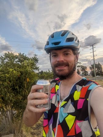
I drank a quick hydrating celebratory non-alcoholic beer that I got from cheaper buy miles (annoyingly prices have gone up from $4 to $5 for a 4-pack, but that is still extremely reasonable), and then went back home. With the juggernauting part done, I could take a nicer route home than Ballarat Rd.
I got home, and that evening we watched Dune part one, so that we could go and watch part two the next day in the cinema, again to make use of their air-conditioning.
Success
GPS proof
Scenery

Nice sky
Ballarat rd


Tracklog
After the fact analysis says that I deviated just 70.1m from the straight line over 6.74km, which is just over 1%. I believe this is the second straightest line achieved to a geohash after this incredible expedition
Achievements
John earned the Juggernaut achievement
|
John earned the No Batteries Geohash Achievement
|