Difference between revisions of "2024-03-10 49 8"
Green guy! (talk | contribs) (More info about the wall seen on Bing Aerial) |
Green guy! (talk | contribs) (Add gallery with captions) |
||
| Line 31: | Line 31: | ||
After lunch, we visited the hashpoint: We stopped our car in front of a private driveway for a few minutes (there was no room for parking nearby) so I could hop out and quickly visit the hashpoint. A woman came our way, making sure that we didn’t block the driveway with bad intentions. I took the opportunity to guide her to the hashpoint, where I briefly explained geohashing and the [[Algorithm]], but she didn’t really comprehend what I was talking about. Unfortunately, this didn’t earn me any achievements as she was a stranger who isn’t a geohasher; also, she didn’t agree to let her name or photos of her published. | After lunch, we visited the hashpoint: We stopped our car in front of a private driveway for a few minutes (there was no room for parking nearby) so I could hop out and quickly visit the hashpoint. A woman came our way, making sure that we didn’t block the driveway with bad intentions. I took the opportunity to guide her to the hashpoint, where I briefly explained geohashing and the [[Algorithm]], but she didn’t really comprehend what I was talking about. Unfortunately, this didn’t earn me any achievements as she was a stranger who isn’t a geohasher; also, she didn’t agree to let her name or photos of her published. | ||
| − | After that, we parked our car next to the ''Odenwaldidyll'' camping site to then visit the nearby castle ''Schloss Lichtenberg'' by foot: It was interesting, but also really exhausting due to the 90 meters of height gain from parking lot to castle and because we aren’t used to these conditions (as we live in the Rhein-Main valley/flatland); also, we could have driven up the castle by car, saving us some of that effort, but I thought it was closer (and easier to reach?) from the camping site. All of us, especially me, were extremely tired after finishing the trip. | + | After that, we parked our car next to the ''Odenwaldidyll'' camping site to then visit the nearby castle ''Schloss Lichtenberg'' and its ''Bollwerk'' (bulwark) by foot: It was interesting, but also really exhausting due to the 90 meters of height gain from parking lot to castle and because we aren’t used to these conditions (as we live in the Rhein-Main valley/flatland); also, we could have driven up the castle by car, saving us some of that effort, but I thought it was closer (and easier to reach?) from the camping site. All of us, especially me, were extremely tired after finishing the trip. |
== Tracklog: Visiting ''Schloss Lichtenberg'' == | == Tracklog: Visiting ''Schloss Lichtenberg'' == | ||
| Line 39: | Line 39: | ||
== Pictures == | == Pictures == | ||
| − | <! | + | === At ''Restaurant DHILLON'' === |
| − | + | <gallery> | |
| − | + | File:Green guy! 20240310_125419 funny parking forbidden sign EDITED.jpg | A really funny “parking forbidden” sign I encountered next to the restaurant <small>(check out the transcription on the image’s page)</small> | |
| − | + | File:Green guy! 20240310_133345 Chicken Korma at Restaurant DHILLION.jpg | Chicken Korma at the restaurant, served in separate containers for self-service | |
| − | + | </gallery> | |
| − | <!- | + | === Reaching the hashpoint === |
| + | <gallery> | ||
| + | File:Green guy! 20240310_141803 Hashpoint from car.jpg | Looking south-southwest from our car: hashpoint straight ahead! | ||
| + | File:Green guy! 20240310_141846_OruxMaps Coordinates.png | Coordinates reached | ||
| + | File:Green guy! 20240310_141852 Hashpoint.jpg | The hashpoint: a retaining wall | ||
| + | File:Green guy! 20240310_141911 Hashpoint grin 1.jpg | Funny grin | ||
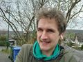
| + | File:Green guy! 20240310_141928 Hashpoint grin 2.jpg | ||
| + | </gallery> | ||
| + | === Visiting ''Schloss Lichtenberg'' === | ||
<gallery> | <gallery> | ||
| + | File:Green guy! 20240310_144550 Shrubtree.jpg | <dfn>Shrubtree</dfn>: a tree with a trimmed shrub at its base | ||
| + | File:Green guy! 20240310_144752 Gap in the castle wall.jpg | Entering the castle through a hole in the wall | ||
| + | File:Green guy! 20240310_144907 Castle courtyard.jpg | Castle courtyard | ||
| + | File:Green guy! 20240310_145830 Frog perspective.jpg | Frog perspective of a staircase leading to a door | ||
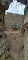
| + | File:Green guy! 20240310_150300 Castle entrance tunnel.jpg | The castle’s entrance passage, looking in inward direction | ||
| + | File:Green guy! 20240310_151524 View.jpg | Beautiful scenery viewed from the ''Bollwerk'' | ||
</gallery> | </gallery> | ||
| Line 89: | Line 103: | ||
<!-- ==REQUEST FOR TWITTER BOT== Please leave either the New report or the Expedition planning category in as long as you work on it. This helps the twitter bot a lot with announcing the right outcome at the right moment. --> | <!-- ==REQUEST FOR TWITTER BOT== Please leave either the New report or the Expedition planning category in as long as you work on it. This helps the twitter bot a lot with announcing the right outcome at the right moment. --> | ||
| − | + | [[Category:Expeditions]] | |
| − | + | [[Category:Expeditions with photos]] | |
| − | |||
| − | |||
[[Category:Coordinates reached]] | [[Category:Coordinates reached]] | ||
Revision as of 16:09, 12 March 2024
Fun Fact
This date is also known as 2024’s Super Mario (MAR10) Day, so I’m going to also refer to this page as 2024-MAR10 49 8.
| Sun 10 Mar 2024 in 49,8: 49.7746552, 8.8130583 geohashing.info google osm bing/os kml crox |
Location
Next to the road Am Schloßberg in the settlement of Niedernhausen, Fischbachtal, Hesse, Germany. According to Bing Aerial, there’s some kind of wall next to the hashpoint. (The wall turned out to not be a regular two-sided wall, but instead a one-sided retaining wall, with the hashpoint on the higher, north side of the wall.)
Participants
- Green guy! (talk)
- Green guy!’s mother (no consent to publish photos of her)
- Green guy!’s father (no consent to publish photos of him)
Plans
- Drive to Fischbachtal after being done with this Sunday’s church service at CGD
- Have lunch at Restaurant DHILLION
- Visit the hashpoint
- Go on a walk to visit the nearby castle Schloss Lichtenberg
- Drive back home
Expedition
As planned, after Sunday church service, my parents and I drove to Restaurant DHILLION in Niedernhausen, Fischbachtal. We had a delightful time there; I ate a delicious Chicken Korma with rice.
After lunch, we visited the hashpoint: We stopped our car in front of a private driveway for a few minutes (there was no room for parking nearby) so I could hop out and quickly visit the hashpoint. A woman came our way, making sure that we didn’t block the driveway with bad intentions. I took the opportunity to guide her to the hashpoint, where I briefly explained geohashing and the Algorithm, but she didn’t really comprehend what I was talking about. Unfortunately, this didn’t earn me any achievements as she was a stranger who isn’t a geohasher; also, she didn’t agree to let her name or photos of her published.
After that, we parked our car next to the Odenwaldidyll camping site to then visit the nearby castle Schloss Lichtenberg and its Bollwerk (bulwark) by foot: It was interesting, but also really exhausting due to the 90 meters of height gain from parking lot to castle and because we aren’t used to these conditions (as we live in the Rhein-Main valley/flatland); also, we could have driven up the castle by car, saving us some of that effort, but I thought it was closer (and easier to reach?) from the camping site. All of us, especially me, were extremely tired after finishing the trip.
Tracklog: Visiting Schloss Lichtenberg
Pictures
At Restaurant DHILLON
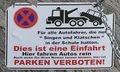
A really funny “parking forbidden” sign I encountered next to the restaurant (check out the transcription on the image’s page)
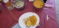
Chicken Korma at the restaurant, served in separate containers for self-service


Reaching the hashpoint
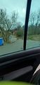
Looking south-southwest from our car: hashpoint straight ahead!
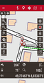
Coordinates reached
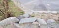
The hashpoint: a retaining wall
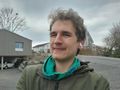
Funny grin


Visiting Schloss Lichtenberg
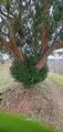
Shrubtree: a tree with a trimmed shrub at its base
Entering the castle through a hole in the wall
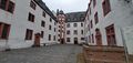
Castle courtyard
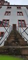
Frog perspective of a staircase leading to a door
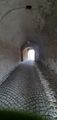
The castle’s entrance passage, looking in inward direction
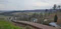
Beautiful scenery viewed from the Bollwerk


Achievements
First-time
I earned these for the first time from this geohash.

Recurring
I already earned these from an earlier geohash, but fulfilled the conditions again on this one.
Green guy! (talk) earned the Land geohash achievement
|
Unfortunately, I neither got permission to take a photo with the foreign woman I met at the hashpoint, nor to mention her name here. Also, the person is not a geohasher. These circumstances deny me from getting the Meet-up achievement on this expedition, and the Drag-along achievement doesn’t fit either.