Difference between revisions of "2024-03-12 32 34"
([live] Dolfin Junction. Map thinks I'm in Beirut. This might be tricky.) |
Yerushalmi (talk | contribs) |
||
| Line 13: | Line 13: | ||
}}<!-- edit as necessary --> | }}<!-- edit as necessary --> | ||
== Location == | == Location == | ||
| − | + | In an abandoned building at the west end of the grounds of the old Haifa Central Bus Station. | |
| + | |||
| + | Based on [[User:Yerushalmi|Yerushalmi]] ([[User talk:Yerushalmi|talk]])'s research, the building is *probably* the garage at which buses were serviced. The building was abandoned in 2013 and purchased by the Nitsba Group in 2018. As of January 2019 (the latest Street View) it was still unused and surrounded on all sides by either train tracks or fences. From some angles I can see the building has broken windows and graffiti. | ||
| + | |||
| + | Satellite photographs on both Bing and Google, which are undated but will be more recent than 2019, show no vehicles, construction, or other activity anywhere in the complex - neither the main bus station to the east nor any of the smaller buildings. | ||
| + | |||
| + | Haifa GIS labels the building as having the addresses Hahagana 22 and Hahagana 24. There are a couple of companies listed as having those addresses, which gave me hope - but the pictures uploaded by those companies make it clear they're elsewhere on the street, confirmed by Google Maps. Even Hahagana 20 and 18 are found elsewhere. I haven't checked lower numbers than this. | ||
| + | |||
| + | It's virtually certain that all of the buildings that belonged to the station, including this one, remain completely undeveloped and unused. And probably inaccessible to boot. | ||
== Participants == | == Participants == | ||
| − | + | [[User:Yerushalmi|Yerushalmi]] ([[User talk:Yerushalmi|talk]]) | |
| − | + | ||
| + | [[User:MetricSystemDude|MetricSystemDude]] | ||
== Plans == | == Plans == | ||
| − | + | === Yerushalmi === | |
| + | I'd been sick since Saturday morning, though getting better. If I'm feeling okay in the morning, I'll go with my wife to Tel Aviv to drop off her artwork at a gallery, then continue to Haifa to the point, coordinating with [[User:MetricSystemDude|MetricSystemDude]] and/or [[User:January_First-of-May|January First-of-May]] to meet them there if possible. If my return home is early enough and lucky enough, I might even try to reach 31 34, making this my first two-hash day. | ||
== Expedition == | == Expedition == | ||
| − | + | === Yerushalmi === | |
| + | I woke up in the morning feeling perfectly fine. I took my temperature - a very, very slight fever of 36.4 degrees. Only an hour later, however, it dropped to my normal body temperature of 35.9. A-hashing I will go! | ||
| + | |||
| + | My wife and I got on the 09:59 train to Modi'in, and from there another train to Tel Aviv (we didn't take the direct route so as to avoid crowds, because I was carrying a large plaster cat and she a large painting). | ||
| + | |||
| + | We took the #4, famously the worst bus in Tel Aviv, to the gallery, dropped off the paintings, and walked back to the train station. Here we parted: me to Haifa, she home to Jerusalem. | ||
| + | |||
| + | Arriving in Haifa, I decided before leaving the train station to see if I could see the building from the platform. It looked as abandoned as in the satellite photos. On the one hand, active construction would probably make it impossible to enter; on the other hand, if it's still abandoned, there are probably fences. | ||
| + | |||
| + | But I didn't come this far to give up. I left the train station, turned right, turned right again, and as I approached the central bus station that looked as abandoned as ever my jaw dropped: to my right, the main roads in and out of the bus station had been turned into a parking lot! | ||
| + | |||
| + | Not "officially", as in there weren't guards or costs or anything like that. It was just open, and dozens of cars were parked along both sides of the road. I could just walk in. This is great! | ||
| + | |||
| + | As I walked down the street, I heard the barking of dogs to my left, inside the abandoned bus station. This will not turn out to be important ''at all''. | ||
| + | |||
| + | At the end of the parking lot, a quick right (the road is still paved) and then a left (the road is still paved) and I'm right there, in front of the building that contains the geohash. As I suspected, it's a massive and old and disused garage for repairing and maintenance of the buses that used to serve this bus station. | ||
| + | |||
| + | I was about to enter when [[User:MetricSystemDude|MetricSystemDude]] called, so instead of trying for the point just yet I gave him directions on how to reach where I was. When he could see me in the distance, I hung up and went inside. | ||
| + | |||
| + | Ah, but we're in Haifa, and thanks to the war the GPS jamming is pretty much non-stop. It's supposed to prevent Hizbullah attacking with its precision-guided missiles, but it also prevents me from knowing where the point is. This time those terrorists have gone too far! | ||
| + | |||
| + | Well, according to the satellite photo, the building is a large pink rectangle, with a small white rectangle attached to its western edge. I can see the white rectangle, it's an outdoor shed-like thing. The point is inside the pink rectangle, opposite the southern edge of the white rectangle. | ||
| + | |||
| + | Easy enough. I walk in, reach where I'm pretty sure is the point, then to be safe walk into the shed and reach the matching opposite side of the wall. I come back out and [[User:MetricSystemDude|MetricSystemDude]] has arrived, so I explain to him my findings; his GPS is jammed too. We take photos and chat for a bit, then I suddenly realize I have only 20 minutes to pick up my wife's artwork from a gallery in Haifa before it closes. I apologize and run off. | ||
| + | |||
| + | At the Dolfin intersection, I miss three different buses that would've been good for me while I'm waiting for the crosswalk to turn green, and a fourth one while I'm crossing. I ended up missing the gallery closing by less than ten minutes; it was entirely locked up and nobody was there. | ||
| + | |||
| + | Dammit. | ||
| + | |||
| + | Nothing to do about that. I walked from the gallery to the train station and took the train to Modi'in, where I planned to try for my next hashpoint of the day: 31 34. But that's a story for another page. | ||
| Line 35: | Line 74: | ||
== Photos == | == Photos == | ||
| − | <! | + | === Yerushalmi === |
| − | + | <gallery> | |
| − | + | File:20240312_130014.jpg | The building with the hash inside it, as photographed from the end of the train platform. Still abandoned, and does not look promising. | |
| − | + | File:20240312_130759.jpg | The tower of the central bus station, which probably had offices in it at some point. | |
| + | File:20240312_131033.jpg | Surprising parking lot! The abandoned building is accessible! I hear barking dogs to my left. Let's not go that way. | ||
| + | File:20240312_131850.jpg | The point is in this building. | ||
| + | File:20240312_133301.jpg | Photograph of the rest of the building, from the point | ||
| + | File:20240312_133337.jpg | The corner of the room, where the point is | ||
| + | File:20240312_133415.jpg | Panorama at the point. | ||
| + | File:20240312_133501.jpg | Cables hanging from the ceiling that were presumably used for bus maintenance, somehow. I know nothing of bus maintenance. | ||
| + | File:20240312_133509.jpg | I'm guessing these channels in the ground used to hold massive jacks to lift the buses. | ||
| + | File:20240312_133636.jpg | From the outside, a view of the white shed on the western edge of the building. I went in to that weird 104 graffiti area, just in case the point was on this side of the wall (but it's almost certainly on the other side). | ||
| + | File:Screenshot_20240312_135150_Geohash Droid.jpg | Proof that I was in Beirut the whole time | ||
</gallery> | </gallery> | ||
| + | |||
== Achievements == | == Achievements == | ||
| Line 46: | Line 95: | ||
__NOTOC__ | __NOTOC__ | ||
| − | |||
| − | |||
| − | |||
| − | |||
| − | |||
| − | |||
| − | |||
| − | |||
| − | |||
| − | |||
| − | |||
| − | |||
| − | |||
[[Category:Expeditions]] | [[Category:Expeditions]] | ||
| − | |||
[[Category:Expeditions with photos]] | [[Category:Expeditions with photos]] | ||
| − | |||
| − | |||
| − | |||
| − | |||
| − | |||
[[Category:Coordinates reached]] | [[Category:Coordinates reached]] | ||
| − | |||
| − | |||
| − | |||
| − | |||
| − | |||
| − | |||
| − | |||
| − | |||
| − | |||
| − | |||
| − | |||
| − | |||
| − | |||
| − | |||
| − | |||
| − | |||
| − | |||
| − | |||
Revision as of 14:38, 12 March 2024
| Tue 12 Mar 2024 in 32,34: 32.8300870, 34.9787946 geohashing.info google osm bing/os kml crox |
Location
In an abandoned building at the west end of the grounds of the old Haifa Central Bus Station.
Based on Yerushalmi (talk)'s research, the building is *probably* the garage at which buses were serviced. The building was abandoned in 2013 and purchased by the Nitsba Group in 2018. As of January 2019 (the latest Street View) it was still unused and surrounded on all sides by either train tracks or fences. From some angles I can see the building has broken windows and graffiti.
Satellite photographs on both Bing and Google, which are undated but will be more recent than 2019, show no vehicles, construction, or other activity anywhere in the complex - neither the main bus station to the east nor any of the smaller buildings.
Haifa GIS labels the building as having the addresses Hahagana 22 and Hahagana 24. There are a couple of companies listed as having those addresses, which gave me hope - but the pictures uploaded by those companies make it clear they're elsewhere on the street, confirmed by Google Maps. Even Hahagana 20 and 18 are found elsewhere. I haven't checked lower numbers than this.
It's virtually certain that all of the buildings that belonged to the station, including this one, remain completely undeveloped and unused. And probably inaccessible to boot.
Participants
Plans
Yerushalmi
I'd been sick since Saturday morning, though getting better. If I'm feeling okay in the morning, I'll go with my wife to Tel Aviv to drop off her artwork at a gallery, then continue to Haifa to the point, coordinating with MetricSystemDude and/or January First-of-May to meet them there if possible. If my return home is early enough and lucky enough, I might even try to reach 31 34, making this my first two-hash day.
Expedition
Yerushalmi
I woke up in the morning feeling perfectly fine. I took my temperature - a very, very slight fever of 36.4 degrees. Only an hour later, however, it dropped to my normal body temperature of 35.9. A-hashing I will go!
My wife and I got on the 09:59 train to Modi'in, and from there another train to Tel Aviv (we didn't take the direct route so as to avoid crowds, because I was carrying a large plaster cat and she a large painting).
We took the #4, famously the worst bus in Tel Aviv, to the gallery, dropped off the paintings, and walked back to the train station. Here we parted: me to Haifa, she home to Jerusalem.
Arriving in Haifa, I decided before leaving the train station to see if I could see the building from the platform. It looked as abandoned as in the satellite photos. On the one hand, active construction would probably make it impossible to enter; on the other hand, if it's still abandoned, there are probably fences.
But I didn't come this far to give up. I left the train station, turned right, turned right again, and as I approached the central bus station that looked as abandoned as ever my jaw dropped: to my right, the main roads in and out of the bus station had been turned into a parking lot!
Not "officially", as in there weren't guards or costs or anything like that. It was just open, and dozens of cars were parked along both sides of the road. I could just walk in. This is great!
As I walked down the street, I heard the barking of dogs to my left, inside the abandoned bus station. This will not turn out to be important at all.
At the end of the parking lot, a quick right (the road is still paved) and then a left (the road is still paved) and I'm right there, in front of the building that contains the geohash. As I suspected, it's a massive and old and disused garage for repairing and maintenance of the buses that used to serve this bus station.
I was about to enter when MetricSystemDude called, so instead of trying for the point just yet I gave him directions on how to reach where I was. When he could see me in the distance, I hung up and went inside.
Ah, but we're in Haifa, and thanks to the war the GPS jamming is pretty much non-stop. It's supposed to prevent Hizbullah attacking with its precision-guided missiles, but it also prevents me from knowing where the point is. This time those terrorists have gone too far!
Well, according to the satellite photo, the building is a large pink rectangle, with a small white rectangle attached to its western edge. I can see the white rectangle, it's an outdoor shed-like thing. The point is inside the pink rectangle, opposite the southern edge of the white rectangle.
Easy enough. I walk in, reach where I'm pretty sure is the point, then to be safe walk into the shed and reach the matching opposite side of the wall. I come back out and MetricSystemDude has arrived, so I explain to him my findings; his GPS is jammed too. We take photos and chat for a bit, then I suddenly realize I have only 20 minutes to pick up my wife's artwork from a gallery in Haifa before it closes. I apologize and run off.
At the Dolfin intersection, I miss three different buses that would've been good for me while I'm waiting for the crosswalk to turn green, and a fourth one while I'm crossing. I ended up missing the gallery closing by less than ten minutes; it was entirely locked up and nobody was there.
Dammit.
Nothing to do about that. I walked from the gallery to the train station and took the train to Modi'in, where I planned to try for my next hashpoint of the day: 31 34. But that's a story for another page.
- Bus 24 to Dolfin Junction. Currently 5ish kilometers away apparently. Would be interested in any information on how to reach the point. -- January First-of-May (talk) @32.7897,34.9974 15:40, 12 March 2024 (GMT+02:00)
- Arlozorov street. Haifa is full of traffic jams and we need to cross pretty much the whole city. Now less than 3 km left... -- January First-of-May (talk) @32.8096,34.9967 15:59, 12 March 2024 (GMT+02:00)
- Dolfin Junction. Map thinks I'm in Beirut. This might be tricky. -- January First-of-May (talk) 16:19, 12 March 2024 (GMT+02:00)
Tracklog
Photos
Yerushalmi
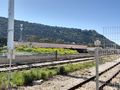
The building with the hash inside it, as photographed from the end of the train platform. Still abandoned, and does not look promising.
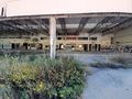
The tower of the central bus station, which probably had offices in it at some point.
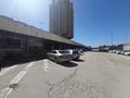
Surprising parking lot! The abandoned building is accessible! I hear barking dogs to my left. Let's not go that way.
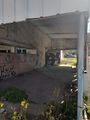
The point is in this building.
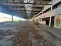
Photograph of the rest of the building, from the point
The corner of the room, where the point is
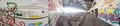
Panorama at the point.
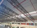
Cables hanging from the ceiling that were presumably used for bus maintenance, somehow. I know nothing of bus maintenance.
I'm guessing these channels in the ground used to hold massive jacks to lift the buses.
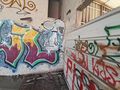
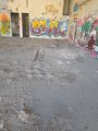
From the outside, a view of the white shed on the western edge of the building. I went in to that weird 104 graffiti area, just in case the point was on this side of the wall (but it's almost certainly on the other side).
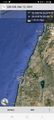
Proof that I was in Beirut the whole time


