Difference between revisions of "2024-03-31 52 21"
m (Location) |
|||
| Line 75: | Line 75: | ||
[[Category:Expeditions with photos]] | [[Category:Expeditions with photos]] | ||
[[Category:Coordinates reached]] | [[Category:Coordinates reached]] | ||
| + | {{location|PL|W|A}} | ||
Latest revision as of 22:42, 31 March 2024
| Sun 31 Mar 2024 in 52,21: 52.2181345, 21.1164243 geohashing.info google osm bing/os kml crox |
Location
Overgrown field in Las, subdistrict of Wawer district in Warsaw.
Participants
Plans
- 31/03/2024, 22:04 - Ziemek checked the hash for today. It's 16 kilometers from his flat. Go? Don't go?
- 31/03/2024, 22:18 - Go!
Expedition
It was a very pleasant night drive through Warsaw. Everyone are in their homes for easter, so the ride was quick and relaxing. Before the ride I thoroughly checked Google Maps to be sure, that my geohashing today will be succesful. But after I arrived at the place I saw a fence made with metal wires and wooden stakes. "Great!". But! After some investigation I found out, that the fenced lot was closed only from two sides, and the hash was beside it. So I begun the ritual GPS dance while blazing the trail through tall, dry weed. Ground was very crackly, so I startled few pheasants (and myself too!). Some adjusting later I found the sweet spot, took some pictures with my trusty Panasonic DMC-LZ3 (retro!) and drove home.
Tracklog
Photos
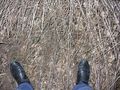
I'm here!

Coords
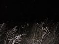
What a view!

Stupid Grin™

Price for hashing
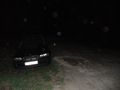
Trusty Old BMW

On my way home


Achievements
Ziemek earned the Land geohash achievement
|