Difference between revisions of "2024-04-07 52 13"
(init) |
(fill in) |
||
| Line 1: | Line 1: | ||
| − | <!-- | + | <!-- |
| − | |||
[[Image:{{{image|IMAGE}}}|thumb|left]] | [[Image:{{{image|IMAGE}}}|thumb|left]] | ||
Remove this section if you don't want an image at the top (left) of your report. You should remove the "Image:" or "File:" | Remove this section if you don't want an image at the top (left) of your report. You should remove the "Image:" or "File:" | ||
tag from your image file name, and replace the all upper-case word IMAGE in the above line. | tag from your image file name, and replace the all upper-case word IMAGE in the above line. | ||
| − | |||
| − | |||
-->{{meetup graticule | -->{{meetup graticule | ||
| lat={{#explode:{{SUBPAGENAME}}| |1}} | | lat={{#explode:{{SUBPAGENAME}}| |1}} | ||
| Line 13: | Line 10: | ||
}}<!-- edit as necessary --> | }}<!-- edit as necessary --> | ||
== Location == | == Location == | ||
| − | + | In a forest near (not in!) the [https://de.wikipedia.org/wiki/Erpetal Erpetal protected area] in [https://en.wikipedia.org/wiki/Hoppegarten Hoppegarten] | |
== Participants == | == Participants == | ||
| − | + | * [[User:HeNeArXn|HeNeArXn]] ([[User talk:HeNeArXn|talk]]) | |
| − | |||
== Plans == | == Plans == | ||
| − | + | The hash is somewhat inbetween the S-Bahn stops of Friedrichshagen and Hoppegarten, and the small river Erpe almost flows between the two, often with footpaths along it, through some protected nature areas. Take train to one of the stops, walk to hash, walk to other stop, train home. | |
== Expedition == | == Expedition == | ||
| − | + | Mostly as planned. Starting in Friedrichshagen a short bit through a park, then following the river/canal first through some residential/garden areas and then through open areas in the protected area. With the great weather there were of course quite a few other people out and about, walking, biking, picnicking or walking their dogs and ponys. A bit before the hash I turned left onto paths in the forest, following them until as close as possible to the hash. From there it was ~40-50m off the path, but the undergrowth wasn't very dense and thus quite easy to traverse. Once I had found the hash point, I returned to the path and continued on. Fewer people here until I hit the edge of town. Sadly it wasn't possible to continue along the river valley as much here (I tried, and hit a fenced-off dead end), instead following paths alongside roads up to the train stop. | |
== Tracklog == | == Tracklog == | ||
| Line 33: | Line 29: | ||
--> | --> | ||
<gallery perrow="5"> | <gallery perrow="5"> | ||
| + | File:2024-04-07 52 13 view.jpg | surroundings of the hash point | ||
| + | Image:2024-04-07 52 13 screenshot.png | proof | ||
</gallery> | </gallery> | ||
| Line 40: | Line 38: | ||
__NOTOC__ | __NOTOC__ | ||
| − | |||
| − | |||
| − | |||
| − | |||
| − | |||
| − | |||
| − | |||
| − | |||
| − | |||
| − | |||
| − | |||
| − | |||
| − | |||
[[Category:Expeditions]] | [[Category:Expeditions]] | ||
| − | |||
[[Category:Expeditions with photos]] | [[Category:Expeditions with photos]] | ||
| − | + | <!-- | |
[[Category:Expedition without GPS]] | [[Category:Expedition without GPS]] | ||
--> | --> | ||
| − | + | ||
[[Category:Coordinates reached]] | [[Category:Coordinates reached]] | ||
| − | |||
| − | |||
| − | |||
| − | |||
| − | |||
| − | |||
| − | |||
| − | |||
| − | |||
| − | |||
| − | |||
| − | |||
| − | |||
| − | |||
| − | |||
| − | |||
| − | |||
| − | |||
Revision as of 18:25, 7 April 2024
| Sun 7 Apr 2024 in 52,13: 52.4849472, 13.6388764 geohashing.info google osm bing/os kml crox |
Location
In a forest near (not in!) the Erpetal protected area in Hoppegarten
Participants
Plans
The hash is somewhat inbetween the S-Bahn stops of Friedrichshagen and Hoppegarten, and the small river Erpe almost flows between the two, often with footpaths along it, through some protected nature areas. Take train to one of the stops, walk to hash, walk to other stop, train home.
Expedition
Mostly as planned. Starting in Friedrichshagen a short bit through a park, then following the river/canal first through some residential/garden areas and then through open areas in the protected area. With the great weather there were of course quite a few other people out and about, walking, biking, picnicking or walking their dogs and ponys. A bit before the hash I turned left onto paths in the forest, following them until as close as possible to the hash. From there it was ~40-50m off the path, but the undergrowth wasn't very dense and thus quite easy to traverse. Once I had found the hash point, I returned to the path and continued on. Fewer people here until I hit the edge of town. Sadly it wasn't possible to continue along the river valley as much here (I tried, and hit a fenced-off dead end), instead following paths alongside roads up to the train stop.
Tracklog
Photos
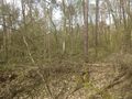
surroundings of the hash point

proof

