Difference between revisions of "2024-04-14 58 5"
From Geohashing
(→Participants) |
(→Expedition) |
||
| (12 intermediate revisions by the same user not shown) | |||
| Line 12: | Line 12: | ||
| date=2024-04-14 | | date=2024-04-14 | ||
}}<!-- edit as necessary --> | }}<!-- edit as necessary --> | ||
| + | [[Image:20240414 58 5 Me.jpg|thumb|left]] | ||
== Location == | == Location == | ||
<!-- where you've surveyed the hash to be --> | <!-- where you've surveyed the hash to be --> | ||
| + | |||
| + | A short distance from a construction road at Hellvik, Egersund, Norway. | ||
== Participants == | == Participants == | ||
| Line 26: | Line 29: | ||
== Expedition == | == Expedition == | ||
<!-- how it all turned out. your narrative goes here. --> | <!-- how it all turned out. your narrative goes here. --> | ||
| + | |||
| + | It was now three months since I last went out to find a geohash point. It was a nice trip with good weather, a little wind and with 9 °C. I had to cross a wet and dirty area with several tracks of excavators on the way to the hash. | ||
== Tracklog == | == Tracklog == | ||
| Line 35: | Line 40: | ||
--> | --> | ||
<gallery perrow="5"> | <gallery perrow="5"> | ||
| − | |||
Image:2024-04-14_58_5_Pica42_1713101709996.jpg|Hellvik [https://openstreetmap.org/?mlat=58.48389310&mlon=5.86111140&zoom=16 @58.4839,5.8611] | Image:2024-04-14_58_5_Pica42_1713101709996.jpg|Hellvik [https://openstreetmap.org/?mlat=58.48389310&mlon=5.86111140&zoom=16 @58.4839,5.8611] | ||
| + | Image:20240414_58 5 N.jpg|thumb|View to the north | ||
| + | Image:20240414_58 5 V.jpg|thumb|View to the west | ||
| + | Image:20240414 58 56 S.jpg|thumb|View to the south | ||
| + | Image:20240414 58 5 E.jpg|thumb|View to the east | ||
</gallery> | </gallery> | ||
| Line 43: | Line 51: | ||
<!-- Add any achievement ribbons you earned below, or remove this section --> | <!-- Add any achievement ribbons you earned below, or remove this section --> | ||
| − | + | {{land geohash |name=[[User:Pica42|Pica42]] |date=2024-04-14 |latitude=58 |longitude=5 }} | |
| − | |||
| − | |||
| − | [[ | ||
| − | |||
| − | |||
| − | |||
| − | |||
| − | |||
| − | |||
| − | |||
| − | |||
| − | |||
| − | |||
| − | |||
[[Category:Expeditions]] | [[Category:Expeditions]] | ||
| − | |||
[[Category:Expeditions with photos]] | [[Category:Expeditions with photos]] | ||
| − | |||
| − | |||
| − | |||
| − | |||
| − | |||
[[Category:Coordinates reached]] | [[Category:Coordinates reached]] | ||
| + | {{location|NO|11}} | ||
| − | + | __NOTOC__ | |
| − | |||
| − | |||
| − | |||
| − | |||
| − | |||
| − | |||
| − | |||
| − | |||
| − | |||
| − | |||
| − | |||
| − | |||
| − | |||
| − | |||
| − | |||
Latest revision as of 16:15, 14 April 2024
| Sun 14 Apr 2024 in 58,5: 58.4838776, 5.8611153 geohashing.info google osm bing/os kml crox |

Location
A short distance from a construction road at Hellvik, Egersund, Norway.
Participants
Plans
Expedition
It was now three months since I last went out to find a geohash point. It was a nice trip with good weather, a little wind and with 9 °C. I had to cross a wet and dirty area with several tracks of excavators on the way to the hash.
Tracklog
Photos

Hellvik @58.4839,5.8611
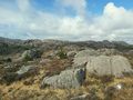
View to the north
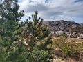
View to the west
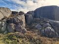
View to the south
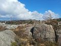
View to the east


Achievements
Pica42 earned the Land geohash achievement
|