Difference between revisions of "2024-04-14 58 5"
From Geohashing
(→Photos) |
(→Photos) |
||
| Line 38: | Line 38: | ||
<gallery perrow="5"> | <gallery perrow="5"> | ||
Image:2024-04-14_58_5_Pica42_1713101709996.jpg|Hellvik [https://openstreetmap.org/?mlat=58.48389310&mlon=5.86111140&zoom=16 @58.4839,5.8611] | Image:2024-04-14_58_5_Pica42_1713101709996.jpg|Hellvik [https://openstreetmap.org/?mlat=58.48389310&mlon=5.86111140&zoom=16 @58.4839,5.8611] | ||
| − | Image:20240414_58 5 N.jpg|thumb | + | Image:20240414_58 5 N.jpg|thumb|View to the north |
| − | + | Image:20240414_58 5 V.jpg|thumb|View to the west | |
Revision as of 15:59, 14 April 2024
| Sun 14 Apr 2024 in 58,5: 58.4838776, 5.8611153 geohashing.info google osm bing/os kml crox |
Location
A short distance from a construction road at Hellvik, Egersund, Norway.
Participants
Plans
Expedition
Tracklog
Photos

Hellvik @58.4839,5.8611
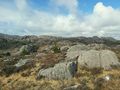
View to the north
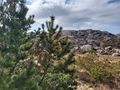
View to the west


Achievements
Pica42 earned the Land geohash achievement
|