Difference between revisions of "2024-04-22 34 -118"
From Geohashing
(An expedition message sent via Geohash Droid for Android.) |
m (Location) |
||
| (7 intermediate revisions by 2 users not shown) | |||
| Line 1: | Line 1: | ||
| − | + | {{meetup graticule | |
| − | |||
| − | |||
| − | |||
| − | |||
| − | |||
| − | |||
| − | |||
| − | |||
| lat=34 | | lat=34 | ||
| lon=-118 | | lon=-118 | ||
| date=2024-04-22 | | date=2024-04-22 | ||
| − | }} | + | }} |
== Location == | == Location == | ||
<!-- where you've surveyed the hash to be --> | <!-- where you've surveyed the hash to be --> | ||
| + | In the driveway of a house on Ontare Rd. in Arcadia, CA. | ||
== Participants == | == Participants == | ||
| − | + | *[[User:Bravissimo594|Bravissimo594]] | |
| − | |||
== Plans == | == Plans == | ||
<!-- what were the original plans --> | <!-- what were the original plans --> | ||
| + | *I will try to stop by this point (in a residential area of northern Arcadia, CA) at about 4:15pm. [[User:Bravissimo594|Bravissimo594]] ([[User talk:Bravissimo594|talk]]) 19:10, 22 April 2024 (UTC) | ||
== Expedition == | == Expedition == | ||
<!-- how it all turned out. your narrative goes here. --> | <!-- how it all turned out. your narrative goes here. --> | ||
| − | |||
| − | |||
| − | |||
== Photos == | == Photos == | ||
| Line 33: | Line 23: | ||
--> | --> | ||
<gallery perrow="5"> | <gallery perrow="5"> | ||
| + | |||
| + | Image:2024-04-22_34_-118_Bravissimo594_1713828004649.jpg|Success! | ||
| + | |||
| + | Image:2024-04-22_34_-118_Bravissimo594_1713828062662.jpg|Left a poster at the spot | ||
</gallery> | </gallery> | ||
| Line 40: | Line 34: | ||
__NOTOC__ | __NOTOC__ | ||
| − | |||
| − | |||
| − | |||
| − | |||
| − | |||
| − | |||
| − | |||
| − | |||
| − | |||
| − | |||
| − | |||
| − | |||
| − | |||
| − | |||
[[Category:Expeditions]] | [[Category:Expeditions]] | ||
| − | |||
[[Category:Expeditions with photos]] | [[Category:Expeditions with photos]] | ||
| − | |||
| − | |||
| − | |||
| − | |||
| − | |||
[[Category:Coordinates reached]] | [[Category:Coordinates reached]] | ||
| − | + | {{location|US|CA|LO}} | |
| − | |||
| − | |||
| − | |||
| − | |||
| − | |||
| − | |||
| − | |||
| − | |||
| − | |||
| − | |||
| − | |||
| − | |||
| − | |||
| − | |||
| − | |||
| − | |||
| − | |||
Latest revision as of 00:42, 30 April 2024
| Mon 22 Apr 2024 in 34,-118: 34.1576261, -118.0307729 geohashing.info google osm bing/os kml crox |
Location
In the driveway of a house on Ontare Rd. in Arcadia, CA.
Participants
Plans
- I will try to stop by this point (in a residential area of northern Arcadia, CA) at about 4:15pm. Bravissimo594 (talk) 19:10, 22 April 2024 (UTC)
Expedition
Photos
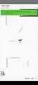
Success!
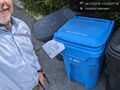
Left a poster at the spot

