Difference between revisions of "2024-04-25 47 -122"
Coyotebush (talk | contribs) ([live] Was already downtown for the morning. Caught a 545.) |
Coyotebush (talk | contribs) (some better words) |
||
| (8 intermediate revisions by 2 users not shown) | |||
| Line 11: | Line 11: | ||
| lon=-122 | | lon=-122 | ||
| date=2024-04-25 | | date=2024-04-25 | ||
| + | | graticule_name=Seattle | ||
| + | | graticule_link=Seattle, Washington | ||
}}<!-- edit as necessary --> | }}<!-- edit as necessary --> | ||
== Location == | == Location == | ||
<!-- where you've surveyed the hash to be --> | <!-- where you've surveyed the hash to be --> | ||
| + | A cul de sac in Redmond, south of Grass Lawn Park. | ||
== Participants == | == Participants == | ||
<!-- who attended: If you link to your wiki user name in this section, your expedition will be picked up by the various statistics generated for geohashing. You may use three tildes ~ as a shortcut to automatically insert the user signature of the account you are editing with. | <!-- who attended: If you link to your wiki user name in this section, your expedition will be picked up by the various statistics generated for geohashing. You may use three tildes ~ as a shortcut to automatically insert the user signature of the account you are editing with. | ||
--> | --> | ||
| + | |||
| + | * [[User:Coyotebush|coyotebush]] | ||
== Plans == | == Plans == | ||
<!-- what were the original plans --> | <!-- what were the original plans --> | ||
| + | |||
| + | All day rain, so definitely transit over bike. Nearby Old Redmond Rd is served by King County Metro route 245 every 15 minutes on weekdays (as well as route 225 hourly); 148th Ave NE to the east additionally has route 221 and the RapidRide B Line. In any case, this would be a three-seat ride from my home (i.e. require two transfers), which is a bit of a slog. However, I had already planned to take transit to downtown Seattle for the morning, whence the hash would only be a two-seat ride. So two destinations for six seats overall, not so bad. | ||
== Expedition == | == Expedition == | ||
<!-- how it all turned out. your narrative goes here. --> | <!-- how it all turned out. your narrative goes here. --> | ||
| + | Chilly in the storm - maybe should have worn a heavier coat. I tried a new lunch spot downtown and emerged just in time to catch a Sound Transit route 545 express bus taking the freeways towards Redmond. | ||
*Was already downtown for the morning. Caught a 545. -- [[User:Coyotebush|Coyotebush]] ([[User talk:Coyotebush|talk]]) [https://openstreetmap.org/?mlat=47.61336152&mlon=-122.33611705&zoom=16 @47.6134,-122.3361] 12:59, 25 April 2024 (PDT) | *Was already downtown for the morning. Caught a 545. -- [[User:Coyotebush|Coyotebush]] ([[User talk:Coyotebush|talk]]) [https://openstreetmap.org/?mlat=47.61336152&mlon=-122.33611705&zoom=16 @47.6134,-122.3361] 12:59, 25 April 2024 (PDT) | ||
| + | |||
| + | Transferred to the 245 at [[wikipedia:Redmond Technology station|Redmond Technology station]], which will also have light rail service starting on Saturday. Then a short walk into a quiet neighborhood. Seemed less chilly out there. | ||
| + | |||
| + | I could have retraced my route to Redmond Technology, but since Google Maps said it was barely slower I opted to continue west on the 245 for variety. But first I ventured into the park to find a restroom. Transferred to the 255 towards Seattle a few stops short of downtown Kirkland, which turned out to be right next to Google's Kirkland campus. | ||
| + | |||
== Tracklog == | == Tracklog == | ||
| − | + | Walk: bus to hash to restroom to bus | |
| + | |||
| + | {{Tracklog|2024-04-25 47 -122 walk.gpx}} | ||
== Photos == | == Photos == | ||
| Line 34: | Line 49: | ||
Image:2020-##-## ## ## Alpha.jpg | Witty Comment | Image:2020-##-## ## ## Alpha.jpg | Witty Comment | ||
--> | --> | ||
| − | <gallery perrow=" | + | <gallery perrow="3"> |
| + | |||
| + | Image:2024-04-25_47_-122_coyotebush_1714076429312.jpg|Bus transfer next to nearly open light rail station [https://openstreetmap.org/?mlat=47.64470165&mlon=-122.13320012&zoom=16 @47.6447,-122.1332] | ||
| + | |||
| + | |||
| + | |||
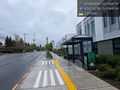
| + | Image:2024-04-25_47_-122_coyotebush_1714082934456.jpg|The street [https://openstreetmap.org/?mlat=47.66392778&mlon=-122.14681111&zoom=16 @47.6639,-122.1468] | ||
| + | |||
| + | Image:2024-04-25_47_-122_coyotebush_1714083010743.jpg|Map | ||
| + | |||
| + | Image:2024-04-25_47_-122_coyotebush_1714082960521.jpg|Hasher [https://openstreetmap.org/?mlat=47.66333889&mlon=-122.14693611&zoom=16 @47.6633,-122.1469] | ||
| + | |||
| + | Image:2024-04-25_47_-122_coyotebush_1714082996691.jpg|Park [https://openstreetmap.org/?mlat=47.66712222&mlon=-122.14711944&zoom=16 @47.6671,-122.1471] | ||
| + | |||
| + | Image:2024-04-25_47_-122_coyotebush_1714079798856.jpg|Return bus transfer next to Google campus [https://openstreetmap.org/?mlat=47.67146932&mlon=-122.19645154&zoom=16 @47.6715,-122.1965] | ||
</gallery> | </gallery> | ||
| Line 40: | Line 69: | ||
{{#vardefine:ribbonwidth|100%}} | {{#vardefine:ribbonwidth|100%}} | ||
<!-- Add any achievement ribbons you earned below, or remove this section --> | <!-- Add any achievement ribbons you earned below, or remove this section --> | ||
| + | |||
| + | {{Public transport geohash | latitude = 47 | longitude = -122 | date = 2024-04-25 | name = coyotebush }} | ||
__NOTOC__ | __NOTOC__ | ||
| − | |||
| − | |||
| − | |||
| − | |||
| − | |||
| − | |||
| − | |||
| − | |||
| − | |||
| − | |||
| − | |||
| − | |||
| − | |||
[[Category:Expeditions]] | [[Category:Expeditions]] | ||
| − | |||
[[Category:Expeditions with photos]] | [[Category:Expeditions with photos]] | ||
| − | |||
| − | |||
| − | |||
| − | |||
| − | |||
[[Category:Coordinates reached]] | [[Category:Coordinates reached]] | ||
| − | + | {{location|US|WA|KN}} | |
| − | |||
| − | |||
| − | |||
| − | |||
| − | |||
| − | |||
| − | |||
| − | |||
| − | |||
| − | |||
| − | |||
| − | |||
| − | |||
| − | |||
| − | |||
| − | |||
| − | |||
Latest revision as of 04:22, 26 April 2024
| Thu 25 Apr 2024 in Seattle: 47.6633315, -122.1469066 geohashing.info google osm bing/os kml crox |
Location
A cul de sac in Redmond, south of Grass Lawn Park.
Participants
Plans
All day rain, so definitely transit over bike. Nearby Old Redmond Rd is served by King County Metro route 245 every 15 minutes on weekdays (as well as route 225 hourly); 148th Ave NE to the east additionally has route 221 and the RapidRide B Line. In any case, this would be a three-seat ride from my home (i.e. require two transfers), which is a bit of a slog. However, I had already planned to take transit to downtown Seattle for the morning, whence the hash would only be a two-seat ride. So two destinations for six seats overall, not so bad.
Expedition
Chilly in the storm - maybe should have worn a heavier coat. I tried a new lunch spot downtown and emerged just in time to catch a Sound Transit route 545 express bus taking the freeways towards Redmond.
- Was already downtown for the morning. Caught a 545. -- Coyotebush (talk) @47.6134,-122.3361 12:59, 25 April 2024 (PDT)
Transferred to the 245 at Redmond Technology station, which will also have light rail service starting on Saturday. Then a short walk into a quiet neighborhood. Seemed less chilly out there.
I could have retraced my route to Redmond Technology, but since Google Maps said it was barely slower I opted to continue west on the 245 for variety. But first I ventured into the park to find a restroom. Transferred to the 255 towards Seattle a few stops short of downtown Kirkland, which turned out to be right next to Google's Kirkland campus.
Tracklog
Walk: bus to hash to restroom to bus
Photos
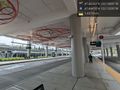
Bus transfer next to nearly open light rail station @47.6447,-122.1332
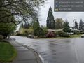
The street @47.6639,-122.1468
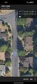
Map
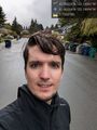
Hasher @47.6633,-122.1469
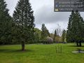
Park @47.6671,-122.1471
Return bus transfer next to Google campus @47.6715,-122.1965


Achievements
coyotebush earned the Public transport geohash achievement
|