Difference between revisions of "2024-04-29 49 11"
([live picture]Proof) |
m (Location) |
||
| (2 intermediate revisions by one other user not shown) | |||
| Line 14: | Line 14: | ||
== Location == | == Location == | ||
<!-- where you've surveyed the hash to be --> | <!-- where you've surveyed the hash to be --> | ||
| + | Near the Main-Donau canal in Nuremberg. | ||
== Participants == | == Participants == | ||
<!-- who attended: If you link to your wiki user name in this section, your expedition will be picked up by the various statistics generated for geohashing. You may use three tildes ~ as a shortcut to automatically insert the user signature of the account you are editing with. | <!-- who attended: If you link to your wiki user name in this section, your expedition will be picked up by the various statistics generated for geohashing. You may use three tildes ~ as a shortcut to automatically insert the user signature of the account you are editing with. | ||
--> | --> | ||
| + | [[User:Torodeas|Torodeas]] ([[User talk:Torodeas|talk]]) | ||
| − | == | + | == Expedition == |
| − | + | A very convenient hash for me: I can visit it on my way home from work. | |
| + | I've almost been there before, as one of the better cycling routes around here follows the canal. | ||
| + | I won't claim a [[Déjà vu geohash achievement]] because the hash is approx 100 meters inside a wooded area I haven't been to before, | ||
| + | and I don't have a tracklog or other proof for these cycling tours anyways. | ||
| + | |||
| + | It's a warm day when I leave for the hash. A bit too warm for my taste, since I haven't mentally arrived in summer. I will get used to it. | ||
| + | I depart work southbound to Nuremberg, change thrice and arrive relatively quickly at Rotterdamer Straße. | ||
| + | After a quick search how to get down to the canal on its eastern side, where the hash is, I arrive on the mixed walking / cycling route I am so used to. Walking along the canal takes longer than I am used to, since I am usually here by bike. And there is no shade on that path, so the sun burns down mercilessly. I am relieved once I can enter the small wooded area to cool down a bit. | ||
| + | |||
| + | The hash does take some time to locate precisely. I am not in a rush, so I take the time (and my compass) to get a very precise reading. That might be the closest reading I've ever had, at less than 20cm. Satisfied, I walk back to the bus stop to get home | ||
| − | |||
<!-- how it all turned out. your narrative goes here. --> | <!-- how it all turned out. your narrative goes here. --> | ||
| Line 39: | Line 49: | ||
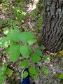
Image:2024-04-29_49_11_Torodeas_1714405217953.jpg|Proof | Image:2024-04-29_49_11_Torodeas_1714405217953.jpg|Proof | ||
| + | |||
| + | Image:2024-04-29_49_11_Torodeas_1714405282237.jpg|Bus stop Rotterdamer Straße | ||
</gallery> | </gallery> | ||
| Line 44: | Line 56: | ||
{{#vardefine:ribbonwidth|100%}} | {{#vardefine:ribbonwidth|100%}} | ||
<!-- Add any achievement ribbons you earned below, or remove this section --> | <!-- Add any achievement ribbons you earned below, or remove this section --> | ||
| + | {{land geohash | ||
| + | | date = 2024-04-29 | ||
| + | | latitude = 49 | ||
| + | | longitude = 11 | ||
| + | | name = Torodeas | ||
| + | }} | ||
| + | {{Public transport geohash | ||
| + | | date = 2024-04-29 | ||
| + | | latitude = 49 | ||
| + | | longitude = 11 | ||
| + | | name = Torodeas | ||
| + | | busline = 20, 10, U2, 67 | ||
| + | }} | ||
__NOTOC__ | __NOTOC__ | ||
<!-- =============== USEFUL CATEGORIES FOLLOW ================ | <!-- =============== USEFUL CATEGORIES FOLLOW ================ | ||
Delete the next line ONLY if you have chosen the appropriate categories below. If you are unsure, don't worry. People will read your report and help you with the classification. --> | Delete the next line ONLY if you have chosen the appropriate categories below. If you are unsure, don't worry. People will read your report and help you with the classification. --> | ||
| − | [[Category: | + | [[Category:Expeditions]] |
| + | [[Category:Expeditions with photos]] | ||
| + | [[Category:Coordinates reached]] | ||
<!-- ==REQUEST FOR TWITTER BOT== Please leave either the New report or the Expedition planning category in as long as you work on it. This helps the twitter bot a lot with announcing the right outcome at the right moment. --> | <!-- ==REQUEST FOR TWITTER BOT== Please leave either the New report or the Expedition planning category in as long as you work on it. This helps the twitter bot a lot with announcing the right outcome at the right moment. --> | ||
| Line 87: | Line 114: | ||
(Don't forget to delete this final close comment marker) --> | (Don't forget to delete this final close comment marker) --> | ||
| + | {{location|DE|BY|N}} | ||
Latest revision as of 06:42, 17 May 2024
| Mon 29 Apr 2024 in 49,11: 49.3984322, 11.0706924 geohashing.info google osm bing/os kml crox |
Location
Near the Main-Donau canal in Nuremberg.
Participants
Expedition
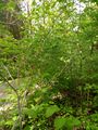
A very convenient hash for me: I can visit it on my way home from work. I've almost been there before, as one of the better cycling routes around here follows the canal. I won't claim a Déjà vu geohash achievement because the hash is approx 100 meters inside a wooded area I haven't been to before, and I don't have a tracklog or other proof for these cycling tours anyways.
It's a warm day when I leave for the hash. A bit too warm for my taste, since I haven't mentally arrived in summer. I will get used to it. I depart work southbound to Nuremberg, change thrice and arrive relatively quickly at Rotterdamer Straße. After a quick search how to get down to the canal on its eastern side, where the hash is, I arrive on the mixed walking / cycling route I am so used to. Walking along the canal takes longer than I am used to, since I am usually here by bike. And there is no shade on that path, so the sun burns down mercilessly. I am relieved once I can enter the small wooded area to cool down a bit.
The hash does take some time to locate precisely. I am not in a rush, so I take the time (and my compass) to get a very precise reading. That might be the closest reading I've ever had, at less than 20cm. Satisfied, I walk back to the bus stop to get home
Tracklog
Photos
At the hash
View from hash

Proof
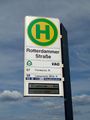
Bus stop Rotterdamer Straße


Achievements
Torodeas earned the Land geohash achievement
|
Torodeas earned the Public transport geohash achievement
|