Difference between revisions of "2024-05-04 62 26"
(Created page with "{{subst:expedition}}") |
m (Location) |
||
| (5 intermediate revisions by one other user not shown) | |||
| Line 1: | Line 1: | ||
| − | + | {{meetup graticule | |
| − | |||
| − | |||
| − | |||
| − | |||
| − | |||
| − | |||
| − | |||
| − | |||
| lat={{#explode:{{SUBPAGENAME}}| |1}} | | lat={{#explode:{{SUBPAGENAME}}| |1}} | ||
| lon={{#explode:{{SUBPAGENAME}}| |2}} | | lon={{#explode:{{SUBPAGENAME}}| |2}} | ||
| date={{#explode:{{SUBPAGENAME}}| |0}} | | date={{#explode:{{SUBPAGENAME}}| |0}} | ||
| − | }} | + | }} |
== Location == | == Location == | ||
| − | + | In a forest near Sonkari, Vesanto. | |
| + | |||
| + | The point on a topographic map: [https://kripakko.neocities.org/geohash_maplink?{{#replace:{{SUBPAGENAME}}| |_}}K] | ||
== Participants == | == Participants == | ||
| − | + | * [[User:Kripakko|Kripakko]] | |
| − | |||
| − | == | + | == Expedition == |
| − | + | I was spending the weekend here in [[62,26]], and this hashpoint happened to be located within 20 kilometres in a decently accessible place. | |
| + | I decided to go driving in the afternoon, park to the nearest convenient point and walk to the point. | ||
| + | Should be an easy feat and a nice excuse to explore the outdoors. | ||
| − | + | I tried to take the shortest route via a field road, but it ended up being so uneven and soft that I did not dare to drive through it. | |
| − | + | Had the road surface been frozen, I might have been able to make it, but as it was, I reckoned that the risk of getting stuck was too high. | |
| + | I then reversed a couple hundred metres and took a longer route which was nice and safe. | ||
| + | The rest of the drive went without issues. | ||
| + | Rasputitsa had made some stretches of the unpaved road considerably bumpy but not too bad. | ||
| + | It is a yearly occurrence, and I am used to it. | ||
| − | + | I parked the car to a convenient wide part off the final forest road. | |
| − | + | I could pretty easily walk to the hashpoint and back, though there were some snowy or wet areas and more or less loose rocks that I needed to be careful with. | |
| + | Almost all snow had already melted during the warm days of the spring. | ||
| + | In fact, it was a rather warm (around 12 °C) and sunny day, and the nature looked beautiful after the long winter. | ||
| + | I could not resist taking a lot of photos. | ||
== Photos == | == Photos == | ||
| − | < | + | <gallery perrow="12"> |
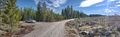
| − | Image: | + | Image:2024-05-04_62_26_01-softroad.jpg | The soft field road through which I did not dare to drive. |
| − | -- | + | Image:2024-05-04_62_26_02-swans.jpg | A pair of whooper swans (''Cygnus cygnus''). |
| − | < | + | Image:2024-05-04_62_26_03-coltsfeet.jpg | Blossoming coltsfeet (''Tussilago farfara''). |
| + | Image:2024-05-04_62_26_04-junction.jpg | The car temporarily parked near a road junction. | ||
| + | Image:2024-05-04_62_26_05-parked.jpg | The car parked where I continued on foot, about 240 metres to go. | ||
| + | Image:2024-05-04_62_26_06-usnea.jpg | Lots of beard lichen (''Usnea'' sp.) growing on the spruces. | ||
| + | Image:2024-05-04_62_26_07-lingonberry.jpg | A lingonberry that had survived the winter. Not edible, though some­times these can be. | ||
| + | Image:2024-05-04_62_26_08-selfie.jpg | Hashpoint reached, Stupid Grin™ | ||
| + | Image:2024-05-04_62_26_09-qdgn.png | Proof of location and time, screen­shot of [https://kripakko.neocities.org/qdgn QDGN]. | ||
| + | Image:2024-05-04_62_26_10-lichen.jpg | Lichens, mosses and subshrubs growing on some rocks.<!-- I'm too lazy to list the species :D --> | ||
| + | Image:2024-05-04_62_26_11-manure.jpg | Elk (''Alces alces'') manure, one of several piles that I saw. | ||
| + | Image:2024-05-04_62_26_12-lake.jpg | View to lake Kute­mai­nen. This bay was still covered in ice. | ||
</gallery> | </gallery> | ||
== Achievements == | == Achievements == | ||
| − | {{# | + | {{land geohash |
| − | + | | latitude={{#explode:{{SUBPAGENAME}}| |1}} | |
| + | | longitude={{#explode:{{SUBPAGENAME}}| |2}} | ||
| + | | date={{#explode:{{SUBPAGENAME}}| |0}} | ||
| + | | name=[[User:Kripakko|Kripakko]] | ||
| + | }} | ||
__NOTOC__ | __NOTOC__ | ||
| − | |||
| − | |||
| − | |||
| − | |||
| − | |||
| − | |||
| − | |||
| − | |||
| − | |||
| − | |||
| − | |||
| − | |||
| − | |||
[[Category:Expeditions]] | [[Category:Expeditions]] | ||
| − | |||
[[Category:Expeditions with photos]] | [[Category:Expeditions with photos]] | ||
| − | |||
| − | |||
| − | |||
| − | |||
| − | |||
[[Category:Coordinates reached]] | [[Category:Coordinates reached]] | ||
| − | + | {{location|FI|15}} | |
| − | |||
| − | |||
| − | |||
| − | |||
| − | |||
| − | |||
| − | |||
| − | |||
| − | |||
| − | |||
| − | |||
| − | |||
| − | |||
| − | |||
| − | |||
| − | |||
| − | |||
Latest revision as of 19:42, 5 May 2024
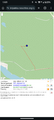
| Sat 4 May 2024 in 62,26: 62.8657128, 26.4690160 geohashing.info google osm bing/os kml crox |
Location
In a forest near Sonkari, Vesanto.
The point on a topographic map: [1]
Participants
Expedition
I was spending the weekend here in 62,26, and this hashpoint happened to be located within 20 kilometres in a decently accessible place. I decided to go driving in the afternoon, park to the nearest convenient point and walk to the point. Should be an easy feat and a nice excuse to explore the outdoors.
I tried to take the shortest route via a field road, but it ended up being so uneven and soft that I did not dare to drive through it. Had the road surface been frozen, I might have been able to make it, but as it was, I reckoned that the risk of getting stuck was too high. I then reversed a couple hundred metres and took a longer route which was nice and safe. The rest of the drive went without issues. Rasputitsa had made some stretches of the unpaved road considerably bumpy but not too bad. It is a yearly occurrence, and I am used to it.
I parked the car to a convenient wide part off the final forest road. I could pretty easily walk to the hashpoint and back, though there were some snowy or wet areas and more or less loose rocks that I needed to be careful with. Almost all snow had already melted during the warm days of the spring. In fact, it was a rather warm (around 12 °C) and sunny day, and the nature looked beautiful after the long winter. I could not resist taking a lot of photos.
Photos
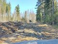
The soft field road through which I did not dare to drive.
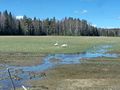
A pair of whooper swans (Cygnus cygnus).
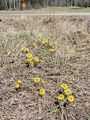
Blossoming coltsfeet (Tussilago farfara).
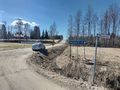
The car temporarily parked near a road junction.
The car parked where I continued on foot, about 240 metres to go.
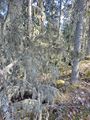
Lots of beard lichen (Usnea sp.) growing on the spruces.
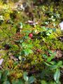
A lingonberry that had survived the winter. Not edible, though sometimes these can be.
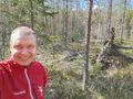
Hashpoint reached, Stupid Grin™
Proof of location and time, screenshot of QDGN.
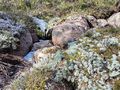
Lichens, mosses and subshrubs growing on some rocks.
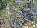
Elk (Alces alces) manure, one of several piles that I saw.
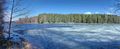
View to lake Kutemainen. This bay was still covered in ice.


Achievements
Kripakko earned the Land geohash achievement
|