Difference between revisions of "2024-05-08 34 -118"
m (Add categories) |
m (Remove thumb at top) |
||
| (5 intermediate revisions by 2 users not shown) | |||
| Line 1: | Line 1: | ||
| − | + | {{meetup graticule|lat=34|lon=-118|date=2024-05-08}} | |
| − | |||
| − | {{meetup graticule | ||
| − | | lat= | ||
| − | | lon= | ||
| − | | date= | ||
| − | }} | ||
== Location == | == Location == | ||
| − | The hash is in a dirt area off the road near Magic Mountain. Google's Street View from 6 months ago shows some piles of dirt and a freestanding gate we can walk past. Behind the hash is a ditch with a dry [https://wiki.openstreetmap.org/wiki/Tag:tunnel=culvert?uselang=en culvert] that we could also walk down. (Apple's satellite imagery is quite old, showing actual construction that no longer appears to be there.) | + | The hash is in a dirt area off the road near Magic Mountain and the new Valencia development. Google's Street View from 6 months ago shows some piles of dirt and a freestanding gate we can walk past. Behind the hash is a ditch with a dry [https://wiki.openstreetmap.org/wiki/Tag:tunnel=culvert?uselang=en culvert] that we could also walk down. (Apple's satellite imagery is quite old, showing actual construction that no longer appears to be there.) |
== Participants == | == Participants == | ||
| Line 14: | Line 8: | ||
== Plans == | == Plans == | ||
| − | This morning, I ( | + | This morning, I (Jeremy) got a notification from my geohash-calculating [https://apps.apple.com/us/app/shortcuts/id915249334 shortcut] that the geohash was accessible. My best friend Ethan and I have been waiting for months for our first hash, so this is really exciting. Today happens to be a really good day, our schedules are clear and the weather is great. There are four geocaches nearby and the Iron Horse trailhead is not far, so we will try to take our bikes down to the trailhead and bike around. |
== Expedition == | == Expedition == | ||
| − | + | We loaded up our bikes and drove down to the Iron Horse trailhead. Of course, Ethan set the mood with some rock on the way there. We prepared our bikes and set off for the geohash (you can see the start of the tracklog where I thought "hey, I should record"). We had to cross some busy intersections, but the buttons for telling the speedy Teslas (because California) to stop were functional, so all was well. As we were biking up Magic Mountain Parkway, we realised that the new development was a lot bigger than it looked on the map. Still, it wasn't very long before we arrived at the hashpoint's field. | |
| + | |||
| + | There were some No Trespassing signs, but it was just a big dirt lot. We walked across to the hashpoint, took some pictures, and congratulated ourselves on our first geohash. Interestingly, the piles of dirt we saw on Street View from November weren't there anymore, and the hill across the street had many fancy under-construction houses. The stream that OSM showed as directly under the geohash was a tad east of there, as well. When we were satisfied, we got back on our bikes and set off for the nearby Five Points neighborhood in search of geocaches. | ||
| + | |||
| + | (Warning: spoilers for geocaches) The first geocache we looked for ([https://www.geocaching.com/geocache/GCAHWQ6 GCAHWQ6]) was in this cool little pump track right by the houses. We spent 20 minutes looking around the area for this little hide-a-key rock. With the help of the hint ("Low & Under"), I (Jeremy) finally found the cheeky little cache cleverly hidden under the edge of one of the bumps (see pictures). The second geocache ([https://www.geocaching.com/geocache/GCAJR8K GCAJR8K]) was down the road at the local community center place. The page told us it was a little magnetic nano, close to the sign, though the hint never helped us. We spent another 20 minutes looking for this one, but couldn't find it. Eventually, it was too late, and we decided to head back. | ||
| + | |||
| + | The bike back to the car at the trailhead went smoothly, and we packed up our bikes, happy with our accomplishment. We did spend 10 minutes trying to start the car before we realized it was in park, however. This was a fun adventure, we hope to go for more hashes in the future. | ||
== Tracklog == | == Tracklog == | ||
| − | + | I never paused my recording, so you get to see us wandering around at the geohash and geocaches. | |
| + | {{tracklog|2024-05-08 34 -118 Jeremy's watch.gpx}} | ||
== Photos == | == Photos == | ||
| − | |||
| − | |||
| − | |||
<gallery perrow="5"> | <gallery perrow="5"> | ||
| + | Image:2024-05-08_34_-118_Jeremy_1715209856632.jpg|Arrival at the Iron Horse trailhead | ||
| + | |||
| + | Image:2024-05-08_34_-118_Jeremy_1715211259379.jpg|We made it to the geohash, [[Category:Grins|Stupid Grin]]and all! | ||
| + | Image:2024-05-08 34 -118 Ethan at the geohash.jpg|Ethan posing on top of the geohash | ||
| + | Image:2024-05-08 34 -118 Panorama of the geohash.jpg|A panorama showing the field, with new development to the left and Six Flags to the right | ||
| − | Image:2024-05-08_34_- | + | Image:2024-05-08_34_-118_Jeremy_1715211455258.jpg|Putting a [http://poster.geo.crox.net/poster/2024-05-08_34_-118 poster] on the no trespassing sign as we left. "It isn't trespassing if you don't get caught" - Jeremy |
| − | Image:2024-05- | + | Image:2024-05-08 34 -118 Adventure Avenue.jpg|We biked down Adventure Avenue on our way to the geocaches - "That's so cliché. I love it" - Ethan |
| − | Image:2024-05- | + | Image:2024-05-08 34 -118 First geocache.jpg|Can you spot the geocache? |
| + | Image:2024-05-08 34 -118 First geocache closeup.jpg|Trust me, there's a geocache under there. | ||
| + | |||
| + | File:2024-05-08 34 -118 Back down magic mtn.mov|Heading back down Magic Mountain Pkwy after a successful expedition | ||
</gallery> | </gallery> | ||
== Achievements == | == Achievements == | ||
{{#vardefine:ribbonwidth|100%}} | {{#vardefine:ribbonwidth|100%}} | ||
| − | {{land geohash | latitude = 34 | longitude = -118 | date = 2024-05-08 | name = Jeremy and Ethan }} | + | <!-- TODO: add images to achievements --> |
| + | {{land geohash | ||
| + | | latitude=34|longitude=-118|date=2024-05-08 | ||
| + | | name=[[User:Jeremy|Jeremy]] and [[User:Lehonk|Ethan]] | ||
| + | | image=2024-05-08_34_-118_Jeremy_1715211259379.jpg | ||
| + | }} | ||
| + | {{bicycle geohash | ||
| + | | latitude=34|longitude=-118|date=2024-05-08 | ||
| + | | name=[[User:Jeremy|Jeremy]] and [[User:Lehonk|Ethan]] | ||
| + | | image=2024-05-08_34_-118_Jeremy_1715211259379.jpg | ||
| + | | distance=7 miles | ||
| + | | bothways=true | ||
| + | }} | ||
| + | {{Two to the N achievement | ||
| + | | lat=34|lon=-118|date=2024-05-08 | ||
| + | | name=[[User:Jeremy|Jeremy]] and [[User:Lehonk|Ethan]] | ||
| + | | image=2024-05-08_34_-118_Jeremy_1715211259379.jpg | ||
| + | | count=0 | ||
| + | }} | ||
__NOTOC__ | __NOTOC__ | ||
| − | |||
| − | |||
[[Category:Expeditions]] | [[Category:Expeditions]] | ||
[[Category:Expeditions with photos]] | [[Category:Expeditions with photos]] | ||
| − | + | [[Category:Expeditions with videos]] | |
[[Category:Coordinates reached]] | [[Category:Coordinates reached]] | ||
| + | {{location|US|CA|LO}} | ||
Latest revision as of 07:12, 10 May 2024
| Wed 8 May 2024 in 34,-118: 34.4130363, -118.5996918 geohashing.info google osm bing/os kml crox |
Location
The hash is in a dirt area off the road near Magic Mountain and the new Valencia development. Google's Street View from 6 months ago shows some piles of dirt and a freestanding gate we can walk past. Behind the hash is a ditch with a dry culvert that we could also walk down. (Apple's satellite imagery is quite old, showing actual construction that no longer appears to be there.)
Participants
Plans
This morning, I (Jeremy) got a notification from my geohash-calculating shortcut that the geohash was accessible. My best friend Ethan and I have been waiting for months for our first hash, so this is really exciting. Today happens to be a really good day, our schedules are clear and the weather is great. There are four geocaches nearby and the Iron Horse trailhead is not far, so we will try to take our bikes down to the trailhead and bike around.
Expedition
We loaded up our bikes and drove down to the Iron Horse trailhead. Of course, Ethan set the mood with some rock on the way there. We prepared our bikes and set off for the geohash (you can see the start of the tracklog where I thought "hey, I should record"). We had to cross some busy intersections, but the buttons for telling the speedy Teslas (because California) to stop were functional, so all was well. As we were biking up Magic Mountain Parkway, we realised that the new development was a lot bigger than it looked on the map. Still, it wasn't very long before we arrived at the hashpoint's field.
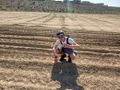
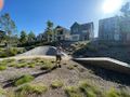
There were some No Trespassing signs, but it was just a big dirt lot. We walked across to the hashpoint, took some pictures, and congratulated ourselves on our first geohash. Interestingly, the piles of dirt we saw on Street View from November weren't there anymore, and the hill across the street had many fancy under-construction houses. The stream that OSM showed as directly under the geohash was a tad east of there, as well. When we were satisfied, we got back on our bikes and set off for the nearby Five Points neighborhood in search of geocaches.
(Warning: spoilers for geocaches) The first geocache we looked for (GCAHWQ6) was in this cool little pump track right by the houses. We spent 20 minutes looking around the area for this little hide-a-key rock. With the help of the hint ("Low & Under"), I (Jeremy) finally found the cheeky little cache cleverly hidden under the edge of one of the bumps (see pictures). The second geocache (GCAJR8K) was down the road at the local community center place. The page told us it was a little magnetic nano, close to the sign, though the hint never helped us. We spent another 20 minutes looking for this one, but couldn't find it. Eventually, it was too late, and we decided to head back.
The bike back to the car at the trailhead went smoothly, and we packed up our bikes, happy with our accomplishment. We did spend 10 minutes trying to start the car before we realized it was in park, however. This was a fun adventure, we hope to go for more hashes in the future.
Tracklog
I never paused my recording, so you get to see us wandering around at the geohash and geocaches.
Photos

Arrival at the Iron Horse trailhead

We made it to the geohash,and all!
Ethan posing on top of the geohash
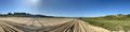
A panorama showing the field, with new development to the left and Six Flags to the right
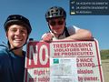
Putting a poster on the no trespassing sign as we left. "It isn't trespassing if you don't get caught" - Jeremy
We biked down Adventure Avenue on our way to the geocaches - "That's so cliché. I love it" - Ethan
Can you spot the geocache?
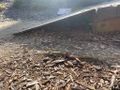
Trust me, there's a geocache under there.
Heading back down Magic Mountain Pkwy after a successful expedition


Achievements
Jeremy and Ethan earned the Land geohash achievement
|
Jeremy and Ethan earned the Bicycle geohash achievement
|
