Difference between revisions of "South Waikato, New Zealand"
From Geohashing
(→Photos) |
|||
| Line 17: | Line 17: | ||
The '''South Waikato''' [[graticule]] is located at [http://irc.peeron.com/xkcd/map/map.html?lat=-38&long=175 latitude -38, longitude 175]. | The '''South Waikato''' [[graticule]] is located at [http://irc.peeron.com/xkcd/map/map.html?lat=-38&long=175 latitude -38, longitude 175]. | ||
| + | |||
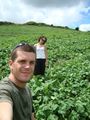
| + | {{East Geohash | ||
| + | | name=[[user:Greenslime|Greenslime]] | ||
| + | | latitude=-38 | ||
| + | | longitude=175 | ||
| + | | date=2010-01-29 | ||
| + | | image=2010 01 29 -38 175 Future easterly hashes await in this direction.jpg | ||
| + | }} | ||
| + | |||
| + | {{Virgin graticule | ||
| + | | latitude = -38 | ||
| + | | longitude = 175 | ||
| + | | date = 2010-01-29 | ||
| + | | name = Greenslime | ||
| + | | image = 2010 01 29 -38 175 Beating blackberry into submission.jpg | ||
| + | }} | ||
==Geohashes== | ==Geohashes== | ||
Revision as of 00:51, 8 June 2010
| Manukau City | Hamilton | Tauranga |
| Waitara | South Waikato | Rotorua |
| New Plymouth | Wanganui | Napier |
|
Today's location: geohashing.info google osm bing/os kml crox | ||
Today's Location: South Waikato, NZ
The South Waikato graticule is located at latitude -38, longitude 175.
Greenslime earned the East geohash achievement
|
Geohashes
- 2010-01-29 - Greenslime Farm Paddock, Near Lake Whakamaru, South Waikato
- 2010-02-01 - Greenslime Farm Paddock, Near Arataki, South Waikato
Photos
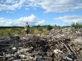
Sometimes reaching the hash is harder than it looks.
Farm Paddock, Near Arataki, South Waikato.

