Difference between revisions of "South Waikato, New Zealand"
imported>ReletBot m (Bot: Automated text replacement (-irc.peeron.com +carabiner.peeron.com)) |
imported>Fippe |
||
| Line 72: | Line 72: | ||
[[Category:New Zealand]] | [[Category:New Zealand]] | ||
| − | [[Category: | + | [[Category:Inactive graticules]] |
[[Category:Deflowered graticules]] | [[Category:Deflowered graticules]] | ||
Revision as of 07:39, 16 August 2018
This page is maintained by Greenslime. Automatic updates are not desired.
|
Latest Coordinates and Map Quick-Links | |
|---|---|
| Friday 2024-05-03 | -38.6854836, 175.0278639 |
| Manukau City | Hamilton | Tauranga |
| Waitara | South Waikato | Rotorua |
| New Plymouth | Wanganui | Napier |
|
Today's location: geohashing.info google osm bing/os kml crox | ||

Contents
Description
The South Waikato region is the heartland of the North Island and the land supplies a large proportion of locally sold and exported primary produce (wood, beef and dairy). Land use is mostly farmland and forestry, but the region does have some notable attractions including the Hotpools at Tokaanu [1], trout fishing at Turangi [2], the Kiwihouse at Otorohanga [3], and of course New Zealands largest lake, Lake Taupo.
Links
The South Waikato region even has a council website [4].
Statistics
Greenslime and JimmyNZ earned the East geohash achievement
|
Local Geohashers
an unknown quantity
Visitors
Geohashes Reached
- 2010-01-29 - Greenslime and JimmyNZ - Farm Paddock, Near Lake Whakamaru, South Waikato
- 2010-02-01 - Greenslime and JimmyNZ - Farm Paddock, Near Arataki, South Waikato
Geohashes Not Reached
Photos Gallery
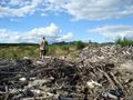
Sometimes reaching the hash is harder than it looks.
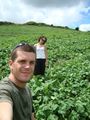
Farm Paddock, Near Arataki, South Waikato.

