Difference between revisions of "Tauranga, New Zealand"
From Geohashing
imported>Quaternary |
m (per Renaming Proposal) |
||
| (One intermediate revision by the same user not shown) | |||
| Line 1: | Line 1: | ||
| − | |||
| − | |||
{{QuickLinks|lat=-37|lon=176 | {{QuickLinks|lat=-37|lon=176 | ||
}} | }} | ||
| Line 57: | Line 55: | ||
[[Category:Inactive graticules]] | [[Category:Inactive graticules]] | ||
| − | [[Category: | + | [[Category:Unlocked graticules]] |
[[Category:New Zealand]] | [[Category:New Zealand]] | ||
Latest revision as of 02:32, 20 March 2024
|
Latest Coordinates and Map Quick-Links | |
|---|---|
| Wednesday 2024-05-22 | -37.2756314, 176.2193894 |
| Coromandel | The Alderman Islands | -36,177 |
| Hamilton | Tauranga | Waiorore |
| South Waikato | Rotorua | Opotiki |
|
Today's location: geohashing.info google osm bing/os kml crox | ||
Contents
Description
Tauranga is the most populated city in the Bay of Plenty. Notable features are Mount Maunganui and the Ports of Tauranga. The majority of the graticule comprises water, being the Firth of Thames.
Statistics
- One reached
- One not-reached
Local Geohashers
none yet
Visitors
Geohashes Reached
![]() 2016-09-06 - Fraser Cove, Tauranga Harbour
2016-09-06 - Fraser Cove, Tauranga Harbour
Geohashes Not Reached
![]() 2010-06-07 - Forestry Area, Omanawa Road, Omanawa Falls, Tauranga
2010-06-07 - Forestry Area, Omanawa Road, Omanawa Falls, Tauranga
Photo Gallery
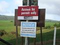
'Permit required' and 'No Trespassing' signs sighted prior to this one changed our minds about this hash
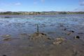
The hashpoint of 6 September, 2016.

