Difference between revisions of "Wellington, New Zealand"
From Geohashing
imported>Tjm1983 (→Photo Gallery: added 2009-05-05) |
imported>Tjm1983 m (→Photo Gallery) |
||
| Line 28: | Line 28: | ||
==Photo Gallery== | ==Photo Gallery== | ||
<gallery perrow="3"> | <gallery perrow="3"> | ||
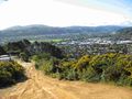
| − | Image:2009-05-05 -41 174 waving.jpeg| | + | Image:2009-05-05 -41 174 waving.jpeg| Waving from the [[2009-05-05 -41 174|2009-05-05]] hashpoint |
</gallery> | </gallery> | ||
Revision as of 01:54, 10 May 2009
| D'Urville Island | Paraparaumu | Palmerston North |
| Nelson | Wellington | Upper Hutt |
| Kaikoura | Kekerengu | -42,175 |
[[Category:Meetup in {{{lat}}} {{{lon}}}| ]]
Today's Location: Wellington, NZ
Wellington's graticule is at latitude -41, longitude 174.
Wellington is the capital city of New Zealand. This graticule is not ideal for geohashing as most of the graticule lies in the ocean, and that which does not is divided evenly between the North Island, the South Island, and inaccessible land in the Marlborough Sounds.
Contents
Statistics
A quick survey: out of all the Saturdays so far in the year (up to 17/05/08), 14 were in the sea, three were in the North Island, two were in the Marlborough Sounds, and one was in Lake Grassmere in the South Island. The meeting for 23/03/08 would have been in Central Wellington.
Geohashes
- 2009-05-05 -41 174, at the edge of a firebreak, very close to residential streets.
Photo Gallery
Waving from the 2009-05-05 hashpoint
