Difference between revisions of "Westerland, Germany"
From Geohashing
imported>Koryu (→Attendance plans) |
m (per Renaming Proposal) |
||
| (8 intermediate revisions by 5 users not shown) | |||
| Line 7: | Line 7: | ||
| ne = [[Kolding, Denmark|Kolding]] | | ne = [[Kolding, Denmark|Kolding]] | ||
| w = [[Helgoland, Germany]] | | w = [[Helgoland, Germany]] | ||
| − | | name = [[ | + | | name = [[Westerland, Germany|Westerland]] |
| e = [[Flensburg, Germany]] | | e = [[Flensburg, Germany]] | ||
| sw = [[Emden, Germany]] | | sw = [[Emden, Germany]] | ||
| Line 14: | Line 14: | ||
}} | }} | ||
| − | + | {{Today's location|lat=54|lon=8}} | |
According to [[Land usage]], the chance for your hash to fall into one of the following areas is: | According to [[Land usage]], the chance for your hash to fall into one of the following areas is: | ||
| Line 28: | Line 28: | ||
| + | ===Map and stats=== | ||
| + | [[File:Region 54,8 Admin 4.svg|200px]] | ||
| + | {| class="wikitable" | ||
| + | !Name!!code!!area type!!country!!Geohash<br />probability | ||
| + | |- | ||
| + | |<span style="color:rgba(237,244,168,255)">■</span> Schleswig-Holstein||DE-SH||land||Germany||22.8% | ||
| + | |- | ||
| + | |<span style="color:rgba(241,189,244,255)">■</span> Region Syddanmark||DK-83||land||Denmark||3.5% | ||
| + | |- | ||
| + | |<span style="color:rgba(217,239,211,255)">■</span> Schleswig-Holstein||DE-SH||incl. waters||Germany||93.0% | ||
| + | |- | ||
| + | |<span style="color:rgba(220,212,249,255)">■</span> Region Syddanmark||DK-83||incl. waters||Denmark||3.5% | ||
| + | |- | ||
| + | |<span style="color:rgba(226,228,212,255)">■</span> Hamburg||DE-HH||waters||Germany||0.75% | ||
| + | |- | ||
| + | |<span style="color:rgba(226,244,223,255)">■</span> Niedersachsen||DE-NI||waters||Germany||0.74% | ||
| + | |- | ||
| + | |} | ||
== Local Geohashers == | == Local Geohashers == | ||
None, yet. | None, yet. | ||
| Line 35: | Line 53: | ||
== Past Expeditons == | == Past Expeditons == | ||
| + | * [[2023-08-24 54 8]] in a forest in Bredstedt, by [[User:Fippe|Fippe]] | ||
| + | * [[2014-08-19 54 8]] on a meadow between Husum and St. Peter-Ording, by [[User:TheOneRing|TheOneRing]] | ||
| + | * [[2014-04-11 54 8]] on a field near Neuenkirchen, by [[User:Rincewind|Rincewind]] and [[User:Yakamoz|Yakamoz]] | ||
| + | * [[2012-06-07 54 8]] [[User:Koryu|Koryu]] tries to reach a geohash in the tidelands during an ebb. Didn't attempt because of bad planning. | ||
* [[2009-06-26 54 8]] in a grazing meadow northeast of Højer (in Denmark), where [[User:Dawidi|dawidi]] went from Kiel by train and bike (via Klanxbüll) in the afternoon. | * [[2009-06-26 54 8]] in a grazing meadow northeast of Højer (in Denmark), where [[User:Dawidi|dawidi]] went from Kiel by train and bike (via Klanxbüll) in the afternoon. | ||
* [[2009-06-24 54 8]] in a graveyard in Enge-Sande, north of Husum, where [[User:Dawidi|dawidi]] went from Kiel by train and bike in the later afternoon. | * [[2009-06-24 54 8]] in a graveyard in Enge-Sande, north of Husum, where [[User:Dawidi|dawidi]] went from Kiel by train and bike in the later afternoon. | ||
| Line 41: | Line 63: | ||
[[Category:Germany]] | [[Category:Germany]] | ||
[[Category:Inactive graticules]] | [[Category:Inactive graticules]] | ||
| − | [[Category: | + | [[Category:Unlocked graticules]] |
Latest revision as of 02:42, 20 March 2024
| North Sea | Esbjerg | Kolding |
| Helgoland, Germany | Westerland | Flensburg, Germany |
| Emden, Germany | Bremen, Germany | Hamburg (West), Germany |
|
Today's location: geohashing.info google osm bing/os kml crox | ||
According to Land usage, the chance for your hash to fall into one of the following areas is:
82.09%	Water
16.18%	Fields
0.95%	Natural reserves
0.34%	Roads
0.26%	Forests
0.15%	Settlements
0.03%	Highways
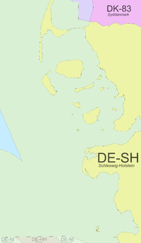
Map and stats
| Name | code | area type | country | Geohash probability |
|---|---|---|---|---|
| ■ Schleswig-Holstein | DE-SH | land | Germany | 22.8% |
| ■ Region Syddanmark | DK-83 | land | Denmark | 3.5% |
| ■ Schleswig-Holstein | DE-SH | incl. waters | Germany | 93.0% |
| ■ Region Syddanmark | DK-83 | incl. waters | Denmark | 3.5% |
| ■ Hamburg | DE-HH | waters | Germany | 0.75% |
| ■ Niedersachsen | DE-NI | waters | Germany | 0.74% |
Local Geohashers
None, yet.
Attendance plans
<none>
Past Expeditons
- 2023-08-24 54 8 in a forest in Bredstedt, by Fippe
- 2014-08-19 54 8 on a meadow between Husum and St. Peter-Ording, by TheOneRing
- 2014-04-11 54 8 on a field near Neuenkirchen, by Rincewind and Yakamoz
- 2012-06-07 54 8 Koryu tries to reach a geohash in the tidelands during an ebb. Didn't attempt because of bad planning.
- 2009-06-26 54 8 in a grazing meadow northeast of Højer (in Denmark), where dawidi went from Kiel by train and bike (via Klanxbüll) in the afternoon.
- 2009-06-24 54 8 in a graveyard in Enge-Sande, north of Husum, where dawidi went from Kiel by train and bike in the later afternoon.
