2008-05-26 41 -71
| Mon 26 May 2008 in 41,-71: 41.6731281, -71.6073080 geohashing.info google osm bing/os kml crox |
Contents
[hide]About
41.673128°, -71.607309°
The coordinates in the Providence graticule are in Coventry a few meters into Big River, a fairly popular spot for boating and easy to see from the nearby bridge.
The Journey
Just a small town girl... wait, wrong journey.
Patrick arrived first, independently, taking a few shots of the coordinates from the aforementioned bridge, shortly after being met by Yusuke's "Are you the one they call Patrick?" Yusuke, Yusuke's Ride, The Nihilist, and Shannon arrived slightly late due to Memorial Day traffic and a stop at Benny's to pick up snacks, a raft, a pump for the raft, and a crowbar for raptor protection. Patrick led the way, having already somewhat explored the area. A path over a hill with noticeably lacking grip led almost directly to the nearest land location to the actual spot.
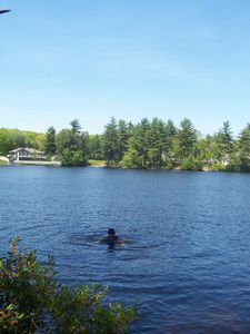
Despite the lack of proper tools to inflate the raft, Yusuke's Ride and The Nihilist volunteered to attempt the water geohash. The Nihilist went first, and Yusuke's Ride felt the need to one-up him, explaining his lack of shirt. The latter lost his sandal in the water, so science (a big stick) was employed to retrieve it. Then science was also lost in the water, so pseudo-science (a smaller-but-still-quite-large stick) was used to retrieve it. Pictures were of course taken at every turn.
Much fun was had with the local boaters. Some of them will have stories to tell for a long time.
Before leaving, we decided to leave a geocache of geocash, hung on science hung on The Root of All Science (the tree which marked the location on the satellite ). The status of the geocash as of Thursday, May 29 is unconfirmed.

The Answer
In early July, Yusuke attempted a return to the coordinates on foot to check the status of the geocash and the location in general, with moderate success.
The walking distance to the location was severely underestimated. What took 10 minutes by car took two hours one way. Ordinarily this would not be a problem for Yusuke... but this was July. Despite leaving fairly early in the day, the unanticipated distance and extra time involved assured the sun would rise higher in the sky than he had hoped. It was a long, exhausting day that could only end happily with a cold shower (which it did, thank goodness)
Upon arriving at the coordinates, Yusuke discovered that the site was mostly unchanged (the same Pepsi can and underwear from the May adventure lay undisturbed), with the exception of two things. First, the geohash sign was missing, meaning one of two things. Eiter that someone had successfully discovered the booty and plundered it, or that the sign had fallen into the river. Given that science didn't seem to have been touched at all, Yusuke determined it was likely the second scenario, and was saddened.
But then Yusuke noticed a second thing he did not remember: a second sign! This one was all official and stuff too. It was only visible from the river, so Yusuke took the plunge to read it. He was surprised to see it read "Please Do Not Litter Our Pond --The City of Coventry." Was that there before? Did the greedy city government in Coventry come to collect a geohashing tax and put the sign up as a cover?
The world may never know.
Quotes
To boaters:
- "Hi, we're from the internet!"
- "Would you like to join us for punch and pie? ...And by that I mean beef jerky and Coke."
- while waving crowbar menacingly "We're harmless!"
- "Move under the branch, you'll be a winner."
To ourselves:
- "You may have missed it, but we have officially entered the realm of raptor slash porn."
- "Red spiders!"
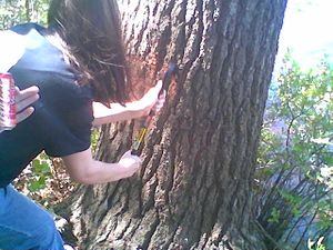
- "...What is she doing to the tree?"
- Several puns too shameful to list.
Pictures
- Pictures
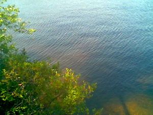
The (rough) coordinates from the bank of the river.
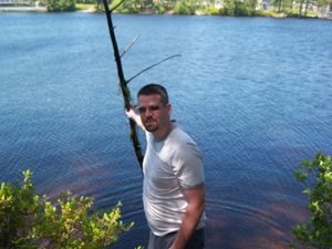
The Nihilist under the great tree that was our spot
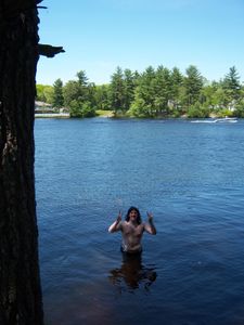
Yusuke's Ride gets wet (or, the water attempts to get a ride)
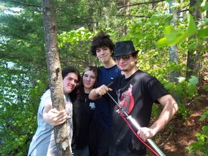
4/5 of the geohashers: Yusuke's Ride, Shannon, Yusuke, and the Nihilist
Patrick, with science
Shannon shows us how to properly defend against a raptor using our defense mechanism (a crowbar).
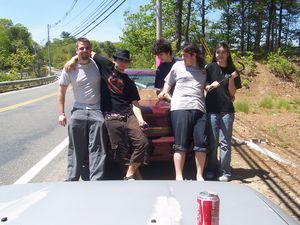
The entire expedition around the great Patrick's car. The can of punch in the foreground is on Yusuke's Ride's car.
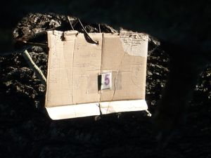
geo-"cash", possibly still available at the site! Text reads: "First Providence Geocash, Eeee!" with signatures on the left and "VICTORY!" on the right.


Achievements
5 geohashers earned the Graticule Unlocked Achievement
|