2008-10-16 59 -122
| Thu 16 Oct 2008 in 59,-122: 59.0481304, -122.8507823 geohashing.info google osm bing/os kml crox |
Location
At an unremarkable location within a graticule that is largely forest, broken by seismic lines and dirt access roads.
Participants
Robyn and the airplane she flies for work. (And someone else who wasn't told he was geohashing)
Expedition
This is a somewhat odd expedition as I have been assigned to overfly the ENTIRE graticule (and part of the next one over), with east-west lines spaced 500 m apart. That's right: I am to fly back and forth, back and forth 70 km per line, all the way from the 59th to the 60th parallel. When I am done, I there will be no point in the graticule of which I have not been within 250 metres. There must be easier ways to get a Déjà Vu Geohash achievement than preemptively hashing every point in the entire graticule, but I've never gone for the easy way.
The criterion for an air hash is to be within 10 arc seconds of the geohash. As my lines are east-west, my distance from a geohash will always be north-south, a direction for which one minute of latitude is equivalent to one nautical mile, or 6000 feet. If sixty seconds of latitude is six thousand feet, ten seconds of latitude is one thousand feet, or about 300 metres. Any day that the geohash falls in the section where I am flying lines is a day that I cannot fail to achieve the geohash, unless I screw up my job.
Today the geohash fell near the southern edge of the graticule. We started in the south and after four or five hours we flew right by it. There is no picture of the view, because by the time we got there it was night, and the north is very very dark at night. There is nothing outside to photograph.
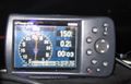
The unmissable geohash

Robyn earned the Air geohash achievement
|