2008-10-18 49 12

| Sat 18 Oct 2008 in 49,12: 49.0236881, 12.3062578 geohashing.info google osm bing/os kml crox |
On a hill above Bach an der Donau, 15km east of Regensburg. The exact spot was in a forest without any discernable trails. Tomcat and dawidi independently planned to go there, with Tomcat aiming to arrive by car at 9:00.
dawidi
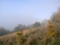
As usual, I overslept and hit the road nearly an hour later than planned, at 8:00 in the morning. I cycled through the cold and dense autumn morning fog at my maximum sustainable speed, the GPS telling me that I might just make it in time to see Tomcat drive off. In Schwabelweis (about half the way) the fog cleared and I was greeted by warming sunlight, even though the air was still cold. Passing by last Tuesday's hashpoint in Sulzbach, I re-entered the fog that was still lurking on the Scheuchenberg's southern side. Approaching Demling, it became so thick that I was startled several times by large trees suddenly jumping out of the gray curtain.
I arrived in Bach at 9:07 and met Tomcat and his drag-along Hans, standing at a bus stop and discussing how to get to the hash. We decided to try a small road with the promising name Bergweg. The footpath shown in our maps that was supposed to lead from there to the hash did not exist. There was a very steep and narrow meadow that might have been the footpath a few decades ago, but it seemed to end at a gate between some vineyards. Hans decided to ask a man in one of the houses to which the meadow seemed to belong, and he gave us permission to open the gate to get to the forest beyond it. He assumed we were on an orienteering hike and we happily left it at that.
We navigated to the coordinates, wading through the wet grass, through some shrubbery and into the woods. Reception at the hash was suboptimal, but we narrowed it down to 10m or so. We took the usual pictures and I marked a smooth-barked tree with some chalk. Not that I expect anyone to pass by that tree before the next rain, but it was fun.
Tomcat and Hans then went back down to continue on their day's trip. I stood on the hillside for nearly another hour, waiting for the fog to dissipate and reveal what I expected to be a great view of the Danube plains and Scheuchenberg, but it only allowed me a glimpse of some of the trees on the edge of Scheuchenberg, then closed up again. So I went down as well.
I didn't want to just take the same way back again, so I rode north to Kittenrain (now that's an entry I have to put on my "Bavarian place names explained in English" list) and then to the west through the valley "behind" Scheuchenberg. It was an unpaved, "30kph max" road, but ok as a cycleway, and with the sun finally having won against the fog, provided an annoyingly large number of photo occassions with beautiful, almost alpine views of rolling hills covered in colorful autumn trees. After passing by a golf club at Parkhaus (not a car parking building, but "the house in the park", apparently), I joined the Danube cycleway again in Sulzbach and went home normally from there.
Photos
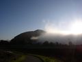
The fog persisting on the sunny side of Scheuchenberg seems to be a frequently occuring weather phenomenon.

Within accuracy range.
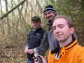
Hans, Tomcat and dawidi.
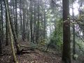
At the hash - just some forest.
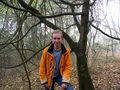
The writing's on the... tree.
Not a view of Scheuchenberg.
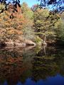
Small pond on the way from Kittenrain to Sulzbach.
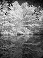
Same in monochrome infrared.
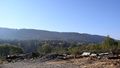
North face of Scheuchenberg, from Parkhaus.
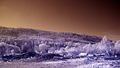
Same in 2-channel infrared.


