2009-02-20 30 -94
| Fri 20 Feb 2009 in Beaumont, Texas: 30.9538681, -94.0724407 geohashing.info google osm bing/os kml crox |
Contents
[hide]Planning
I'm in the northwest corner of the Lake Charles, Louisiana graticule with only feet for transportation, and expected to have the day off, so I called upon the geohashing gods for a corner geohash, and they delivered. Not in Lake Charles, but in the adjacent Beaumont, Texas graticule, making it an eight mile (Google Maps gives answers in miles when I'm in the US no matter what I tell it my home preferences are) walk. It looked quite close to what looked like a powerline right-of-way, and there's usually a good path along a powerline, so I expected to be able to reach it. The route I chose would also take me past the only bike shop in town, so I planned to stop by and see if I could rent a bicycle for my mission. If not, it would be about a two hour walk, plus let's allow an extra hour because that last kilometre to the geohash can be a killer.
What do you think can go wrong here?
Expedition One
I did my morning tasks and packed my geohashing knapsack, plotting my route, knowing I have six hours left before dark. While I was studying the access routes, my telephone rang.
The good news: "Would you like to borrow a truck ..."
The bad news: "...to get some lunch before work at two-thirty?"
So much for my free day. I thought the airplane would not be arriving back until tonight, but it's expected now at two-thirty. I take the truck. And my geohashing knapsack. I drive up the road in the direction of the geohash, and then with strength and responsibility I park the truck in front of the restaurant and go for lunch. During lunch I turned on my GPS and looked. Eight kilometres as the crow flies. Eight miles by road. How long does it take to drive eight miles? I finished lunch at one o' clock. I walked back to the truck. Left down Main Street leads back to the hotel. Right on Main Street leads to the geohash. I turn right.
I go up Main Street, and right on Martin Luther King. I'm supposed to turn left on Armstrong Lane. MLK goes up and down a few hills and I pass a broad powerline right of way, that's probably the same one the geohash is near. It's awesome, a hard dirt road with a locked vehicle gate but easily walkable. Let me just get to the access from Armstrong Lane. And then MLK does something weird. It ends. It ends in almost a dead end. It's actually a fork, with a dirt road going each way. I turn left, and then things start to look good. The road winds back and forth. There are no "No Trespassing" signs on the sides. There's one sign that says "POSTED" but nothing else. Is that like "First post!" in a forum thread?
I reach a point under 600 metres from the geohash. I drive a bit further and the geohash recedes, and then the road turns away. I turn around (four or five point turn in the borrowed truck on the one-lane road). There are even some paths leading into the bush. It's 1:20. The bush does not look like Slave Lake bush. Surely I can go 580 metres and back in time to return for work at 2:30. I step off the road and into the bush. It's firm underfoot and easy going. I can totally do this. The trees get a bit thicker.
"Robyn!" I explain to myself, "Do you not remember Utikuma Lake?" Five hundred metres through the bush can take over an hour. I check my cellphone. No signal. Sadly, and responsibly, I walk back to the truck. I don't even try the little trails that might have led near the geohash. No time. I drive away. I know I'll regret this later.
I get back to work with the truck at two. The airplane is early. It's here already. It's a good thing I was responsible.
Expedition Two
So I go to work. On the ground while waiting for someone I program the geohash into the airplane GPS. Hmm. Eight kilometres as the crow flies is also eight kilometres as the airplane flies. Very very close to where I am. And the track lines on the GPS show that I've flown right through the point on previous trips to the same destination. It's time one again for Robyn's Airhash Consolation Prize. This time I set up the GPS to display UTC time and coordinates, and I have time to name the point with an X for xkcd.
After takeoff, nothing unexpected happens. I take pictures out the window of the geohash. I'm not positive where the point is in that picture. It was taken at a lower altitude while still approaching the point. I think it is looking north. I take pictures of the GPS and hope they work out.
I crossed the point again on the way back home in the dark, but was busy and took no pictures.
Expedition Three
I land at nine p.m. That leaves three hours in which I could geohash. I could borrow a truck for dinner. I could actually get dinner, and then I could drive back to the access point and actually get there. I could have a midnight double virgin geohash!
"Robyn! Do you not learn?" Remember last time you tried to go 600 m into the woods in the dark. And that was in agricultural land. Without alligators.
Robyn learns. Robyn goes to bed hoping that the airhash photos worked out, within the specified 10 seconds of latitude and longitude, and does not embark on expedition three. But in her head, it was glorious.
Photo Gallery
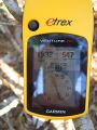
With 547 m to go, Robyn succeeded at being responsible.

Despite the failed geohash, Robyn managed to grin.
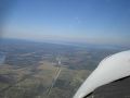
There's the geohash again, from a different angle.
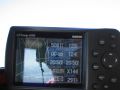
And this time I nailed it, within 0.3 seconds of the latitude and under 2 seconds of longitude.


Achievements
Robyn earned the Graticule Unlocked Achievement
|