2009-02-28 40 -74
| Sat 28 Feb 2009 in Hightstown, NJ: 40.2382246, -74.4560588 geohashing.info google osm bing/os kml crox |
Narrative
10:30AM : This geohash is still tentative. I was ill during the week, especially last night, but we still have all our notes for planning the trip, so we may do it anyway.
I posted to the FB group that I was going. It looks like a great site for a meetup, but I don't think anyone pays attention to the group.
3:00PM : After a not-so-quick stop for grocery shopping in the Brunswicks, we started to head down to the geohash. It was a nice clear day, but pretty cold, but the geohash looked like it would be in an open space that was easy to reach. There was some kind of marker / roadway / message to aliens in the area, so the exact point was readily identified, even without a GPS.
Hightstown, it turns out, is at the northern reaches of the Pine Barrens, a mysterious, swampy place where people live anyway. It hadn't been particularly rainy lately, but many places in the woods had brackish black pools of mud. On one road, we saw two geese huddling in such a puddle. Gwynnath told me that often one goose will stay with a wounded comrade when the other cannot fly, to protect it from predators. Not sure how that works out, since geese don't usually carry weapons, even in NJ, but any plan is better than no plan at all.
Speaking of planning, before leaving, I had printed out directions from Google Maps, so of course we missed a turn and ended up off track. The directions didn't warn us that N Disbrow Hill Road would meet Disbrow Hill Road (no "N"), so I counted that as a "turn".
Once we realized we were off the route, I stopped on the south banks of Lake Etra, and checked Google Maps (mindless faith in technology!!) while Gwynnath took Evan for a walk by the lake. As luck would have it, we were on the road we were looking for, it was just called something different here, and we had been going in exactly the wrong direction. (Good thing we stopped where we did!)
Heading back, as we took a turn down Battlefield Rd., I said, "Who needs maps anyway?" To which replied Evan, "We do!" Smart kid, him.
When we finally get to the field, it turns out not to be a park (hadn't really expected it to be), but a low-lying field with a culvert for drainage (hadn't expected that either). After parking on the side of Perrineville Rd., we walked downhill around a line of pine trees, and saw a big, gaudy red ribbon sitting in the field. I cried out, "Holy cow, someone got here before us?" Except the ribbon wasn't very close to the hashpoint, maybe 20-30 meters away, so we wrote it off as lost Christmas decor that had ended up here.
We would have picked it up, if not for the vast, ubiquitous deposits of poop in the field. The local fauna apparently has learned that they would not be disturbed if they relieved themselves in this field, as opposed to the rather nice lawns of the neighboring community.
The strange alien markings in the field turned out to be concrete gullies at the lowest points of the field, leading to a sewer culvert. Oh, and did I mention the poop? We decided not to linger, and the stiff cold wind convinced us not to expect any other geohashers that day.
Gallery
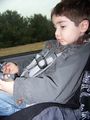
Evan practices his ARRRRGH!

Avast me hearties!
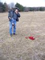
Methinks someone got to the treasure a'fore we did.
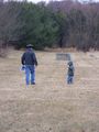
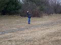
I count off the steps to the geohash.
I consult me map.
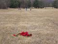
Yaaaar! This be the spot!

Evan! Start digging! ... Evan? Wh'ar did ye go?
Gwynnath isn't digging either.

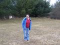
She can at least give us a smile.

Evan scowls and brandishes his hook-hand.
Maybe the treasure is buried thar?
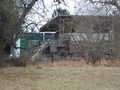
Nearby apartments. These scalawags have no idea how much treasure be buried out thar!


Ribbons
- Land geohash (repeat)
- No batteries (repeat)
Jevanyn earned the Buccaneer Geohash Achievement
|
This user has visited an Easy Geohash
|