2009-02-28 52 0
| Sat 28 Feb 2009 in Cambridge: 52.2382246, 0.4560588 geohashing.info google osm bing/os kml crox |
Contents
[hide]Location
Only a few metres off a public footpath, in a fenced horses' field which is the private property of the Longholes Stud Farm, a little east of Newmarket.
Participants
Expeditions
Benjw
While looking up the weekend's coordinates yesterday, I saw that this one was (a) not very far away, and (b) possibly accessible. Hurrah! A chance for my first Saturday meetup. I didn't suppose that there would actually be anyone to meet up with, though, but nevertheless I put an expedition planning page up on the wiki. Saturday dawned, and I went to work for the morning. And what a pleasant surprise it was to get home and find that there was someone interested in going! Thanks, Stephen, you've made my day!
Now, I was intending to cycle to this one. Honest. But after being at work all morning I just wasn't up to it. I do quite a lot of cycling each year, but I tend to be a bit of a fair-weather cyclist and most of it's in the summer, so I'm a bit out of practice, and I didn't think that a 50-60km round trip after a morning at work was such a good idea after all. Next time, maybe.
So I drove. The nearest road access was about half a mile from the hashpoint, where I found the public footpath sign and set off to walk the rest. The footpath went through a stud farm, but there didn't seem to be anyone about. It then passed briefly through some woodland and then ran along a track beside the edges of the fields.
At 15:58 I was 17m from the hashpoint, but this was as close as I could get for now. There were five horses in the field, and they all seemed very friendly -- they came up to the fence to sniff my hands and chew my coat. I hung around with them for a bit.
About five minutes later, Stephen Turner turned up. We chatted for a bit, and just as we were trying to decide whether it was worth going all the way over to the farm buildings to ask permission to enter the field, a Land Rover came along the track. We flagged it down, but the driver turned out to be stopping anyway, to feed the horses. He was curious to know why we wanted to walk 50 feet out into his field and then walk back again, so we explained about geohashing. He probably thought we were a bit odd, but since we didn't want to do anything except stand there, he agreed that we could. Result.
While he got on with feeding the horses, we found the hashpoint. Our two GPS receivers disagreed by about two metres as to the exact spot, but we both got the coordinates to full accuracy, and two metres is well within tolerance. Photos were taken, and we walked back. After a bit more chatting, we bid cheerio to horse-feeding-guy and to each other, as the footpath back to my car was not the easiest way to leave on a bike.
On the way home I found a couple of geocaches as well, so I am "well chuffed" (to use the vernacular) with today's expedition. It was good to finally make a Saturday meetup, and fantastic to actually meet someone there. I feel elated, I really do.
Stephen Turner
I did this one on the way back from doing two geocaches. Nothing to add to what Ben said, except three photos.
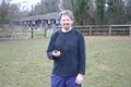
Stephen Turner at the point
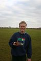
Benjw at the point
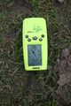
The evidence


Shiny ribbons
Wow, lots!
Stephen Turner and Benjw earned the Land geohash achievement
|
Stephen Turner earned the Bicycle geohash achievement
|
Benjw earned the xkcd Nullaturion achievement
|
Benjw and Stephen Turner earned the Ambassador achievement
|
Benjw and Stephen Turner earned the Meet-up achievement
|
Benjw earned the Earliest geohasher achievement
|