2009-03-16 52 0
| Mon 16 Mar 2009 in Cambridge: 52.2662005, 0.5046215 geohashing.info google osm bing/os kml crox |
Contents
[hide]Location
Another Field Geohash, this time on a farm in Kentford, just northeast of Newmarket.
Participants
Planning
I'd recently been told that geohashing is much more fun when you don't do it all by car. And since this one was within reach of a railway station, why not go by train? It's a mile and a half from Kennett station, which has direct trains from Cambridge, albeit only every two hours.
Timing is tight, though. Trains to this station are a on a shuttle service between Cambridge and Ipswich, and only run every two hours. The 12:43 train from Cambridge was timetabled to arrive at Kennett at 13:11. That would give me 55 minutes to walk the mile and a half to the hashpoint, find it, take photos and walk back again, in order to catch the 14:06 train back to Cambridge. Certainly possible, but without any time to waste.
Expedition
Benjw
Well, I have to say: Robyn was right. This was a lot more fun. It had all the "will-I-make-it-in-time?" excitement that a train timetable creates, as well the usual fun of finding the exact spot. I am henceforth converted to the cause of Public Transport Geohashing, and will endeavour to do so whenever possible. (When I get round to fixing my bike I'll try that, too.)
Back to the expedition: the first bit all went smoothly, anyway. It was a lovely sunny day, and I walked from home to Cambridge station, bought my ticket and found my train -- a cute little one-carriage jobbie. Obviously not many people use this line. The journey took just under half an hour, with an intermediate stop at Newmarket, and I was the only person to get off at Kennett, a tiny little station which seemed to be in the middle of nowhere.
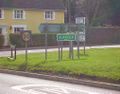
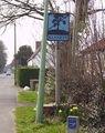
No time to look around, though -- the clock was ticking. The road was easy to find as it crossed the railway on a bridge. I walked quickly, but decided not to jog. That way, however long my outward journey took, I knew I could get back to the station in less time. I walked past several houses with neat front gardens, then crossed the Cambridgeshire-Suffolk border at a road junction. Soon I had left Kennett village and entered Kentford, and there I took a right-turn onto an attractive country lane. No pavement here, so I walked on the road, but I passed only one car, so it wasn't exactly busy.
While walking down this road I entered the hash coordinates into my GPSr -- which then told me I had over 200km to go. It took me a while to realised that I'd pressed "up" instead of "down" when changing yesterday's 51 degrees North into today's 52 degrees (well, 2 is "up" from 1, isn't it?), so it had ended up as 50 degrees and was trying to direct me to a point in the English Channel. Oops.
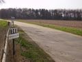
By the time I'd sorted that out I had only 200m to go to the hashpoint. I turned off the road onto a concrete track leading to a farm; the hashpoint was in the adjacent field. The walk had taken me almost exactly 20 minutes.
The field to one side of the track was full of new green shoots, but on the other side -- my side -- it was bare earth, so I could find the exact point without trampling anything. I did so, and photos were taken. By then it was 13:35 and I had half an hour to retrace my steps to the station. The terrain was level, so it wouldn't take me any longer to walk back. I relaxed a bit!
On the way back I paused by a pub to re-tie my shoelace. I considered having a geopint -- I had enough time (just) but at 700m from the hashpoint (850m by road), it was well out of sight and wouldn't have got me a ribbon anyway. I settled for a bottle of apple squash that I'd brought with me, and carried on.
I got back to the station with eight minutes to spare before my train, and of course when it eventually turned up it was five minutes late. Typical. This time it was a luxurious two-carriage conveyance, and I proceeded to Cambridge in style, with a maximum speed, I noted, of 105km/h. During the journey, I read some of a textbook on Newtonian mechanics. Try doing that while driving a car. Then I had just over a mile to walk home, and arrived almost exactly at 3pm, two hours and forty minutes after setting out.
Total distances travelled today: 63.6km by train, 8.4km on foot.
Shiny ribbons earned
Benjw earned the Land geohash achievement
|
Benjw earned the Public transport geohash achievement
|
Benjw earned the Consecutive geohash achievement
|
Photographic documentation
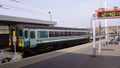
Sir, your carriage awaits.
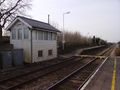
Tiny station to match the tiny train.
Crossing the border.
An attractive double-sided village sign.
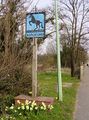
The other side of the village sign.
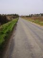
Sunny English country lane.
Here be the hashpoint.
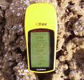
Proof of hash.
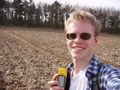
Happy geohasher (à la Arvid, but without the beard).
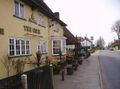
Tempting, but would have meant a 2-hour wait for the next train.


