2009-04-24 52 0
| Fri 24 Apr 2009 in Cambridge: 52.1548551, 0.1314059 geohashing.info google osm bing/os kml crox |
Following on from yesterday's hashpoint on Wort's Causeway, today's was only marginally further from Cambridge -- in the garden of a bungalow on More's Meadow, Great Shelford.
Expedition (Benjw)
Today's hashpoint was very close to Cambridge, where I live, so I had planned to get home from work at lunchtime, then walk to the hash and back during the afternoon. Instead, I got home from work... and fell asleep. I woke up at about 4pm, and decided to cycle instead.
By the time I left the house at 4:47pm, rush hour had started, so progress was slow through the traffic in Cambridge. Once I got through the town centre, though, things got better as I got a cycle lane to ride in. Between Cambridge and Trumpington I had a significantly faster average speed than the cars. In Trumpington I turned left and cycled into a gusty headwind the short distance to Great Shelford. I arrived at More's Meadow, a residential cul-de-sac, at 5:06pm, having cycled 6.87 km.
My GPSr was zeroing in on a point in the back garden of one of the houses, but it was close enough to the road that I was (just) inside the magical 3m circle standing outside the fence. That would probably count as hashpoint reached, then, but I wanted to get to the exact spot if I could.
I entered the garden and went up the side of the house to the front door, which was standing open. I knocked and a dog -- some kind of retriever -- came to stand on the doormat and bark at me. The owner of the house, a middle-aged lady, followed. I asked if I could photograph her garden and explained that I was on a kind of treasure hunt to a set of random coordinates. She agreed that I could take photos (I also checked that it would be all right to stand on her lawn to do so, although given what the dog then did to the lawn, me standing on it was probably nothing to worry about).
I got the GPS reading to within a metre between some pot plants and the garden border, took a couple of quick photos, thanked the kind lady and departed.
I decided to take a different way home, partly to see if it was any shorter, partly because it would involve a nice cycle path which is painted with coloured stripes representing a DNA sequence (it also has a DNA 'sculpture' at each end, which is kind of fun), and partly because it would take me past my girlfriend's workplace. However, when I got there I found that she'd already left, so I headed home.
The route back, along the cycle path to Addenbrooke's Hospital and then along Hills Road back into Cambridge, was 7.5 km, giving a total distance for this expedition of 14.4 km. I got home at 5:40pm.
Photographic documentation
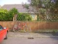
Hashpoint 3m that way.
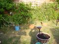
Inside the garden.
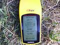
Proof of hash.
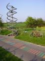
DNA enlarged 75,000,000 times, marking this rather good cycle path.
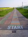
10,257 stripes representing the BRCA2 gene sequence.
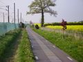
Good use of space -- between the field and the railway.
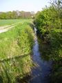
Hobson's Brook, named after Thomas Hobson who coined "Hobson's Choice" in the 16th C.
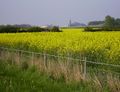
Across the fields to Addenbrooke's Hospital, Cambridge.
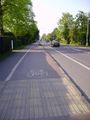
Cycle lanes on the road into Cambridge.
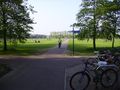
Cycle and pedestrian paths through a park.


Shiny ribbons earned
Benjw earned the Land geohash achievement
|
Benjw earned the Bicycle geohash achievement
|
Benjw earned the Consecutive geohash achievement
|
Benjw earned the Ambassador achievement
|