2009-04-25 48 8
| Sat 25 Apr 2009 in Pforzheim: 48.4809778, 8.3527699 geohashing.info google osm bing/os kml crox |
Contents
[hide]Location
The hash in the Black Forest, somewhere in the middle of nowhere on a mountain near Baiersbronn.
It's actually the first expedition that goes into the Black Forest, all earlier ones in this area were somewhere outside or at the very margin of the mountains.
Participants
Expedition
Getting to Freudenstadt: Ekorren
It was either this hash or the one in 48,9. Both of them seemed to be accessible, both wouldn't be too boring. I had almost decided for the other one when Koepfel announced that he would also attend this one. We agreed to shift the meetup time to 14:00, announced that on the graticule page and went on with our planning.
It was too far to go there all by bike, more so as it is a mountainous area and following the valleys means huge detours. On the other hand, I could have taken a train from Tübingen all the way to Freudenstadt, but that one would be too expensive. There is a way to get there for a good price, though: Go by bike to Rottenburg first, which is only about 11 km from my home, on an all-tarnac low-slopes route, and where the train would leave at 10:15. So I went for that, and started around 9:30.
I was faster than usual on that route, and arrived at the station in good time at 10:00. Boarded the train and went for Horb. Usually, to get to Freudenstadt you stay on that train until Hochdorf and change there to a train from Eutingen. But on a sunny spring saturday like this, there might be a problem: There are sometimes large groups with bikes coming from Stuttgart, and as the train to Freudenstadt is a bit low on bike space, it usually is a good idea to be on the train before they arrive, to make sure you get a place. Which is possible by a small trick: just take the train to Stuttgart until Eutingen and enter the train to Freudenstadt there.
So I did. It was crazy. There were incredible amounts of incredibly stupid and partly already incredibly drunk human beings, going to Stuttgart to watch an incredibly boring game called soccer. There was place enough in the compartments, there were free seats in the upper deck, but instead of finding themselves some space, they huddled together in the entrance rooms, blocking the doors, making it difficult to enter or leave the train. Which probably was why the train was late, but it wasn't late too much anyway, so it would still arrive at Eutingen before the train from Stuttgart would be there.
Somehow I squeezed myself and the bike into one of those overoccupied entrance rooms, trying not to step on an empty bottle or make any honest remarks. When people asked whether I had a bomb in the box on my luggage holder, I confessed and asked them to take it to the stadium because it would be much more efficient to blow it up there than in the Black Forest. They refused and almost went into panic. Too bad they finally did not flee the car. A little more space would have been quite a plus.
I was glad this was only a ten minutes trip, and, arriving at Eutingen, I found that all my doubts about enough space on the train to Freudenstadt had been unnecessary - the connecting train from Stuttgart was half an hour late so ours went off empty, as most of its passengers were still stuck somewhere half way.
At noon, and 738 m above sea level, the train reached Freudenstadt city station where it met a train from Karlsruhe, which Koepfel had taken to get here.
Getting to Freudenstadt: Koepfel
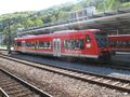
I left my home at about 9:30 and cycled to the Main Station, buying some food on the way for the long train ride I was about to begin. At the Main Station, I brought my connecting ticket, since my KVV-monthly-ticket was only valid to Forbach. This is actually my first expedition, that required me to buy a ticket, as all previous expeditions were covered by my monthly ticket. Here's a photo of my train, the S41, planned to leave at 10:18. Normally, the S41, starts in Karlsruhe Marktplatz (Market Square), goes to the Main Station as a tram and then changes to train voltage, but due to construction works between Karlsruhe and Rastatt, it terminated here.
The S41 runs from Karlsruhe via the spectacular Murgtal line to Freudenstadt and continuing to Eutingen im Gäu. The ride from Karlsruhe to Freudenstadt took about 1h and 40mins and was about 78 kilometers long. This photo was taken out of the train, the Hashpoint should be somewhere in these mountains.
At noon, I arrived in Freudenstadt Stadtbahnhof, where I met Ekorren.
From Freudenstadt to the hash and down to Schönmünzach
It was no problem finding another on the platform as all other passengers from Karlsruhe already left the platform and Koepfel was the only one still waiting, so we were the only two passengers with bikes. We went for a short side trip into town, and Ekorren needed to buy some food and drinks.
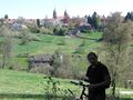
Freudenstadt is a planned city that almost looks like a game board of Nine Men's Morris. Unlike almost all other towns in Europe, it hasn't grown from a village, or a medieval town, or any other historic site but was built as a whole at the beginning of the 17th century, as a new side residence for the Duke of Württemberg. It features a market square that is actually really a square and is said to be the largest of Germany. All this on a rather small area on a hilltop, or rather a ridge, in the middle of the Black Forest.
So we took a short visit to the market place and then went on for our quest. There was a side valley we had to cross, and a small castle we saw but didn't realize that that building really was the castle, and then we needed to go up on a mountain.
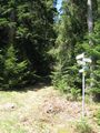
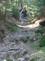
The bad thing was: No map that we had available, including the official 1:50.000 topographic map, showed any decent way up from this side of the mountain. The choice was to either take a huge detour of several kilometres, or try and find some forest track up which wasn't shown on the maps. Since this was only for a short distance, we went for version 2, and part pushed, part carried our bikes over a hiking trail up. It wasn't easy, but not as bad as it could have gone.
Then we made our way over good forest tracks in the direction of the hash, until we came to an intersection where two things waited for us: some leftover snow, and a total stranger who wasn't really decided what to do next.
This wasn't the hashpoint, but the chance to build yet another snowman, months into spring, at a temperature of about +20°C - that couldn't be missed. So we did, see the gallery below. About the stranger... well, we talked a bit, and revealed our plans, that we wanted to visit that arbitrary point, and then look for the old wolf pit that was on the map, and then go down to the Sankenbach falls and lake. And since he didn't have any other goal, he decided to join us. Drag-along achievement!
Now, there was a small problem. We believed to know at which intersection we just had arrived, but somehow that looked quite different on the map than in reality... until we found out that we just had been going another track for several kilometers than we had believed! Luckily, that was only a parallel track, and we just were a few hundred metres from the expected place at the next intersection, so after realizing where we actually were, it was easy to continue. We came near the hash, and at the point where the GPS pointed at 90° into the forest, we parked the bikes and climbed down through the underwoods.
14:00 - coordinates reached. Exactly in time for the fixed meetup time. As expected, noone else had made the way, so we took pictures, left our marker, and went on the search for the wolf pit.
We weren't really sure what to expect, but we are sure that we didn't find anything. Again, we stumbled through dense underwoods, balanced over logs, climbed on stumps to get a view, although there actually would have been an easy way back to the bikes from the hash (which we just hadn't discovered on our way to the hash)... and finally, gave up. Went back to the bikes, parted from our drag-along and went for the downhill part of the journey.
The map showed a lake and a waterfall worth seeing along one of the tracks leading down into the village from here, so we took that route. And it actually was worth seeing, see the pictures. It also was a nice romantic valley from there down to the town of Baiersbronn, which we, after a detour for a geocache, reached around 16:15.
As there was no hurry, we decided to ride on further down the famous Murg valley. On the way, Ekorren stopped at two yellow phone booths, which he needed for a bookcrossing challenge. We also discussed, why the marked bikeway sends bikers over steep hills, while the car road on the other side of the valley is completely flat. At Schönmünzach, we split up. Ekorren entered his train back to Freudenstadt and from there back home, while Koepfel continued cycling down the valley to Raumünzach, from where he took the next S41 back to Karlsruhe.
Gallery
Train from Tübingen to Horb
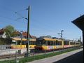
Both of the trains we arrived with at Freudenstadt Stadtbahnhof
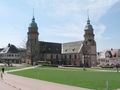
Main church of Freudenstadt
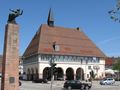
Old town hall
We had to cross this valley
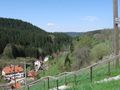
A view back on Freudenstadt
Not a decent cycle trail, but a shortcut.
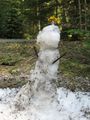
There was snow!
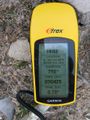
Coordinates reached
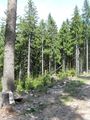
Hash path. We took the hard way, anyway.
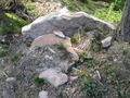
The hash point is stone(d).
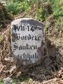
Just an old marker on the way
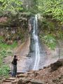
Sankenbach waterfall
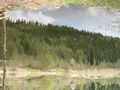
Sankenbach lake
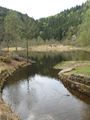
Sankenbach lake


For those, who want to see even more photos, Koepfel's photos can be seen in this gallery.
Koepfel and Ekorren earned the Drag-along achievement
|
Koepfe and Ekorren earned the Meet-up achievement
|
Koepfel earned the Consecutive geohash achievement
|