2009-05-02 48 -122
| Sat 2 May 2009 in 48,-122: 48.9585510, -122.0748822 geohashing.info google osm bing/os kml crox |
The point is just by the side of Silver Lake Road, less than a kilometre from Silver Lake Park which has a campground.
Contents
Planning
We really wanted to climb Garibaldi Mountain for the Vancouver are but there's still too much snow in the area, and this one is less than a hundred metres from Silver Lake Park, to allow us to get the Camping geohash. The location allows driving, cycling or part transit/part cycling.
Detailed planning on Talk:2009-05-02 48 -122.
Participants
Expedition
Robyn
I was going to do this as a pure bicycle geohash, riding the entirety of the 110 km from my house to Silver lake Park, but I was rendezvousing with Rhonda at a fairly arbitrary point along my route, and stressing about being late to the meetup or about being overtired by the end of the day and unable to carry my camping gear up the last hills to the campground. The terrain view in Google Maps did not show an elevation change at the end, but it is possible for there to be significant hills without countour lines in undulating terrain. And this lake is in the foothills of the Cascade Range. I elected to take the SkyTrain past the most tiring of the city traffic and over the Fraser River. That cut about 15 kilometres off my route.

Leaving transit I crossed under the SkyTrain tracks and coasted down King George, following the route I had plotted through the Fraser Valley, avoiding the nastiest hills and working my way towards the Sumas border crossing. I turned left on highway 10, then down 152nd Street to 32nd Avenue, turning right at 192nd, left on 28th, right on 208th, and then left on 16th all the way to 264th. My planning worked even better than I expected, and I can't remember meeting any especially long or especially steep hills. I reached the corner of 264th Street and 16th Avenue after having ridden sixty kilometres in under three hours, and with plenty of energy to spare for the rest of the trip. My efficient route did get me to the corner forty-five minutes ahead of the agreed meeting time, but Rhonda is almost always early, so I probably wouldn't have to wait more than thirty minutes. Meanwhile I could sit down for a bit, program my GPS properly, sort out my maps, and have a snack.
I did all those things and also made a flower chain necklace out of roadside dandelions, for T-Rex, but still there was no Rhonda. I couldn't see her coming down the road, either so she wasn't almost here. It's not like she's late for failing being fifteen minutes early. In fact I started to be very impressed with her timing abilities. It's hard to travel a long way and be there exactly on time. It's easier when you're coming by transit and have schedules to go by, but she also had 32 blocks to ride after unloading, and not having ridden the route before, I knew she would leave herself extra time.
When she still hadn't arrived at quarter after the appointed hour I started to worry. Could she have mechanical problems or have missed her bus? Maybe she woke up this morning with severe swine flu. I chalked a note on the road, in case she arrived from an unexpected direction, and headed north on 264th to see if I could find her.
Rhonda
I got my bike packed up and my lunch made in plenty of time to catch the appointed seabus which would let me get to Aldergrove about 15 minutes before the appointed noon meeting time. As I sat on the seabus balancing my loaded bike I reviewed my itinerary. The transfers were fairly tight, but if I didn't waste any time I'd be able to make it.
I hurried to the elevator up from the seabus, then to the elevator back down to the skytrain, and got out onto the platform with a train waiting with its doors open. Hurry, hurry, the time matches the schedule... but no, it was the other line. Next train.
The correct train showed up a few minutes later, and I hoped my watch was simply a little fast. One thing I hadn't checked was whether or not my watch matched Translink's watch. I then spent the entire skytrain ride from Waterfront station (northern terminus) to King George station (southern terminus) trying to keep my bike from falling over or crashing into anything, and keeping myself from doing the same thing.
I stepped off the skytrain at the last station, quickly spotting the elevator. Somebody had already called it, and disappeared inside before I was close enough to get into the doors. "Ack! Elevator!" I yelled, hoping the stranger would understand my somewhat less than coherent request and hold the door for me. An arm and a curious face reappeared from inside the elevator, and I thanked him profusely as we tried to fit two people and a fully-loaded bike in the elevator, which fortunately was actually designed to take bikes.
I stepped out into the ground floor of the station, and walked out the front door, quickly finding bay 2 and the 502 bus... but the 502 going to Surrey Central. The bus pulled out before I got there, but it was the wrong one anyway, so I wasn't concerned about that. I checked the sign - not the one I wanted. I looked around for bay 3. I asked a few people if they knew where bay 3 was, with the 502 for Aldergrove. I walked to the other side of the station and saw a parking lot and a bus shelter that wasn't a bus stop, just a shelter for people waiting for pick up. I asked if anybody knew where bay 3 was. Still no luck, and at this point, my watch showed that the bus I wanted had left 5 minutes ago.
I went back inside the station - and lo and behold, two people wearing the skytrain logo patch on their shoulders walked past me.
"Hello! Skytrain people!" I called out, chasing after them and trying to steer my bike beside me. One of them turned around and asked if he could help me. And, finally, I had found somebody who actually knew where bay 3 was. It was hiding, behind another building, not visible from the station, and on the opposite side of the station from bay 2. I never did find bay 1, nor if there were any more than three bus bays there.
There was, as expected, no bus at the stop. Nor were there printed schedules for the 502's expected stop times at that particular stop. So, I used translink's handy SMS service for finding the next six buses at that particular stop. Ok, 15 minute schedule.
Right on schedule, the next 502 showed up, but it didn't say Aldergrove, so I figured I'd better ask the driver before putting my bike on the bus. He didn't go all the way to Aldergrove, but the next bus did. 15 more minutes.
The next bus showed up with only one bike on the rack (*whew*) and the destination banner saying "Aldergrove". I loaded my bike onto the bike rack and all four bags into the bus, he pulled out, I put my ticket in the machine... and it rejected my ticket.
"Oh," I said, looking at it. "It expired while I was waiting for you."
The driver was kind and let me ride anyway, after checking that the ticket had actually expired very recently.
I was now on my way, half an hour later than planned, and would be at the meeting point about 15 minutes late. I was pretty sure Robyn would wait for me, since she knew I was coming.
At 264th St, I got all my stuff off the bus, strapped everything back on to the bike, and headed south toward 16th Ave to meet Robyn.
When I could see what I was pretty sure was 16th Ave, a set of lights at the top of a short hill, I also saw a cyclist coming in the opposite direction. Then I saw that the bicycle had bags on it. Then that the cyclist had a purple jacket. And then I saw that it was Robyn! We both slowed down, and she crossed the road to join me as soon as it was clear, and we rode back up to 16th to start the next segment of our adventure.
From Aldergrove to the geohash
Safely reunited, we continued along 16th Avenue towards the Sumas border crossing. Sumas was chosen over the more westerly Huntingdon and Blaine crossings, because that route left us in Canada longer and the Canadian side is flatter here, plus Sumas, Washington is a decent-sized town where we could expect to buy some camping food. The route also took us by the Abbotsford Airport where we hoped to get some airplane pictures, but there were no arrivals or departures as we passed, so we kept going right to Sumas Street and the border.
The crossing was pretty simple. There weren't many cars to begin with and as cyclists we went to the head of the line, following the pedestrian signs, and then pushed the bikes right into the building to the customs line. The customs agent was friendly and polite, happy with Silver Lake Park as our destination, and "camping" as the purpose of our trip. Robyn alerted him to the fact that she was carrying fresh cut dandelions on the bicycle in the form of T-Rex's lei. She was quite prepared to throw them away, but the customs said "just a moment" and went into the back. One could imagine it was to consult a superior, or the big book of things Canadians are allowed to bring to the US, but it's equally possible that he just called out to the guys on break, "anyone want to see two chicks who are riding their bikes to go camping, and bringing dandelions with them?" He came back and told Robyn that dandelions were fine. And then he asked another question, a merely curious one, that Robyn answered safely, but was afraid to disclose to Rhonda. She kept it a secret as they continued, giving the post-it note of passage (today's scrawled notation indicating that we were free to enter the USA was an "S") to the guard outside.

We found a grocery store with an ATM just down the street and stocked up with eggs, cheese, bananas, marshmallows and US cash. It started to rain just as we left the grocery store, so we put on our raingear. And then we kept riding. Left off route nine onto route 547 (which sounds impressive and busy, until you realize that they simply took a string of lefts and rights on various roads that a person with a map might choose if they wanted to get from Sumas (a small place only notable for being at the border) to Kendall (a small place not really notable for anything) and called the it "route 547" to make it easier for people to drive without having to read a map). It worked well for us. We zigzagged through farmland, up Reese Hill Road (like it sounds, but Robyn had been here before so was prepared with helpful comments about the hill almost being over).
On the way up we stopped to take off the raingear. It had done its job, making the rain light, brief and insignificant. (Fail to put it on, or worse, fail to bring any at all, and you will quickly be drenched). While we were stopped a Homeland Security Border Patrol truck dove by and the driver acknowledged us in a friendly way. There are plenty of opportunities near Reese Hill Road to cross the border in an illegal way, but he probably could figure out on his own that we hadn't come through that way. Just as we finished our dejacketing, the truck turned around and came back the other way, pulling up beside us and slowing down with four other cars patiently waiting behind him.
"Is everything alright?" he asked.
"Just fine, everything's going great," Robyn was able to say, having only just started up the hill again.
He seemed satisfied with the answer, and continued on, turning around at a wide spot just ahead to resume his trip.
It seems very unlikely that a person accustomed to patrolling that area would not have realized that cyclists sometimes need to stop part of the way up a steep hill, even when they are in no distress. It's possible that he was just being extra careful lest we be stranded there for hours before someone came by to help us. Or he could have needed a second look to make sure we weren't smugglers, and then covered up his scrutiny with the friendly question. Or maybe he just wanted to interact with two interesting-looking people who were evidently (tent and sleeping bags being evidence) going camping with a dandelion lei-wearing rubber dinosaur. But he rejected "do you know there's a dinosaur on your bicycle?" as a professional interaction with the non-law enforcement public, and was forced to fall back on "Is everything alright."
We were alright, and we figure that Homeland Security Border Patrol doing a U-turn in order to question us qualifies us for the Police Geohash achievement, so we were all happier for the encounter.

Reese Hill Road went up, as previously described, and eventually went down, and then route 547 turned off it, shortly followed by us turning off route 547, in favour of the signed road to Silver Lake Recreation Area. It was a lovely road, quiet enough for us to ride two abreast most of the way, and with hardly a hill in its length. It went north, going almost back into Canada in its (successful) attempt to evade a ridge, and then it continued towards the park, and the adjacent geohash.
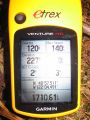
After a brief period of concern during which it was determined that Robyn had accidentally copied coordinates for the previous day's geohash, we learned we were two kilometres (not 22.3) from the geohash, and almost at the park. Unless the hill to end all hills suddenly appeared in front of us, we were going to make the four o' clock meet. And we did.
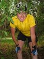
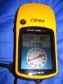
The geohash was about seven metres from the side of the road, in a patch of brush behind a row of trees. We quickly found a point where both GPS units reported the point within their circle of accuracy, did a brief GPS dance to try and centre the flickering indications for a photograph, then settled for 2m away with 3m accuracy. We chalkmarked the nearest point on the road, waited until just after four p.m. and then decided we were the only geohashers to attend this meetup, and set off to claim a campsite within a kilometre, in order to fulfil the requirements of the Camping geohash achievement.
At this point Robyn confided to Rhonda that the border crossing official had asked her a question that struck fear into her heart. It was, with relation to camping in Silver Lake Park, "Are you going to ride all the way up there tonight?" When Robyn answered in the affirmative and assured him that it was only another 30 km (and this was about one-thirty p.m.), he said darkly, "Oh you've ridden that way before have you?" Robyn said "no" very quietly, and did not ask further questions, not wanting to know just how bad the road could be that 30 km would be a startling distance to cover in twice the time it took us to go 45 km on Orcas Island.
Setting up camp

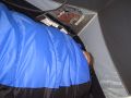
We couldn't camp right at the site, because aside from the inconvenience of tree stumps and brambles, it wasn't part of the park. We rode back up the road and entered the park, looking for the tent camping area. Our task was made more difficult by going in the wrong direction on an unsigned one-way road, but we were pretty sure we could safely pass a Winnebago coming the other way, so we kept going. Loop three, the tenting area, was almost deserted, so we were able to choose the nearest tent site to the geohash. That was a good thing, because the campsites were a few hundred metres from the edge of the park, putting our tent 937 m from the geohash, just within the one kilometre qualifying distance. We, and surely other geohashers too, will try again for a more perfectly situated campsite.
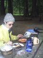
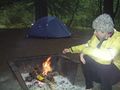
Ours was very fine, however, and by five p.m. we had the tent set up and water boiling for the first course of dinner: soup. While we were eating the soup course, we made rice, in order to prepare the second course: smoked salmon sushi. The third course was a selection of nuts. We then lit a campfire and proceeded to the dessert course, half a bag of toasted marshmallows, each. Girls have to get their daily minimum requirement of sugar and gelatin. I think there were three left after we had each eaten our fill, including one each in our after-dinner hot chocolate. We were planning on playing 1000 Blank White Cards (that's why T-Rex has his pencil ready in the pictures) but it was dark and we were tired, so we just did the dishes and went to bed. They day had included 96.66 km of riding over 5h 11 minutes for Robyn and about half that for Rhonda.
Sleep and breakfast

It started raining just before we went to bed and rained all night, but the tent stayed dry. We tried to take some inside the tent view pictures of the raindrops on the outside, but although we could see the raindrops ourselves, the tent seems to be as impermeable to camera vision as it is to raindrops, and the pictures are nothing more than dull closeups of the inside of the tent. We considered playing 1000 Blank White Cards instead of leaving the warm dry tent, but biology placed certain demands on us, and once we had gotten up to take care of those, we figured we might as well continue with the morning.
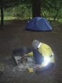
The first priority was to light the stove, which had unfortunately got rainwater in it overnight, despite the tarpaulin. Lighting it the normal way didn't work. Lighting after overpumping it didn't work. Lighting it after burning a couple of drops of naptha directly on the burner didn't work. Nor did lighting it after adding more fuel and lighting it after turning it upside-down and shaking it to get water out. What finally did the trick was pouring an alarming amount of naptha in the burner, setting the entire thing on fire, waiting for the water to evaporate from whatever internals it had got into, waiting some more for the fire to almost die out, and then turning on the gas. We don't recommend this technique for general use, and we're pretty sure the manufacturer didn't either, but it was nice to have hot food.
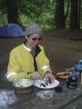
Breakfast was lemon-ginger tea, scrambled eggs with oregano (and slightly too much salt, sorry), and bananas. We considered adding Quaker Oats to the menu, but we had had enough. After a walking tour of the campground, we packed everything up and continued the adventure.
On to the next geohash
The adventure continues with 2009-05-03 48 -122.
Photos
Right at the geohash
Obligatory proof
Sushi creation
Sushi cutting
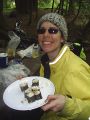
Sushi presentation
Robyn starting the campfire
Roasting marshmallows
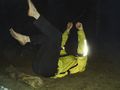
She's just resting!
Rhonda demonstrates proper resting technique
Still there the next morning


