2009-05-09 50 -119
| Sat 9 May 2009 in 50,-119: 50.6692014, -119.0335969 geohashing.info google osm bing/os kml crox |
Adventures on and off a logging road.
Contents
Location
Up a hill, near a switchback on a forest service road near Mara Lake.
Participants
Planning
This geohash was situated on the side of a hill near the unincorporated area of Mara. Juventas and Rhonda looked at backroads maps and determined that the Hunter-Blurton Forest Service Road would take us almost all the way to the geohash. That would give us a short scramble to the geohash itself and plenty of time to drive back down and go on to the next graticule. We would leave Robyn's car in Mara and travel all together in Juventas' car.
So the plan was: drive to Mara, find road, park Robyn's car, drive almost to geohash, walk 50 metres through bush, tag geohash, reverse.
Expedition
We packed up and left the campground where we'd stayed after the previous night's geohash and drove in convoy to Mara. It was just over 50 km, and in the same valley, so nothing compared to the previous day's travel, and we soon passed Grindrod, the last place before Mara, and started looking.
Searching for the right logging road
Just inside Mara, Juventas pulled off the highway into a road signed as Zettergreen. He explained that he wasn't certain where the access point was, but it should be close around here, and as a Forest Service Road we knew it should not be gated or otherwise inaccessible. We expected it to be in pretty good repair as well. Robyn could most likely park at the side by the beginning of the road. Rhonda figured out that the access was between the two places that "Riverside Road" met the highway, and that we'd already passed one, so if we saw Riverside Road again, we'd gone too far. We pulled back onto the highway and watched carefully for something that could have been the beginning of an FSR. We saw Riverside Road again.
We turned the convoy around and headed back the other way, driving really slowly with four way flashers on, determined not to miss this hidden access road. There were little roads into the trees and grand entrances to ranches, but they all had house numbers or "Private Road" signs on them. After passing Zettergreen Road we reached an access road that on the way up we had seen only as a private drive, but from this direction could be seen to fork right after leaving the highway. This must be our road. It was immediately steep and narrow, and not suitable for Robyn to drive or park on, so we all returned to the Mara gas station we had passed (what, two or three times now?) to park Robyn's car and transfer gear.
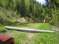
The entire party, Rhonda and Juventas in the front, Robyn and T-Rex in the back, headed back to the access road, off the highway, up the steep gravel road, and then stopped. Someone had placed a length of culvert pipe right across the road. That's another way of saying "Private Property - No Trespassing." It was still the wrong road.

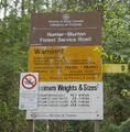
We went back to Zettergreen Road to investigate if there might be FSR access through there somehow. The pulloff signed as Zettergreen went in two possible directions. One was very clearly a private road, and one looked like a private road leading to a house, but wasn't actually signed as such so we drove along it, passed the house and found a real road. In fact, after a few corners, we found the Hunter-Blurton FSR. Victory!
The problem with the Forest Service Roads isn't that they aren't well posted and maintained, it's that the Crown Lands (i.e. land attributed to the Queen/government, hence public land) are also crisscrossed with roads leading to private homes on the edge of Crown Land, roads to cattle grazing areas, logging roads, skidder tracks, places where someone turned off the road to go off-roading, and things that look like roads, right down to deer trails, which don't look like roads at all, just very narrow trails with lots of poop pellets on them. An FSR has a sign at the beginning, and may have a sign indicating which road is which if it crosses another FSR, but other kinds of road crossing an FSR are not signed. So it's easy to follow the road marked by the sign, but later not be on that road, even though you didn't knowingly turn off it.
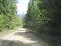
We started up the Hunter-Blurton road, choosing the most FSR-like road at each junction. We were pretty sure of our choices, as the others seemed to go to private homes. It was a good surface, but still bumpy, and as it climbed a steep hill there were lots of switchbacks. Robyn held on tightly to T-Rex, so he would not be frightened. The switchbacks, and Robyn, calmed down after a while and Robyn started calling out GPS distances. We drew within 1.77 km of the geohash, but then started pulling away again. By the time we were 2.5 km from the geohash, this was determined to be the wrong road. We turned around and went back to the point of closest approach. The bush was pretty thick, and 1.77 km is an appallingly long stupidity distance, especially as we had two creeks to cross, so we continued back to a likely turnoff. At first it appeared to be going to a house under construction, or some kind of gravel-crushing operation, but we wound around past those things and discovered another road. We went up. It was in good enough shape that we could believe it was an FSR, but then it got worse and at a fork Juventas declared that it was no longer suitable to continue. We were, at this point, about 1.4 kilometres from the geohash, so we decided to leave the car and continue walking up the road, marking its location with the GPS and chocking the tires against the steep hill with pieces of a fallen tree that we found nearby.
Hiking up
The road was very enjoyable for walking. It had strawberry plants growing in it (no strawberries this early in the year). There were a few trees fallen across it that we had to climb over or duck under, but nothing strenuous. Every time we worried about it going away from the geohash it would turn back closer. Dirt roads through the forest need a lot of maintenance, and if the map, or the data the map was made from, is a little bit out of date, the road becomes impassable to cars. It wouldn't take too long to be difficult to hike, too, but for now it was fine.
The road turned and went along beside a gully, which was good because we'd crossed one creek already, so this must be the second creek, indicating we were on course. It turned away from the gully so we presumed we would cross that stream later, and then we came out at a rather unexpected site: an open meadow. It had lush grass, a few fences, but no buildings or other indications of farming anywhere. A wide trail or road could clearly be seen leaving it on the other side. This being Crown Land, there were no private property signs. The fence was there to keep animals in, not to keep us out, and there were no animals in the field. We crossed the fence and walked across the field. The other fences had open gates or no gates at all.
On the other side of the field the road leading out looked almost like a driveway, but it didn't go anywhere, just stopped against the hill, after crossing a stream. We crossed the stream and started up the bank on the other side, leaving the road with a stupidity distance of 1.2 km.
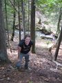
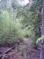
Straight up that bank wasn't bad. The trees were well spaced and the footing was stable, with some interesting rocks and logs to stand on. We emerged at a road, but decided that it didn't go the right way, so continued into the bush. The next area we walked through had some fairly mature trees. As the trees get older they block off the light to the ground below so that they have almost no ground-level branches and very little grows under the trees. We then came across a more recently planted cutblock, with young trees and the ground still open to sunlight so lots of other underbrush as well. It wouldn't have been as easy walking, so we dodged right and went around the new growth.
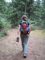
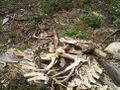
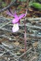
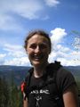
The whole area is divided into cutblocks, with various sections growing, being harvested, or awaiting replanting at any time. From the air you see it as a patchwork of various shades of green and brown, with the green being the most recently replanted and the brown the most recently harvested. We circled around the mature trees and then came out in a big open recently harvested area. It was a steep upslope (are all geohashes uphill?) with stumps and debris on it, but also a lot of plants taking advantage of the open area. Lots of thorns and spiky things, a few flowers, including some rare ones, lots of deer droppings, and even the remains of an entire deer. It was slow going, and halfway up it the geohash was still 400 metres away. That put it past the edge of the cutblock and into the standing trees visible at the top. We tried to stop to rest, but whenever we stopped moving the mosquitoes found us, so we just kept going. We all found separate tracks across that clearing, having different personal priorities for footing, directness and things to photograph, and then we entered the forest on the other side. It had some very steep parts, but the geohash was now only 200 metres away and Robyn pulled her usual trick of being unable to contain her enthusiasm and racing ahead. She climbed up the steepest part and found herself on a very fine road, 99 metres from the geohash. "Double digits!" The road curved around the hill where the geohash was, but didn't switch back towards it, so the direct route remained in effect for the last 100 metres. Robyn sat down on a stump at the geohash, where she could see a better route up, and described it to the others.
Success!
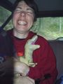
Everyone made it to the geohash and we celebrated with marshmallows and bananas. The vegetation that covered the area was too sharp and prickly for Twister and we hadn't brought (and didn't remember exactly) the rules to 1000 Blank White Cards. Juventas lay on the ground. Rhonda took a turn sitting on the stump. Robyn opened a bag of marshmallows that it had become evident we weren't going to have opportunity to toast. An extremely large bumblebee came to try to share the marshmallows, but didn't understand how marshmallows worked, so really didn't do as well as T-Rex in the marshmallow consumption department and settled for licking sugar residue off Rhonda's water bottle lid. After the usual round of photography and showing Juventas that we really could eat a whole bag of marshmallows at one sitting, we started down.
Walking down
After walking the hundred metres back to the road from the scrubby hill, we followed that excellent road. It was probably the road we had seen in the satellite photo, and the road we should have taken in the first place. We certainly didn't want to go back the way we had come. Little purple butterflies followed us down the road as we zigzagged through a couple of switchbacks. This wasn't any of the roads that we had crossed on the way up, as it followed a route to the south east of our original track.
We reached a widening in the road where there was a large earth mover, but the keys weren't in the ignition, so we didn't try driving it. It was one kilometre to the car and when we looked out over the edge in the direction of the car waypoint, we could see a field that was clearly the field we had crossed earlier. Juventas was in favour of heading over the edge and through about 400 metres of bush to the field, but Rhonda was in favour of staying on the road. Robyn preferred the road to the bushes too, at this point, so we continued on the road.
After the road had continued straight for some time and Robyn confirmed that we were now 1.4 km from the geohash, we had another conversation about the wisdom of taking this road. Rhonda still thought that it was the road we should have been on in the first place. We decided that we would continue on it for fifteen more minutes, and that if after that time it did not show definite signs of being a road that would either hook up with where we had been, or return to the highway, as opposed to a road that went for thirty kilometres through the woods to more cutblocks, then we would turn around and bushwhack.
We crossed a stream and a couple of cattleguards and then the road started curving back towards the original road that we had rejected as too far from the geohash. Our route met the original GPS trackline at exactly fifteen minutes after our agreement. Another U-Turn would not be required. We walked the rest of the way back down the road, giving Robyn a chance to see the parts she had missed due to being in the back seat (with her eyes closed, and screaming). As we walked back through the area that sort of looked like a home under construction and a rock crushing operation, an owner came out to ask us what we were doing. It turned out that it was a private home under construction and a rock crushing operation. We told her our story of trying to find the forest road and apologized for being on their property, assuring her that we wouldn't have come this way had there been a "private road" sign. She said that they didn't really want to put something like that up, and they were mainly worried about the snowmobilers in the winter who park their trucks everywhere and block the road. Her husband came up with Olivia, the fourteen-month old member of the family. She was far less impressed by T-Rex than most children, and mother explained that it was mainly plants that held her interest. They had no problem letting us go back through to retrieve our car.
We did so, and waved at the house as we drove back down to retrieve Robyn's car.
Parting
We had had hopes of going on to the next hash point, but Juventas said that while it was accessible, it was unsuitable for camping, so we thanked each other for a fine two days of adventure and parted ways. Juventas went home and Robyn and Rhonda went to Salmon Arm and visited Robyn's mother, eventually staying overnight and helping her learn to use her new digital camera. Hmmm. maybe she can learn to geohash.
After breakfast the next day Robyn and Rhonda headed to yet another hash point.
GPS Tracklog
Zoom in on the end of the trip, in the hills, and switch over to satellite view. You probably aren't interested in the part on the highway. When you look at the tracklog note that the trees grow and are harvested all the time, so the bare parts on Google Maps were actually young trees for us and some of the treed parts were new clearings.
Things to look at:
- the multiple overlaid tracks of the cars going back and forth on the highway trying to find the access road.
- the route where we went along the correct road and did a U-turn, only to meet up with that road again on the way down
- a phantom loop just past the geohash location that makes it look like I turned on the GPS partway down, then went up the hill and down again. I didn't. The track is recording the low precision of the position when I turned on the GPS back on as we started down the hill.
Photos
We tried some wrong roads
Then found the right road
It was nice and wide
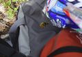
We stopped on a narrower road
Which Robyn didn't like much
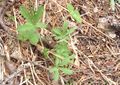
We saw interesting plants
An unexpected meadow
Across a stream and up a bank
Along another road
avoiding Google maps' friendly bright green
and avoiding the fate of this deer
Spotting rare purple flowers
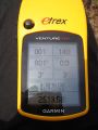
At the coordinates
At the top of the hill
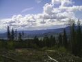
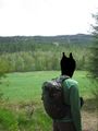
View from the top
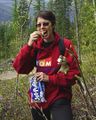
Snack time
A visitor
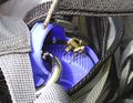
Same visitor
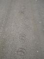
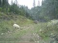
A bear took this road too.


