2009-06-30 49 9
| Tue 30 Jun 2009 in Würzburg: 49.7209504, 9.8501645 geohashing.info google osm bing/os kml crox |
Location
Today's location is in the forest near Kleinrinderfeld-Limbachshof, not far from the 2008-12-08 hashpoint.
Country: Germany; state: Bayern (Bavaria, EU:DE:BY); administrative region: Unterfranken; district: Würzburg rural district
Weather (16:00): sunny, 26°C between the trees
Expedition
Danatar
I wanted to go together with srs0 and thepiguy, but because of time constaints I had to set out suddenly at 3 pm or stay at home.
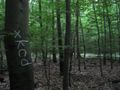
I used the route through the Steinbachtal like on 2009-01-29, then turned right and cycled through Kist to Limbachshof. I left my bike on the track near the hashpoint and vanished between the trees. For most of the last metres I could follow something that might have been a deer trail, fighting off insects all the way. When I had gone as far as the satellite picture indicated, I declared a more or less random tree to be the hashpoint and chalked it with the well-known four-letter-word four letters. Then I went back the same way as before.
Total distance by bike: 16 + 14.5 = 30.5 km; 360 m uphill. I'm not sure if the return distance is correct, because google shows one kilometer more on the route I took and on the there trip I only made a 200m detour, but that's what the odometer says.
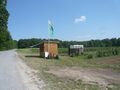
Pick-your-own-strawberries near the hashpoint

Coordinates reached


Srs0
Srs0 had every intention of going, but didn't end up making it. He would have set out with Danatar, but the next bus was an hour later, so he'd be too late to meet him. Then, he planned to go with thepiguy, but when he checked the bus schedules he found that it was early enough to get a bus to the geohash, but too late to get a bus back. As such, he sat at home instead. Too bad, maybe next time.
thepiguy
thepiguy set out later in the day after work. He discovered Danatar's markings within 18m of where he found the coordinates to be. Amazing!
thepiguy discovers a strange marking on the path.
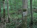
And another. What could it mean?
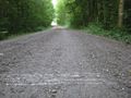
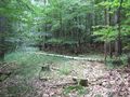
100m through the forest and I think I'm there...
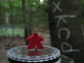
Murray agrees.
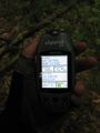
Out comes the GPS. Less than 20m from the tree!
Quite nice actually.

Two kinds of fuzzy!


